- Tequesta
-
This article is about the Native American tribe. For other uses, see Tequesta (disambiguation).
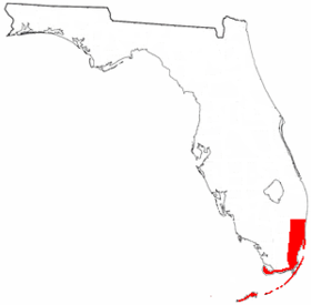 Approximate territory of the Tequesta in the 16th century
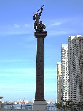 Bronze statue of a Tequesta warrior and his family on the Brickell Avenue Bridge
The Tequesta (also Tekesta, Tegesta, Chequesta, Vizcaynos) Native American tribe, at the time of first European contact, occupied an area along the southeastern Atlantic coast of Florida. They had infrequent contact with Europeans and had largely disappeared by the middle of the 18th century.
Contents
Location and extent
The Tequesta tribe lived on Biscayne Bay [1] in what are now Miami-Dade County and at least the southern half of Broward County. Their territory may have also included the northern half of Broward County. They also occupied the Florida Keys at times, and may have had a village on Cape Sable, at the southern end of the Florida peninsula, in the 16th Century. The central town (also called Tequesta) was probably at the mouth of the Miami River. A village had been at that site at least since 1200. The tribal chief was also called Tequesta. The Tequestas arrived in the Biscayne Bay area before the beginning of the Current Era. The Tequestas placed their towns and camps at the mouths of rivers and streams, on inlets from the Atlantic Ocean to inland waters, and on barrier islands and keys.[2] The Tequestas were more or less dominated by the more numerous Calusa of the southwest coast of Florida. The Tequestas were closely allied to their immediate neighbors to the north, the Jaega.[3] Estimates of the number of Tequestas at the time of initial European contact range from 800 to 10,000, while estimates of the number of Calusas on the southwest coast of Florida range from 2,000 to 20,000. Occupation of the Florida Keys may have swung back and forth between the two tribes. Although there is a Spanish record of a Tequesta village on Cape Sable, Calusa artifacts outnumber Tequesta artifacts by four to one at archaeological sites there.
On a map the Dutch cartographer Hessel Gerritsz published in 1630 in Joannes de Laet's History of the New World, the Florida peninsula is labeled "Tegesta" after the tribe.[4] A map from the 18th century labeled the area around Biscayne Bay "Tekesta".[5] A 1794 map[6] by cartographer Bernard Romans labeled this area "Tegesta".
Origins and language
The archaeological record of the Glades culture, which included the area occupied by the Tequestas, indicates a continuous development of an indigenous ceramics tradition from about 700 BCE until after European contact.[7] The Tequesta language may have been closely related to the language of the Calusas of the southwest Florida coast and the Mayaimis who lived around Lake Okeechobee in the middle of the lower Florida peninsula. There are only ten words from the languages of those tribes for which meanings were recorded.[8] The Tequesta were once thought to be related to the Taino, the Arawakan people of the Antilles, but most anthropologists now doubt this, based on archaeological information and the length of their establishment in Florida. Carl O. Sauer called the Florida Straits "one of the most strongly marked cultural boundaries in the New World", noting that the Straits were also a boundary between agricultural systems, with Florida Indians growing seed crops that originated in Mexico, while the Lucayans of the Bahamas grew root crops that originated in South America.[9]
Diet
The Tequestas did practice any form of agriculture. They fished, hunted, and gathered the fruit and roots of local plants. Most of their food came from the sea. Hernando de Escalante Fontaneda, who lived among the tribes of southern Florida for seventeen years in the 16th Century, described their "common" diet as "fish, turtle and snails, and tunny and whale..."; the "sea-wolf" (Caribbean monk seal) was reserved for the upper classes. According to Fontaneda, a lesser part of the diet consisted of trunkfish and lobster. The "fish" caught included manatees, sharks, sailfish, porpoises, stingrays, and small fish. Despite their local abundance, clams, oysters and conchs were only a minor part of the Tequesta diet (their shells are much less common at Tequesta archeological sites than they are at Calusa or Jaega sites). Venison also
popular; deer bones are frequently found in archeological sites, as are terrapin shells and bones. Sea turtles and their eggs were consumed during the turtles' nesting season.[8]
The Tequesta gathered many plant foods, including saw palmetto (Serenoa repens) berries, cocoplums (Chrysobalanus icaco), sea grapes (Coccoloba uvifera), prickly pear fruits (Opuntia spp.), gopher apples (Licania micbauxii), pigeon plums (Cocoloba diversifolia), palm nuts, false mastic (Mastichodedron) seeds, cabbage palm (Sabal palmetto) and hog plum (Ximenia americana). The roots of certain plants, such as Smilax spp. and coontie (Zamia integrifolia), were edible when ground into flour, processed to remove toxins (in the case of coontie), and made into a type of unleavened bread. (Archaeologists have commented, however, on the lack of evidence for coontie use in excavated sites.) Briton Hammond, the sole survivor of an English sloop that was attacked by Tequestas after grounding off Key Biscayne in 1748, reported that the Tequestas fed him boil'd corn.[10]
The Tequestas changed their habitation during the year. In particular, most of the inhabitants of the main village relocated to barrier islands or to the Florida Keys during the worst of the mosquito season, which lasted about three months. While the resources of the Biscayne Bay area and the Florida Keys allowed for a somewhat settled non-agricultural existence, they were not as rich as those of the southwest Florida coast, home of the more numerous Calusa.[11]
Housing, clothing and tools
Briton Hammond reported that the Tequesta lived in hutts. No other description is not available of Tequesta housing. Other tribes in southern Florida lived in houses with wooden posts, raised floors, and roofs thatched with palmetto leaves, something like the chickees of the Seminoles. These houses may have had temporary walls of plaited palmetto-leaf mats to break the wind or block the sun.
Clothing was minimal. The men wore a sort of loincloth made from deer hide, while the women wore skirts of Spanish moss or plant fibers hanging from a belt.
The Tequesta had ocean-going canoes [that were carved with shark teeth], nets, spears, atlatls, bows and arrows (although they may have acquired those after European contact) and utilitarian pottery with little or no decoration.
Customs
By one account, when the Tequestas buried their chiefs, they buried the small bones with the body, and put the large bones in a box for the village people to adore and hold as their gods. Another account says that the Tequestas stripped the flesh from the bones, burning the flesh, and then distributed the cleaned bones to the dead chief's relatives, with the larger bones going to the closest relations.
The Tequesta men consumed cassina, the black drink, in ceremonies similar to those common throughout the southeastern United States.
The Spanish missionaries also reported that the Tequesta worshipped a stuffed deer as the representative of the sun, and as late as 1743 worshipped a picture of a badly deformed barracuda crossed by a harpoon, and surrounded by small tongue-like figures painted on a small board. There was also a god of the graveyard, a bird's head carved in pine. The painted board and bird's head were stored in a temple in the cemetery, along with carved masks used in festivals. By this time the tribe's shaman was calling himself a bishop.
The Tequestas may have practiced human sacrifice. While enroute from Havana to Biscayne Bay in 1743, Spanish missionaries heard that the Indians of the Keys (including, apparently, the Tequestas) had gone to Santaluz (the village of Santa Lucea was at the St. Lucie Inlet) for a celebration of a recent peace treaty, and that the chief of Santaluz was going to sacrifice a young girl as part of the celebration. The missionaries sent a message to the chief begging him not to sacrifice the girl, and the chief relented.
Miami Circle
The Miami Circle [12] is located on the site of a known Tequesta village south of the mouth of the Miami River (probably the town of Tequesta). It consists of 24 large holes or basins, and many smaller holes, which have been cut into bedrock. Together these holes form a circle approximately 38 feet in diameter. Other arrangements of holes are apparent as well. The Circle was discovered during an archeological survey of a site being cleared for construction of a high-rise building. Charcoal samples collected in the circle have been radiocarbon-dated to approximately 1,900 years ago.
Post-European-contact History
In 1513 Juan Ponce de Leon stopped at a bay on the Florida coast that he called Chequesta, which apparently was what is now called Biscayne Bay. In 1565 one of the ships in Pedro Menéndez de Avilés' fleet took refuge from a storm in Biscayne Bay. The main Tequesta village was located there, and Menéndez was well received by the Tequestas. The Jesuits with him took the Tequesta chief's nephew with them back to Havana, Cuba, to be educated, while the chief's brother went to Spain with Menéndez, where he converted to Christianity. In March of 1567, Menéndez returned to the Tequesta[1] and established a mission within a stockade, situated near the south bank of the Miami River below the native village. Menendez left a contingent of thirty soldiers and the Jesuit brother Francisco Villareal to convert the Tequestas to Christianity. Villareal had learned something of the Tequesta language from the chief's nephew in Havana. He felt he had been winning converts until the soldiers executed an uncle of the chief. Brother Francisco was forced to abandon the mission for a while, but when the chief's brother returned from Spain, Brother Francisco was able to return. However, the mission was abandoned shortly thereafter, in 1570.
Starting in 1704, it was the policy of the Spanish government to resettle Florida Indians in Cuba so that they could be indoctrinated into the Catholic faith. The first group of Indians, including the cacique of Cayo de Guesos (Key West), arrived in Cuba in 1704, and most, if not all of them, soon died. In 1710, 280 Florida Indians were taken to Cuba, where almost 200 soon died. The survivors were returned to the Keys in 1716 or 1718. In 1732 some Indians fled from the Keys to Cuba.
In early 1743 the Governor of Cuba received a petition from three Calusa chiefs who were visiting in Havana. The petition, which was written in good Spanish and showed a good understanding of how the government and church bureaucracies worked, asked that missionaries be sent to the Cayos (Florida Keys) to provide religious instruction. The Governor and his advisors finally decided it would be cheaper to send missionaries to the Keys rather than bringing the Indians to Cuba, and that keeping the Indians in the Keys would mean they would be available to help shipwrecked Spanish sailors and keep the English out of the area.
The governor sent two Jesuit missionaries from Havana, Fathers Mónaco and Alaña, with an escort of soldiers. On reaching Biscayne Bay, they established a chapel and fort at the mouth of a river feeding into Biscayne Bay that they called the Rio Ratones. This may have been the Little River, in the northern part of Biscayne Bay, or the Miami River.
The Spanish missionaries were not well received. The Keys Indians, as the Spanish called them, denied that they had requested missionaries. They did permit a mission to be established because the Spanish had brought gifts for them, but the cacique denied that the King of Spain had dominion over his land, and insisted on tribute for allowing the Spanish to build a church or bring in settlers. The Indians demanded food, rum and clothing, but refused to work for the Spanish. Father Morano reported attacks on the mission by bands of Uchizas (the Creeks who later became known as Seminoles).
Fathers Mónaco and Alaña developed a plan to have a stockade manned by twenty-five soldiers, and to bring in Spanish settlers to grow food for the soldiers and the Indians. They felt that the new settlement would soon supplant the need for St. Augustine. Father Alaña returned to Havana,leaving twelve soldiers and a corporal to protect Father Mónaco.
The governor in Havana was not pleased. He ordered that Father Mónaco and the soldiers be withdrawn, and the stockade burned to deny it to the Uchizas. He also forwarded the missionaries' plan to Spain, where the Council of the Indies decided that the proposed mission on Biscayne Bay would be costly and impractical. The second attempt to establish a mission on Biscayne Bay had lasted less than three months.
When Spain surrendered Florida to Britain in 1763, the remaining Tequestas, along with other Indians that had taken refuge in the Florida Keys, were evacuated to Cuba.[13] In the 1770s, Bernard Romans reported seeing abandoned villages in the area, but no inhabitants.
Footnotes
- ^ a b "The Caloosa Village Tequesta A Miami of the Sixteenth Century by Robert E. McNicoll", Florida International University
- ^ Hann 2003:140-1
- ^ Hann 2003:139
- ^ Ehrenberg, Ralph E. "Marvellous countries and lands" Notable Maps of Florida, 1507-1846
- ^ "Old Florida Maps", University of Miami Libraries
- ^ "Old Florida Maps", University of Miami Libraries
- ^ Florida Office of Cultural and Historical Programs. P. 89
- ^ a b Austin
- ^ Sauer, p. 51.
- ^ Austin
Hann 2003:147 - ^ Hann 2003:146
- ^ "Miami Circle", Florida Division of Historical Resources
- ^ "Native Peoples", National Park System, United States Department of the Interior
References
- State of Florida Office of Cultural and Historical Programs. "Chapter 12. South and Southeast Florida: The Everglades Region, 2500 B.P.-Contact". Historic Contexts. Version of 9-27-93. Downloaded from [1] on March 27, 2006
- Austin, Daniel W. (1997). "The Glades Indians and the Plants they Used. Ethnobotany of an Extinct Culture." The Palmetto, 17(2):7 -11.[2] - accessed December 4, 2005
- Brickell Point - Home of the Miami Circle (State of Florida site) - accessed December 4, 2005
- Bullen, Adelaide K. (1965). "Florida Indians of Past and Present". In Ruby L. Carson & Charlton Tebeau (Eds.), Florida from Indian trail to space age: a history (Vol. I, pp. 317–350). Southern Publishing Company.
- Escalente Fontaneda, Hernando de. (1944). Memoir of Do. d'Escalente Fontaneda respecting Florida. Smith, B. (Trans.); True, D. O. (Ed.). Miami: University of Miami & Historical Association of Southern Florida.
- Goddard, Ives. (2005). The indigenous languages of the Southeast. Anthropological Linguistics, 47 (1), 1-60.
- Hann, John H. (1991). Missions to the Calusa. Gainesville: University of Florida Press.
- Hann, John H. (2003). Indians of Central and South Florida: 1513-1763. University Press of Florida. ISBN 0-8130-2645-8
- Sauer, Carl Otwin. 1966. (Fourth printing, 1992.) The Early Spanish Main. The University of California Press. ISBN 0-520-01415-4
- Sturtevant, William C. (1978). "The Last of the South Florida Aborigines". In Jeral Milanich & Samuel Proctor (Eds.). Tacachale: Essays on the Indians of Florida and Southeastern Georgia during the Historic Period. Gainesville, Florida: The University Presses of Florida. ISBN 0-8130-0535-3
- Tebeau, Charlton W. (1968). Man in the Everglades (pp. 37–45). Coral Gables, Florida: University of Miami Press. Library of Congress Catalog Card Number: 68-17768
- The Tequesta of Biscayne Bay - accessed December 4, 2005
- Wenhold, Lucy L. (Ed., Trans.). (1936). A 17th century letter of Gabriel Diaz Vara Calderón, Bishop of Cuba, describing the Indians and Indian missions of Florida. Smithsonian miscellaneous collections 95 (16). Washington, D.C.: Smithsonian Institution.
Categories:- Native American tribes in Florida
- Pre-state history of Florida


Wikimedia Foundation. 2010.