- Maize, Kansas
-
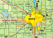
Maize, Kansas — City — Motto: "Where Community Counts" Location of Maize, Kansas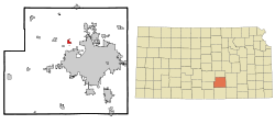 Detailed map of Maize
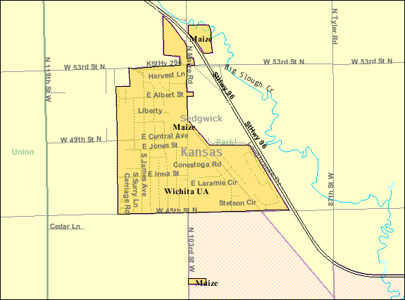
Coordinates: 37°46′45″N 97°28′2″W / 37.77917°N 97.46722°WCoordinates: 37°46′45″N 97°28′2″W / 37.77917°N 97.46722°W Country United States State Kansas County Sedgwick Founded 1886 Incorporated 1915 Government - Mayor Clair Donnelly Area - Total 0.8 sq mi (2.1 km2) - Land 0.8 sq mi (2.1 km2) - Water 0.0 sq mi (0.0 km2) Elevation 1,348 ft (411 m) Population (2010)[1] - Total 3,420 - Density 4,275/sq mi (1,650.6/km2) Time zone Central (CST) (UTC-6) - Summer (DST) CDT (UTC-5) ZIP code 67101 Area code(s) 316 FIPS code 20-44200[2] GNIS feature ID 0473821[3] Website www.CityOfMaize.org Maize is a city in Sedgwick County, Kansas, United States. It is a suburb of Wichita.[4] As of the 2010 census, the city population was 3,420.[1]
Contents
History
The Maize Town Company, led by N. F. Neiderlander, founded Maize in 1886 at the first stop outside of Wichita on the Wichita and Colorado Railway. The post office opened that same year as did the town's first church, having relocated from nearby. Maize's first school opened in 1887; its first newspaper opened in 1895. Maize State Bank, the town's first financial institution, opened in 1901, and, by 1908, a business community had emerged. In 1915, the Maize Town Company dissolved, and Maize was incorporated as a city.[5]
Several natural disasters struck Maize in the 1930s and 1940s, including the Dust Bowl in 1934-35, a plague of grasshoppers in 1936, and a flood in 1944.[5]
Maize began to grow rapidly in 1950, more than doubling in size by 1956.[5] This growth has continued, accelerating in recent years as Wichita has expanded to the northwest, and transformed Maize into a suburb.[4]
Geography
Maize is located at 37°46′45″N 97°28′2″W / 37.77917°N 97.46722°W (37.779178, -97.467267)[6] at an elevation of 1,348 feet (411 m).[3] It lies on the west side of Big Slough Creek roughly 3 miles (4.8 km) southwest of the Arkansas River in the Wellington-McPherson Lowlands region of the Great Plains. Located in south-central Kansas, Maize is on K-96 immediately northwest of Wichita.
According to the United States Census Bureau, the city has a total area of 0.8 square miles (2.1 km2), all of it land.
Demographics
Historical populations Census Pop. %± 1920 189 — 1930 229 21.2% 1940 198 −13.5% 1950 266 34.3% 1960 623 134.2% 1970 785 26.0% 1980 1,294 64.8% 1990 1,520 17.5% 2000 1,868 22.9% 2010 3,420 83.1% U.S. Decennial Census As of the census[2] of 2000, there were 1,868 people, 632 households, and 523 families residing in the city. The population density was 2,274.9 people per square mile (879.6/km²). There were 668 housing units at an average density of 813.5 per square mile (314.5/km²). The racial makeup of the city was 93.47% White, 0.96% African American, 1.23% Native American, 0.32% Asian, 0.91% from other races, and 3.10% from two or more races. Hispanic or Latino of any race were 2.62% of the population.
There were 632 households out of which 49.4% had children under the age of 18 living with them, 66.6% were married couples living together, 11.4% had a female householder with no husband present, and 17.2% were non-families. 15.7% of all households were made up of individuals and 6.0% had someone living alone who was 65 years of age or older. The average household size was 2.96 and the average family size was 3.28.
In the city the population was spread out with 34.4% under the age of 18, 8.0% from 18 to 24, 30.7% from 25 to 44, 19.9% from 45 to 64, and 7.1% who were 65 years of age or older. The median age was 30 years. For every 100 females there were 100.4 males. For every 100 females age 18 and over, there were 97.1 males.
The median income for a household in the city was $51,845, and the median income for a family was $53,365. Males had a median income of $41,653 versus $25,817 for females. The per capita income for the city was $18,803. About 1.9% of families and 3.0% of the population were below the poverty line, including 4.4% of those under age 18 and 1.4% of those age 65 or over.
Government
Maize has a mayor-council-administrator form of government. The city council consists of the mayor and five members who serve part-time. The mayor is elected to a four-year term while terms for council members are staggered such that two members are up for election every two years.[7]
Education
Primary and secondary education
Maize USD 266 operates ten schools in and around the city:[8]
- Early Childhood Center (Grades Pre-K)
- Maize Central Elementary School (K-5)
- Maize Elementary School (K-1)
- Maize South Elementary School (2-5)
- Pray-Woodman Elementary School (2-5)
- Maize Middle School (6-8)
- Maize South Middle School (6-8)
- Maize High School (9-12)
- Maize South High School (9-12)
- Complete High School Maize (9-12), alternative school
Infrastructure
 Map of Sedgwick County, Kansas showing Maize and surrounding communities
Transportation
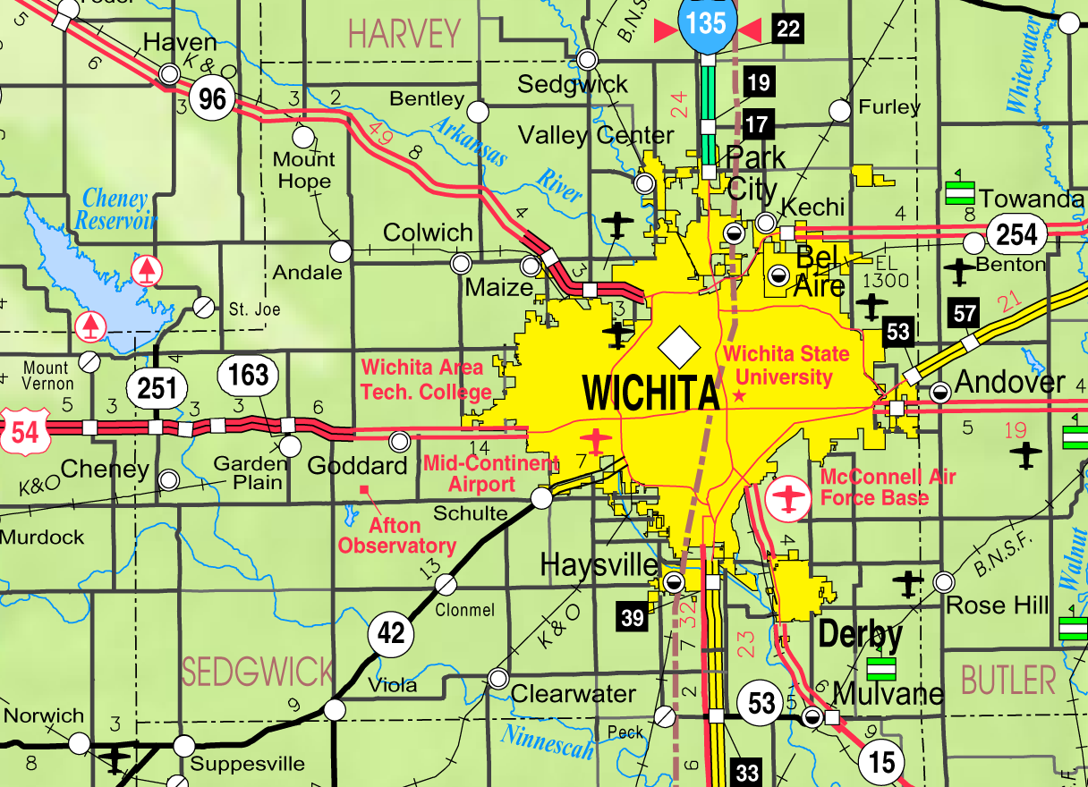
K-96 runs southeast-northwest along the northeast side of the city.
The Hutchinson line of the Kansas and Oklahoma Railroad runs southeast-northwest through Maize.
Maize Airport is a privately owned, public-use airport located two nautical miles (2.3 mi, 3.7 km) southeast of the central business district of Maize.
References
- ^ a b "2010 City Population and Housing Occupancy Status". U.S. Census Bureau. http://factfinder2.census.gov/faces/tableservices/jsf/pages/productview.xhtml?pid=DEC_10_PL_GCTPL2.ST13&prodType=table. Retrieved March 6, 2011.
- ^ a b "American FactFinder". United States Census Bureau. http://factfinder.census.gov. Retrieved 2008-01-31.
- ^ a b "US Board on Geographic Names". United States Geological Survey. 2007-10-25. http://geonames.usgs.gov. Retrieved 2008-01-31.
- ^ a b "Community". Maize Area Chamber of Commerce. 2008. http://www.maizechamber.com/community/. Retrieved 2010-08-16.
- ^ a b c "History". City of Maize. 1986. http://www.cityofmaize.org/history.php. Retrieved 2010-08-16.
- ^ "US Gazetteer files: 2010, 2000, and 1990". United States Census Bureau. 2011-02-12. http://www.census.gov/geo/www/gazetteer/gazette.html. Retrieved 2011-04-23.
- ^ "City Government". City of Maize. http://www.cityofmaize.org/govt.php. Retrieved 2010-08-17.
- ^ "Schools". Maize Unified SD 266. http://maize.usd266.com/education/components/scrapbook/default.php?sectiondetailid=2759. Retrieved 2010-08-15.
Further reading
- History of the State of Kansas; William G. Cutler; A.T. Andreas Publisher; 1883. (Online HTML eBook)
- Kansas : A Cyclopedia of State History, Embracing Events, Institutions, Industries, Counties, Cities, Towns, Prominent Persons, Etc; 3 Volumes; Frank W. Blackmar; Standard Publishing Co; 944 / 955 / 824 pages; 1912. (Volume1 - Download 54MB PDF eBook),(Volume2 - Download 53MB PDF eBook), (Volume3 - Download 33MB PDF eBook)
External links
- City
- Schools
- USD 266, local school district
- Maps
- Maize City Map, KDOT
- Sumner County Map, KDOT
Municipalities and communities of Sedgwick County, Kansas Cities Andale | Andover‡ | Bel Aire | Bentley | Cheney | Clearwater | Colwich | Derby | Eastborough | Garden Plain | Goddard | Haysville | Kechi | Maize | Mount Hope | Mulvane‡ | Park City | Sedgwick‡ | Valley Center | Viola | Wichita

CDP Unincorporated
communitiesTownships Footnotes ‡This populated place also has portions in an adjacent county or counties
Categories:- Cities in Kansas
- Populated places in Sedgwick County, Kansas
- Wichita metropolitan area


Wikimedia Foundation. 2010.