- Mulvane, Kansas
-
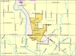
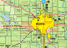
Mulvane, Kansas — City — Motto: Courtesy, Competence, Commitment Location of Mulvane, Kansas Detailed map of Mulvane, Kansas Coordinates: 37°28′47″N 97°14′32″W / 37.47972°N 97.24222°WCoordinates: 37°28′47″N 97°14′32″W / 37.47972°N 97.24222°W Country United States State Kansas Counties Sedgwick, Sumner Incorporated 1883 Government – Mayor Jim Ford Area – Total 2.3 sq mi (5.9 km2) – Land 2.3 sq mi (5.9 km2) – Water 0.0 sq mi (0.0 km2) Elevation 1,234 ft (376 m) Population (2010)[1] – Total 6,111 – Density 2,657/sq mi (1,025.9/km2) Time zone Central (CST) (UTC-6) – Summer (DST) CDT (UTC-5) ZIP code 67110 Area code(s) 316 FIPS code 20-49100[2] GNIS feature ID 0470229[3] Website www.MulvaneKansas.com Mulvane is a city in Sedgwick and Sumner counties in the U.S. state of Kansas. As of the 2010 census, the city population was 6,111.[1]
Contents
History
Mulvane was founded in August 1879 at the junction of five Santa Fe rail lines. It is named for Joab R. Mulvane. Mr. Mulvane came to Kansas in 1876.[citation needed] He resided in Topeka and in his later years spent the summer season at his island estate on Crab Lake in northern Wisconsin.[citation needed] Joab Mulvane was perhaps the most successful Kansan of his generation.[citation needed] The breadth of his interests has shaped modern Kansas and far beyond especially in shipping logistics and the strategic advantage of Kansas as a single point distribution hub for North America[4] which means his work had profound and lasting impacts. He brought many elements of the Santa Fe Railway together. He was president of at least nine railroads and he presided over the Chicago, Kansas and Western Railway Company, as its President, when it built over 900 miles of rail lines for the Santa Fe.[citation needed]. Some of his other interests included: President of: the Kansas Town Company, the Quivera Town and Land Company (which incorporated Argentine, KS in 1881),the Edison Electric Light Company of Topeka, Shawnee Fire Insurance Company, the Kansas Salt Company. He was interlocked in various other companies as vice-president or treasurer. He was a major stockholder and director of the Bank of Topeka.[5] He was married to Miss Sarah A. Ross of Ohio who hails from the famous Whitaker Steel Family. Joab Mulvane was responsible for the location of the important junction city that bears his name.[citation needed]
Mulvane's Main Street follows part of the Sedgwick and Sumner county lines, and the town center is about five miles west of the spot where Sedgwick, Sumner, Butler and Cowley counties meet.
Geography
Mulvane is located at 37°28′47″N 97°14′32″W / 37.47972°N 97.24222°W (37.479746, -97.242309)[6]. According to the United States Census Bureau, the city has a total area of 2.3 square miles (5.9 km²), all land.
Area events and attractions
- Mulvane Old Settlers Celebration is one of the longest-running community events in Kansas, having started in 1873 (three years before the town was officially incorporated).
- Mulvane is near the replica of the Golden Gate Bridge built by Larry Richardson, a retired postman, over Cowskin Creek. The bridge, a scale model 150 feet long built at a cost of $5,000 in materials, is a novelty attraction typical of midwestern towns.[7]
Demographics
Historical populations Census Pop. %± 1990 4,674 — 2000 5,155 10.3% 2010 6,111 18.5% U.S. Decennial Census As of the census[2] of 2000, there were 5,155 people, 1,896 households, and 1,444 families residing in the city. The population density was 2,261.1 people per square mile (873.0/km²). There were 1,963 housing units at an average density of 861.0 per square mile (332.4/km²). The racial makeup of the city was 96.39% White, 0.17% African American, 0.99% Native American, 0.29% Asian, 0.06% Pacific Islander, 0.60% from other races, and 1.49% from two or more races. Hispanic or Latino of any race were 2.58% of the population.
There were 1,896 households of which 41.0% had children under the age of 18 living with them, 63.0% were married couples living together, 9.3% had a female householder with no husband present, and 23.8% were non-families. 21.0% of all households were made up of individuals and 9.1% had someone living alone who was 65 years of age or older. The average household size was 2.69 and the average family size was 3.14.
In the city the population was spread out with 30.4% under the age of 18, 8.4% from 18 to 24, 28.8% from 25 to 44, 20.7% from 45 to 64, and 11.7% were 65 years of age or older. The median age was 34 years. For every 100 females there were 93.1 males. For every 100 females age 18 and over, there were 89.8 males.
The median income for a household in the city was $46,923, and the median income for a family was $56,285. Males had a median income of $39,732 versus $26,797 for females. The per capita income for the city was $19,523. About 2.1% of families and 3.4% of the population were below the poverty line, including 4.0% of those under age 18 and 1.6% of those age 65 or over.
Notable people
- Laura M. Cobb, United States Navy nurse during World War II
- Dennis Franchione, college football coach.
References
- ^ a b "2010 City Population and Housing Occupancy Status". U.S. Census Bureau. http://factfinder2.census.gov/faces/tableservices/jsf/pages/productview.xhtml?pid=DEC_10_PL_GCTPL2.ST13&prodType=table. Retrieved March 6, 2011.
- ^ a b "American FactFinder". United States Census Bureau. http://factfinder.census.gov. Retrieved 2008-01-31.
- ^ "US Board on Geographic Names". United States Geological Survey. 2007-10-25. http://geonames.usgs.gov. Retrieved 2008-01-31.
- ^ "Mulvane's Early Years: 1876-1918". Swope Design. http://www.mulvane.net/index.php?option=com_content&task=view&id=14&Itemid=57. Retrieved 5 January 2009.
- ^ William E. Connelley. "Joab Mulvane". A Standard History of Kansas and Kansans. Kansas State Historical Society, Topeka. http://skyways.lib.ks.us/genweb/archives/1918ks/biom/mulvanj.html. Retrieved 5 January 2009.
- ^ "US Gazetteer files: 2010, 2000, and 1990". United States Census Bureau. 2011-02-12. http://www.census.gov/geo/www/gazetteer/gazette.html. Retrieved 2011-04-23.
- ^ "A Golden Gate Fantasy on the Kansas Prairie" article by A.G. Suleberger in The New York Times September 15, 2010, accessed September 16, 2010
Further reading
- History of the State of Kansas; William G. Cutler; A.T. Andreas Publisher; 1883. (Online HTML eBook)
- Kansas : A Cyclopedia of State History, Embracing Events, Institutions, Industries, Counties, Cities, Towns, Prominent Persons, Etc; 3 Volumes; Frank W. Blackmar; Standard Publishing Co; 944 / 955 / 824 pages; 1912. (Volume1 - Download 54MB PDF eBook),(Volume2 - Download 53MB PDF eBook), (Volume3 - Download 33MB PDF eBook)
External links
- City
- Schools
- USD 263, local school district
- Maps
- Mulvane City Map, KDOT
- Sedgwick County Map, KDOT
- Sumner County Map, KDOT
Municipalities and communities of Sedgwick County, Kansas Cities Andale | Andover‡ | Bel Aire | Bentley | Cheney | Clearwater | Colwich | Derby | Eastborough | Garden Plain | Goddard | Haysville | Kechi | Maize | Mount Hope | Mulvane‡ | Park City | Sedgwick‡ | Valley Center | Viola | Wichita
CDP Unincorporated
communitiesTownships Footnotes ‡This populated place also has portions in an adjacent county or counties
Municipalities and communities of Sumner County, Kansas Cities Argonia | Belle Plaine | Caldwell | Conway Springs | Geuda Springs‡ | Hunnewell | Mayfield | Milan | Mulvane‡ | Oxford | South Haven | Wellington
Unincorporated
communitiesFootnotes ‡This populated place also has portions in an adjacent county or counties
Categories:- Cities in Kansas
- Populated places in Sedgwick County, Kansas
- Populated places in Sumner County, Kansas
- Wichita metropolitan area
Wikimedia Foundation. 2010.


