- Wichita metropolitan area
-
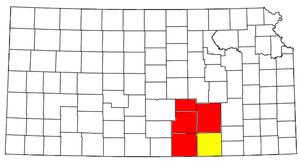 Location of the Wichita-Winfield CSA and its components:
 Wichita Metropolitan Statistical AreaWinfield Micropolitan Statistical Area
The Wichita Metropolitan Statistical Area, as defined by the United States Census Bureau, is an area consisting of four counties in south central Kansas, anchored by the city of Wichita. As of the 2010 census, the MSA had a population of 659,372. With the addition of the population of the directly adjacent Hutchinson Micropolitan Statistical Area the 2010 population of the greater Wichita area would be 723,883. It is the largest metropolitan area anchored in the state of Kansas.
Contents
Counties
Communities
Places with more than 300,000 inhabitants
- Wichita (Principal city)
Places with 10,000 to 25,000 inhabitants
Places with 5,000 to 10,000 inhabitants
Places with 1,000 to 5,000 inhabitants
- Belle Plaine
- Caldwell
- Cheney
- Clearwater
- Colwich
- Conway Springs
- Douglass
- Goddard
- Halstead
- Hesston
- Kechi
- Maize
- North Newton
- Oaklawn-Sunview (census-designated place)
- Oxford
- Rose Hill
- Sedgwick
- Towanda
Places with fewer than 1,000 inhabitants
- Andale
- Argonia
- Bentley
- Benton
- Burrton
- Cassoday
- Eastborough
- Elbing
- Garden Plain
- Geuda Springs (partial)
- Hunnewell
- Latham
- Leon
- Mayfield
- Milan
- Mount Hope
- Potwin
- South Haven
- Viola
- Walton
- Whitewater
Unincorporated places
Demographics
As of the census[1] of 2000, there were 571,166 people, 220,440 households, and 149,768families residing within the MSA. The racial makeup of the MSA was 82.36% White, 7.51% African American, 1.06% Native American, 2.73% Asian, 0.05% Pacific Islander, 3.67% from other races, and 2.62% from two or more races. Hispanic or Latino of any race were 7.23% of the population.
The median income for a household in the MSA was $42,070, and the median income for a family was $50,202. Males had a median income of $37,025 versus $24,444 for females. The per capita income for the MSA was $19,519.
Combined Statistical Area
The Wichita–Winfield Combined Statistical Area is made up of five counties in south central Kansas. The statistical area includes one metropolitan area and one micropolitan area. As of the 2000 Census, the CSA had a population of 607,457 (though a July 1, 2009 estimate placed the population at 646,317).[2]
- Metropolitan Statistical Areas (MSAs)
- Wichita (Butler, Harvey, Sedgwick, and Sumner counties)
- Micropolitan Statistical Areas (μSAs)
- Winfield (Cowley County)
See also
References
- ^ "American FactFinder". United States Census Bureau. http://factfinder.census.gov. Retrieved 2008-01-31.
- ^ "Table 2. Annual Estimates of the Population of Combined Statistical Areas: April 1, 2000 to July 1, 2009 (CBSA-EST2009-02)" (CSV). 2009 Population Estimates. United States Census Bureau, Population Division. 2010-03-23. http://www.census.gov/popest/metro/tables/2009/CBSA-EST2009-02.csv. Retrieved 2010-03-27.

Wikimedia Foundation. 2010.