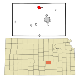
- Hesston, Kansas
Infobox Settlement
official_name = Hesston, Kansas
settlement_type =City
nickname =
motto =
imagesize =
image_caption =
image_
imagesize =
image_caption =
image_
mapsize = 250px
map_caption = Location of Hesston, Kansas
mapsize1 =
map_caption1 =subdivision_type = Country
subdivision_name =United States
subdivision_type1 = State
subdivision_name1 =Kansas
subdivision_type2 = County
subdivision_name2 = Harvey
government_footnotes =
government_type =
leader_title =
leader_name =
leader_title1 =
leader_name1 =
established_title =
established_date =unit_pref = Imperial
area_footnotes =
area_magnitude =
area_total_km2 = 6.7
area_land_km2 = 6.7
area_water_km2 = 0.0
area_total_sq_mi = 2.6
area_land_sq_mi = 2.6
area_water_sq_mi = 0.0population_as_of = 2000
population_footnotes =
population_total = 3509
population_density_km2 = 522.5
population_density_sq_mi = 1353.2timezone = Central (CST)
utc_offset = -6
timezone_DST = CDT
utc_offset_DST = -5
elevation_footnotes =
elevation_m = 451
elevation_ft = 1480
latd = 38 |latm = 8 |lats = 21 |latNS = N
longd = 97 |longm = 25 |longs = 46 |longEW = Wpostal_code_type =
ZIP code
postal_code = 67062
area_code = 620
blank_name = FIPS code
blank_info = 20-31600GR|2
blank1_name = GNIS feature ID
blank1_info = 0477759GR|3
website =
footnotes =Hesston is a city in Harvey County,
Kansas ,United States . The population was 3,509 at the 2000 census.History
Established in 1886 as a village in Emma Township, Hesston began to grow as the
Missouri Pacific railroad was expanding westward through the state. By 1912 it had grown into an important shipping and receiving point for farmers throughout the region.Many of the early settlers were
Mennonite farmers. In 1909, the Mennonite Church foundedHesston College in the town. In 1981, theDyck Arboretum of the Plains was founded at the college; the 13acre (52,609 m²)arboretum showcases more than 600 varieties of native vegetation.In 1947, Lyle Yost founded Hesston Manufacturing Co. in the city. The company specialized in farm equipment, including self-propelled windrowers and the StakHand hay harvester. in 1974, Hesston commissioned its first belt buckles [http://www.bucklesofestes.com/hesston_history.htm] , which became popular on the
rodeo circuit and with collectors. In 1991, the American-based equipment manufacturerAGCO Corporation purchased Hesston; Hesston-brand equipment is still manufactured in the city.A large portion of the town was damaged by an F-5 tornado on March 13, 1990. Two people lost their lives in this storm.
Geography
Hesston is located at coor dms|38|8|21|N|97|25|46|W|city (38.139097, -97.429550)GR|1.
According to the
United States Census Bureau , the city has a total area of 2.6 square miles (6.7 km²), all of it land.Demographics
As of the
census GR|2 of 2000, there were 3,509 people, 1,227 households, and 904 families residing in the city. Thepopulation density was 1,353.2 people per square mile (523.1/km²). There were 1,308 housing units at an average density of 504.4/sq mi (195.0/km²). The racial makeup of the city was 94.56% White, 1.48% African American, 0.60% Native American, 0.83% Asian, 1.25% from other races, and 1.28% from two or more races. Hispanic or Latino of any race were 2.88% of the population.There were 1,227 households out of which 35.0% had children under the age of 18 living with them, 64.5% were married couples living together, 7.6% had a female householder with no husband present, and 26.3% were non-families. 23.7% of all households were made up of individuals and 10.8% had someone living alone who was 65 years of age or older. The average household size was 2.52 and the average family size was 2.99.
In the city the population was spread out with 24.6% under the age of 18, 14.3% from 18 to 24, 23.5% from 25 to 44, 18.0% from 45 to 64, and 19.7% who were 65 years of age or older. The median age was 36 years. For every 100 females there were 93.4 males. For every 100 females age 18 and over, there were 86.9 males.
The median income for a household in the city was $42,585, and the median income for a family was $51,474. Males had a median income of $39,891 versus $26,424 for females. The
per capita income for the city was $18,138. About 3.9% of families and 5.5% of the population were below thepoverty line , including 5.6% of those under age 18 and 4.9% of those age 65 or over.References
External links
* [http://www.hesstonks.org/ The City of Hesston, Kansas]
* [http://www.dyckarboretum.org/ Dyck Arboretum of the Plains]
* [http://www.hesston.agcocorp.com/ Hesston AGCO]
* [http://www.hesston.edu/ Hesston College]
* [http://www.hesstonschools.org/ Hesston Public Schools]
* [http://www.hesstonrecord.com/ The Hesston Record newspaper]
Wikimedia Foundation. 2010.


