- National Register of Historic Places listings in Otsego County, New York
-
 Location of Otsego County in New York
List of the National Register of Historic Places listings in Otsego County, New York
This is intended to be a complete list of properties and districts listed on the National Register of Historic Places in Otsego County, New York. The locations of National Register properties and districts (at least for all showing latitude and longitude coordinates below) may be seen in a Google map by clicking on "Map of all coordinates".[1] One property, Hyde Hall, is further designated a National Historic Landmark of the United States.
-
- This National Park Service list is complete through NPS recent listings posted November 18, 2011.[2]
Contents: Counties in New York Albany (Albany) – Allegany – Bronx – Broome – Cattaraugus – Cayuga – Chautauqua – Chemung – Chenango – Clinton – Columbia – Cortland – Delaware – Dutchess – Erie (Buffalo) – Essex – Franklin – Fulton – Genesee – Greene – Hamilton – Herkimer – Jefferson – Kings (Brooklyn) – Lewis – Livingston – Madison – Monroe (Rochester) – Montgomery – Nassau – New York (Manhattan – Below 14th Street, 14th to 59th Streets, 59th to 110th Streets, Above 110th Street, Islands) – Niagara – Oneida – Onondaga (Syracuse) – Ontario – Orange – Orleans – Oswego – Otsego – Putnam – Queens – Rensselaer – Richmond (Staten Island) – Rockland – Saratoga – Schenectady – Schoharie – Schuyler – Seneca – St. Lawrence – Steuben – Suffolk – Sullivan – Tioga – Tompkins – Ulster – Warren – Washington – Wayne – Westchester (New Rochelle, Peekskill, Yonkers) – Wyoming – Yates Listings county-wide
[3] Landmark name Image Date listed Location City or town Summary 1 All Saints Chapel and Morris Family Burial Ground November 24, 1997 NY 51, 3 mi (4.8 km). S of Morris
42°30′33″N 75°17′19″W / 42.509167°N 75.288611°WMorris 2 Baker Octagon Barn September 29, 1984 NY 28
42°49′25″N 75°00′56″W / 42.823611°N 75.015556°WRichfield Springs 3 Bassett Family House August 11, 2004 2399 Main St.
42°34′49″N 75°03′31″W / 42.580278°N 75.058611°WMt. Vision 4 Beardslee Farm June 30, 2000 NY 80 at Cty Rd. 18
42°37′34″N 75°19′14″W / 42.626111°N 75.320556°WPittsfield 5 Bresee Hall April 12, 1984 Hardwick Dr.
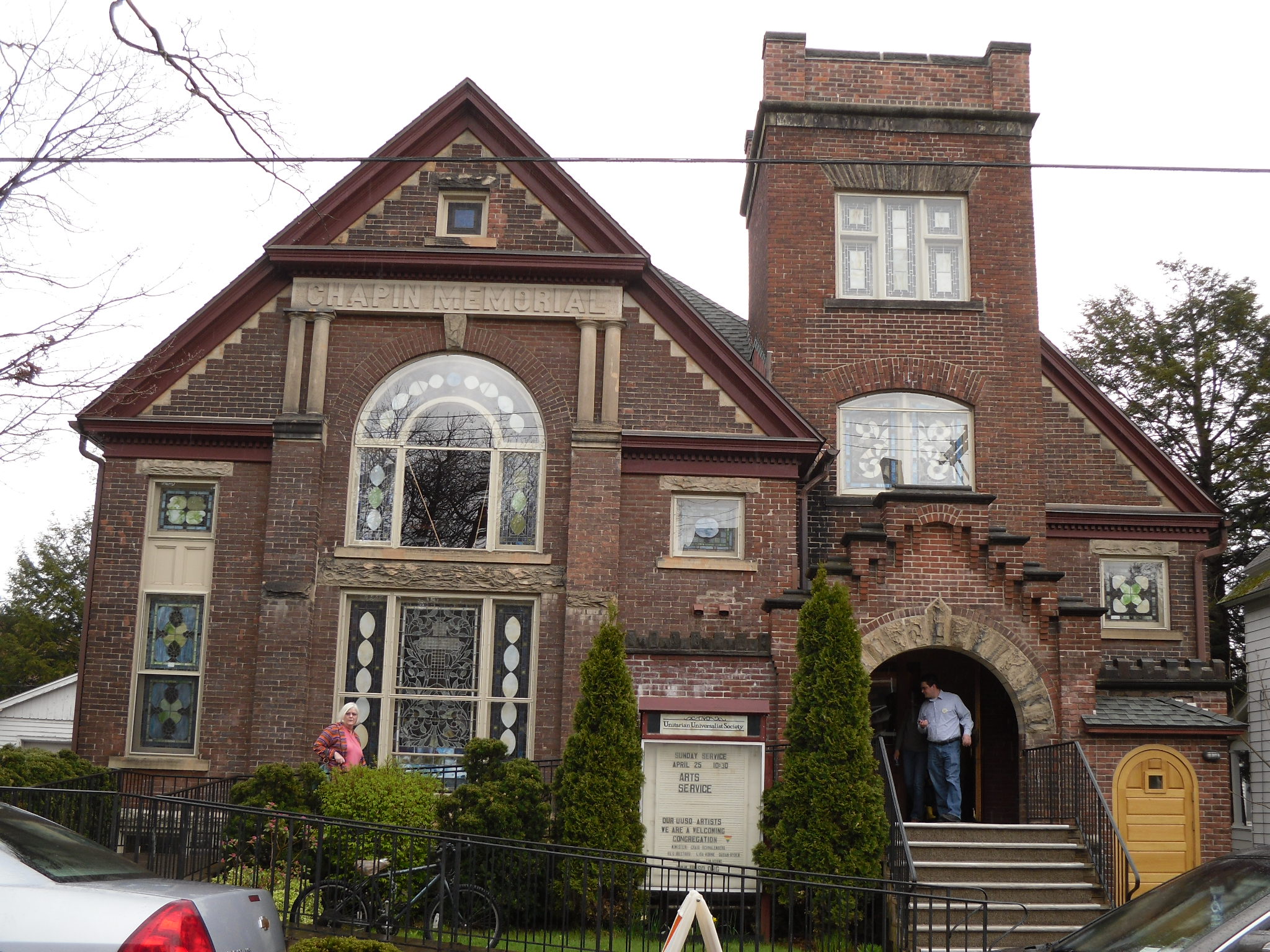
42°27′31″N 75°04′20″W / 42.458611°N 75.072222°WOneonta 6 Chapin Memorial Church 
September 12, 2002 12 Ford Ave.
42°42′24″N 74°58′36″W / 42.706667°N 74.976667°WOneonta 7 Cherry Valley Village Historic District 
April 28, 1988 Roughly bounded by Alden St. and Montgomery St., Maple Ave. and Elm St., and Main St.
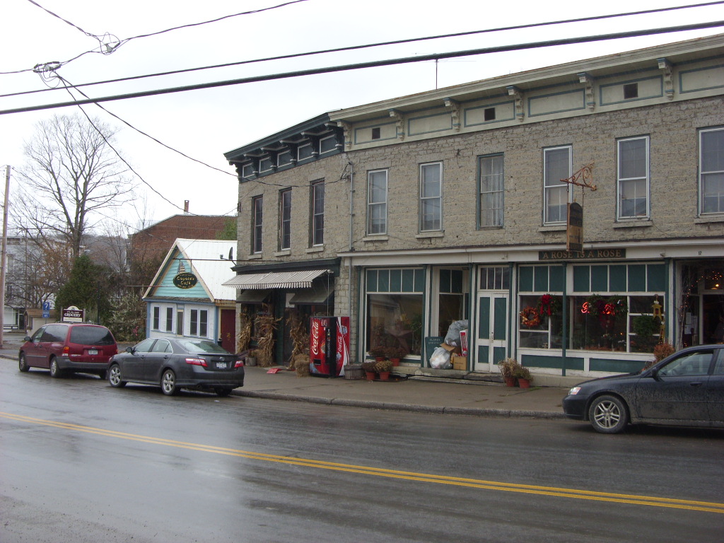
42°47′48″N 74°45′09″W / 42.796667°N 74.7525°WCherry Valley Boundary increase of 9,105 acres (36.85 km2) added as Lindesay Patent Rural Historic District in 1995 (NRHP Reference#: 95001024). 8 Church Street Historic District June 4, 1997 Roughly bounded by Church, Sylvan, Gould, and Warren Sts.
42°51′21″N 74°59′02″W / 42.855833°N 74.983889°WRichfield Springs 9 Cooperstown Historic District 
November 18, 1980 NY 28, NY 80 and Main St.
42°42′07″N 74°55′32″W / 42.701944°N 74.925556°WCooperstown Boundary increase to include Fenimore Farm Stone Agricultural Buildings in 1997 (NRHP Reference#: 97000937). 10 The Cornfield September 12, 2002 655 Cty Rd. 26
42°27′21″N 75°03′42″W / 42.455833°N 75.061667°WFly Creek 11 East Main Street Historic District 
November 7, 1995 Roughly, E. Main St. from Church St. to the Richfield Springs reservoirs
42°51′08″N 74°58′33″W / 42.852164°N 74.975903°WRichfield Springs 12 East Springfield Union School April 26, 1996 Approximately .5 mi (8.0 km). E of jct. of US 20 and Co. Rd. 31
42°49′49″N 74°48′45″W / 42.830278°N 74.8125°WEast Springfield 13 Fairchild Mansion February 12, 1974 318 Main St.
42°27′21″N 75°03′34″W / 42.455833°N 75.059444°WOneonta 14 Fly Creek Grange No. 844 February 25, 2004 208 Cemetery Rd.
42°43′00″N 74°59′02″W / 42.716667°N 74.983889°WFly Creek 15 Fly Creek Historic District 
November 8, 2006 NY 28, NY 80, cty Rd. 26, Cemetery Rd., Goose St. Allison Rd., Bissell Rd.
42°43′11″N 74°58′38″W / 42.719722°N 74.977222°WFly Creek 16 Fly Creek Methodist Church 
August 8, 1996 Co. Rt. 26, N of jct. with NY 28
42°43′09″N 74°58′59″W / 42.719167°N 74.983056°WFly Creek 17 Ford Block September 7, 1984 188-202 Main St.
42°27′14″N 75°03′43″W / 42.453889°N 75.061944°WOneonta 18 Fortin Site 
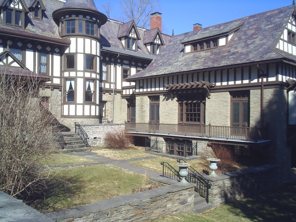
November 28, 1980 Address Restricted Oneonta 19 Gilbertsville Historic District May 17, 1974 Originally roughly bounded by Marion Ave., Cliff and Green Sts., Grover and Sylvan Sts.; later extended to approximate village borders
42°28′16″N 75°19′38″W / 42.471111°N 75.327222°WGilbertsville Boundary increase in 1982 (NRHP Reference#: 82001232). 20 Gilbertsville Water Works Gilbertsville Water WorksMay 18, 2011 Reservoir Rd. Gilbertsville vicinity New listing; refnum 11000290 21 Glimmerglass Historic District September 24, 1999 Otsego Lake and Environs
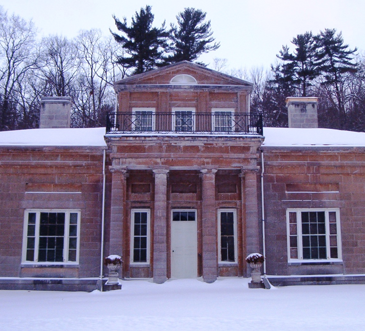
42°45′20″N 74°54′24″W / 42.755556°N 74.906667°WCooperstown 22 Hyde Hall 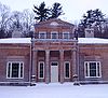
October 7, 1971 S of Springfield Center in Glimmerglass State Park
42°47′38″N 74°52′25″W / 42.793889°N 74.873611°WSpringfield Center 23 Hyde Hall Covered Bridge 
December 17, 1998 East Lake Rd., over Shadow Brook
42°47′25″N 74°51′50″W / 42.790278°N 74.863889°WEast Springfield 24 Kenyon Residences February 26, 2004 60 and 62 Main St.
42°34′45″N 75°03′30″W / 42.579167°N 75.058333°WMt. Vision 25 Lunn-Musser Octagon Barn September 29, 1984 S of Garrattsville
42°37′39″N 75°09′26″W / 42.6275°N 75.157222°WGarrattsville 26 Major's Inn and Gilbert Block 
April 11, 1973 Both sides of Commercial St. near NY 51
42°28′17″N 75°19′39″W / 42.471389°N 75.3275°WGilbertsville 27 Andrew Mann Inn January 10, 1980 33 Riverside Rd.
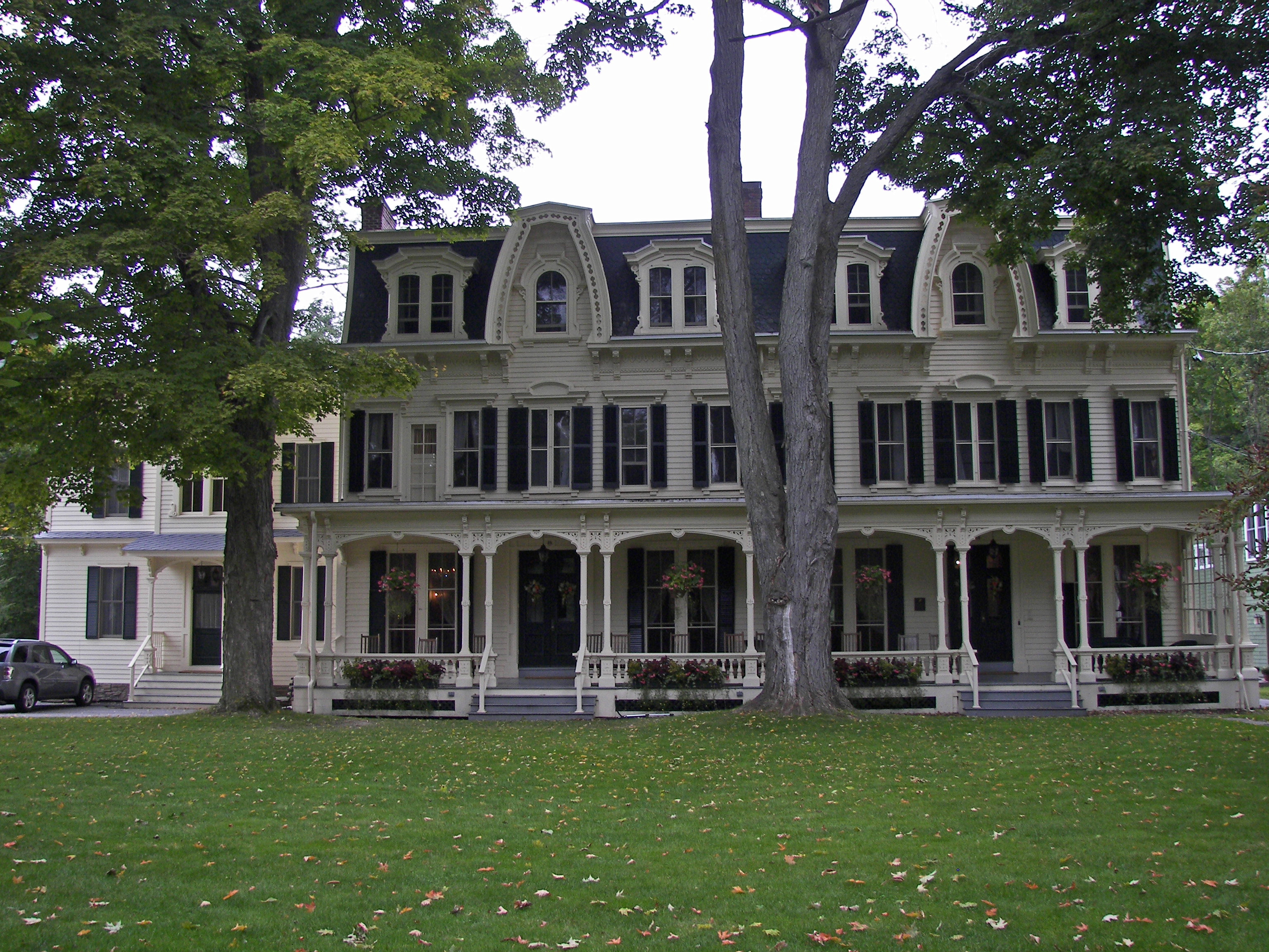
42°19′14″N 75°23′28″W / 42.320556°N 75.391111°WUnadilla 28 Middlefield District No. 1 School August 13, 1987 CR 35
42°41′23″N 74°49′46″W / 42.689722°N 74.829444°WCooperstown 29 Middlefield Hamlet Historic District 
July 11, 1985 CR 35, Rezen, Whiteman, and Long Patent Rds.
42°41′14″N 74°50′29″W / 42.687222°N 74.841389°WMiddlefield 30 Morris-Lull Farm December 7, 2005 133 Peet Rd.
42°31′24″N 75°14′57″W / 42.523333°N 75.249167°WMorris 31 Municipal Building October 29, 1982 238-242 Main St.
42°27′16″N 75°03′41″W / 42.454444°N 75.061389°WOneonta 32 Benjamin D. North House July 11, 1985 NY 166, The Plank Rd.
42°42′12″N 74°50′08″W / 42.703333°N 74.835556°WMiddlefield 33 Old Post Office 
November 17, 1978 Main St.
42°27′17″N 75°03′38″W / 42.454722°N 75.060556°WOneonta 34 Oneonta Armory March 2, 1995 4 Academy St.
42°27′03″N 75°03′56″W / 42.450833°N 75.065556°WOneonta 35 Oneonta Downtown Historic District December 4, 2003 Main, Chestnut, Dietz, Market, Elm, Water, Wall, S. Main Sts.
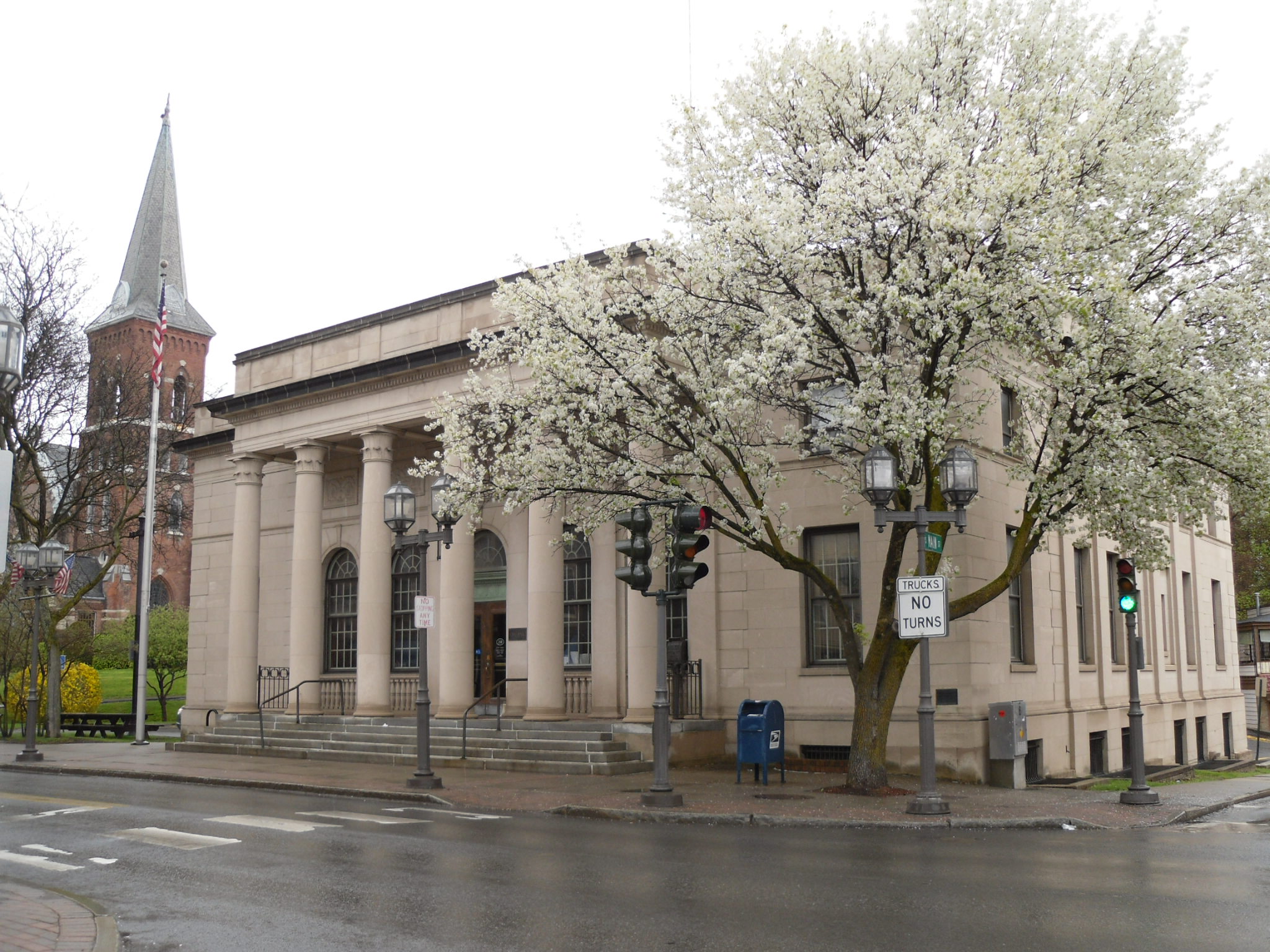
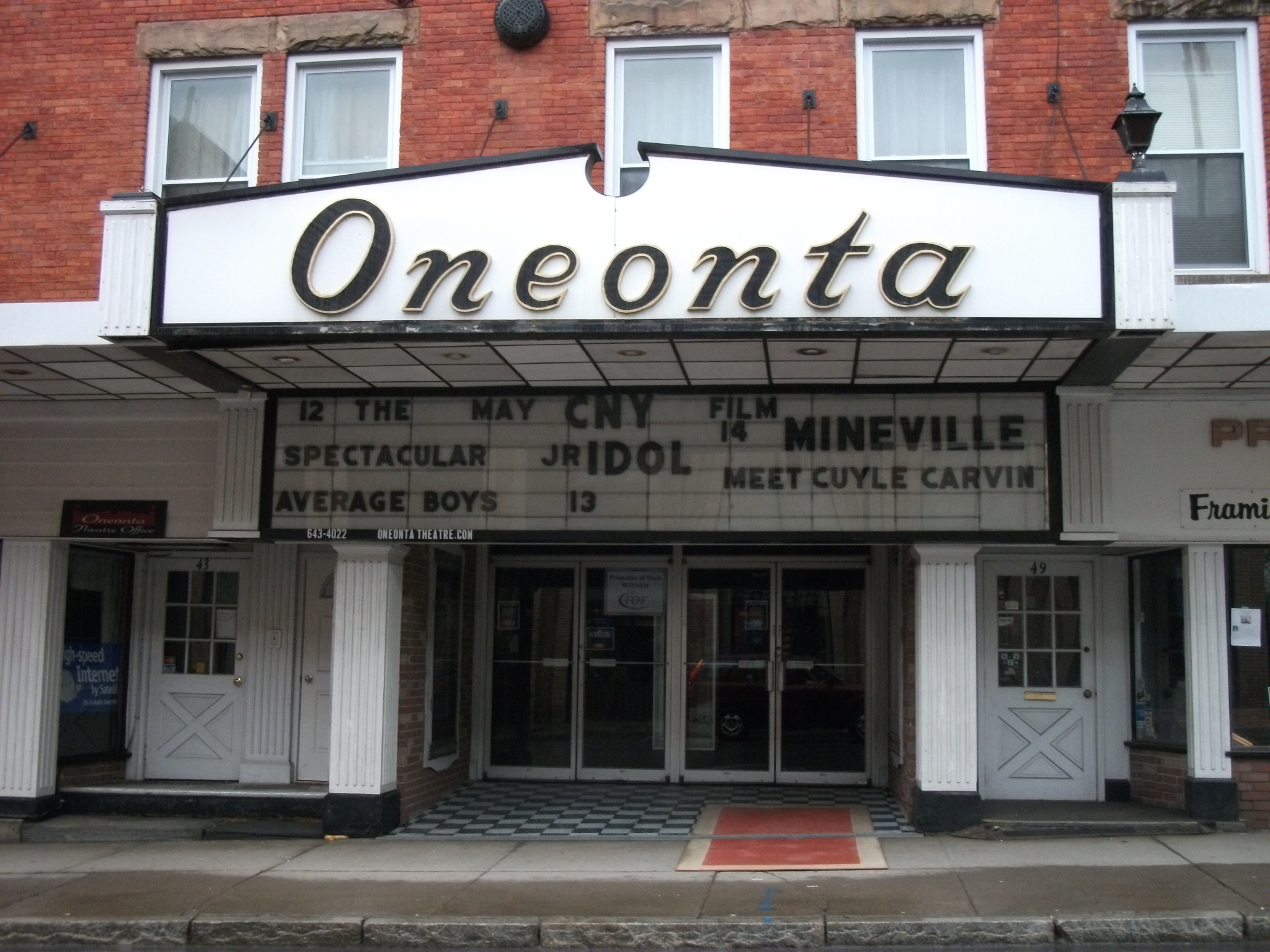
42°27′15″N 75°03′44″W / 42.454167°N 75.062222°WOneonta 36 Oneonta Theatre 
May 22, 2002 47 Chestnut St.
42°27′09″N 75°04′23″W / 42.4525°N 75.073056°WOneonta 37 Otsdawa Baptist Church March 6, 2002 Cty Rd. 8
42°29′11″N 75°10′25″W / 42.486389°N 75.173611°WOtsdawa 38 Otsdawa Creek Site July 22, 1980 Address Restricted Otego 39 Otsego County Courthouse June 20, 1972 193 Main St.
42°42′03″N 74°55′48″W / 42.700833°N 74.93°WCooperstown 40 Roseboom Historic District 
November 19, 1998 Roughly along NY 166, NY 165, Beaver, John Deer and Gage Rds.
42°44′21″N 74°46′16″W / 42.739167°N 74.771111°WRoseboom 41 Russ-Johnsen Site July 22, 1980 Address Restricted Unadilla 42 South Worcester Historic District 
November 5, 1992 Junction of County Route 40 and County Route 39 and west along Route 40
42°31′01″N 74°45′25″W / 42.516944°N 74.756944°WSouth Worcester 43 Springfield Center Elementary School Springfield Center Elementary SchoolAugust 24, 2011 129 County Road 29A
42°49′56″N 74°51′46″W / 42.832222°N 74.862778°WSpringfield Center New listing; refnum 11000601 44 Stonehouse Farm November 19, 1980 E of Oneonta on NY 7
42°28′14″N 75°00′08″W / 42.470556°N 75.002222°WOneonta 45 Sunnyside March 10, 1988 72 E. Main St.
42°51′07″N 74°58′42″W / 42.851944°N 74.978333°WRichfield Springs 46 Swart-Wilcox House May 24, 1990 Junction of Wilcox Ave. and Henry St.
42°26′38″N 75°04′15″W / 42.443889°N 75.070833°WOneonta 47 The Tepee The TepeeAugust 18, 2011 7632 US 20
42°48′28″N 74°41′04″W / 42.807778°N 74.684444°WCherry Valley vicinity New listing; refnum 11000543 48 Tianderah November 2, 1978 Off NY 51
42°27′50″N 75°18′54″W / 42.463889°N 75.315°WGilbertsville 49 Tunnicliff-Jordan House Tunnicliff-Jordan HouseSeptember 24, 2010 68–72 Main Street
42°51′09″N 74°58′38″W / 42.8525°N 74.977222°WRichfield Springs New listing; refnum 10000796 50 Twentieth Century Steam Riding Gallery No. 409 January 16, 1998 Race St.
42°32′48″N 74°49′37″W / 42.546667°N 74.826944°WSchenevus 51 Unadilla Forks School August 28, 1998 113 NY 18A
42°50′35″N 75°14′13″W / 42.843056°N 75.236944°WUnadilla Forks 52 Unadilla Village Historic District 
September 4, 1992 Roughly, Main St. from Hopkins St. to Butternut Rd. and Bridge St. fom Main to Watson St.
42°19′24″N 75°18′32″W / 42.323333°N 75.308889°WUnadilla 53 Unadilla Waterworks September 4, 1992 Jct. of Kilkenny Rd. and Clifton St. and jct. of Martin Brook Rd. and Rod & Gun Club Rd.
42°20′22″N 75°19′03″W / 42.339444°N 75.3175°WUnadilla 54 US Post Office-Cooperstown 
November 17, 1988 28-40 Main St.
42°42′01″N 74°55′24″W / 42.700278°N 74.923333°WCooperstown 55 US Post Office-Richfield Springs 
May 11, 1989 12 E. Main St.
42°51′11″N 74°59′07″W / 42.853056°N 74.985278°WRichfield Springs 56 Walnut Street Historic District July 30, 1980 Ford Ave., Walnut, Dietz, Elm and Maple Sts.
42°27′25″N 75°03′42″W / 42.456944°N 75.061667°WOneonta 57 West Burlington Memorial Church January 16, 2001 NY 80
42°42′25″N 75°11′16″W / 42.706944°N 75.187778°WWest Burlington 58 West Main Street-West James Street Historic District 
March 17, 1994 Roughly, along W. Main, W. James, Elm and Center Sts. and Taylor Ave.
42°51′12″N 74°59′19″W / 42.853333°N 74.988611°WRichfield Springs 59 George I. Wilber House November 15, 2000 11 Ford Ave.
42°27′19″N 75°03′43″W / 42.455278°N 75.061944°WOneonta 60 Women's Community Club of South Valley February 1, 1999 472 Kirshman Hill Rd.
42°42′21″N 74°42′40″W / 42.705833°N 74.711111°WSouth Valley 61 Worcester Historic District 
June 10, 1975 Both sides of Main St. (NY 7) between Decatur and Cook Sts.
42°35′31″N 74°45′00″W / 42.591944°N 74.75°WWorcester 62 Roswell Wright House 
September 1, 1988 25 Main St.
42°19′32″N 75°18′38″W / 42.325556°N 75.310556°WUnadilla 63 Zion Episcopal Church Complex and Harmony Cemetery 
November 24, 1997 East of Morris, NY 51
42°32′56″N 75°14′35″W / 42.548889°N 75.243056°WMorris See also
References
- ^ The latitude and longitude information provided in this table was derived originally from the National Register Information System, which has been found to be fairly accurate for about 99% of listings. For about 1% of NRIS original coordinates, experience has shown that one or both coordinates are typos or otherwise extremely far off; some corrections may have been made. A more subtle problem causes many locations to be off by up to 150 yards, depending on location in the country: most NRIS coordinates were derived from tracing out latitude and longitudes off of USGS topographical quadrant maps created under the North American Datum of 1927, which differs from the current, highly accurate WGS84 GPS system used by Google maps. Chicago is about right, but NRIS longitudes in Washington are higher by about 4.5 seconds, and are lower by about 2.0 seconds in Maine. Latitudes differ by about 1.0 second in Florida. Some locations in this table may have been corrected to current GPS standards.
- ^ "National Register of Historic Places: Weekly List Actions". National Park Service, United States Department of the Interior. Retrieved on November 18, 2011.
- ^ Numbers represent an ordering by significant words. Various colorings, defined here, differentiate National Historic Landmark sites and National Register of Historic Places Districts from other NRHP buildings, structures, sites or objects.
Categories:- National Register of Historic Places in New York by county
- Buildings and structures in Otsego County, New York
-


Wikimedia Foundation. 2010.