- National Register of Historic Places listings in New Rochelle, New York
-
This is a list of the National Register of Historic Places entries in New Rochelle, New York. See also National Register of Historic Places listings in Westchester County, New York for all others in the county.
This is intended to be a complete list of properties and districts listed on the National Register of Historic Places in New Rochelle, New York. The locations of National Register properties and districts (at least for all showing latitude and longitude coordinates below) may be seen in a Google map by clicking on "Map of all coordinates".[1]
-
- This National Park Service list is complete through NPS recent listings posted November 18, 2011.[2]
Contents: Counties in New York Albany (Albany) – Allegany – Bronx – Broome – Cattaraugus – Cayuga – Chautauqua – Chemung – Chenango – Clinton – Columbia – Cortland – Delaware – Dutchess – Erie (Buffalo) – Essex – Franklin – Fulton – Genesee – Greene – Hamilton – Herkimer – Jefferson – Kings (Brooklyn) – Lewis – Livingston – Madison – Monroe (Rochester) – Montgomery – Nassau – New York (Manhattan – Below 14th Street, 14th to 59th Streets, 59th to 110th Streets, Above 110th Street, Islands) – Niagara – Oneida – Onondaga (Syracuse) – Ontario – Orange – Orleans – Oswego – Otsego – Putnam – Queens – Rensselaer – Richmond (Staten Island) – Rockland – Saratoga – Schenectady – Schoharie – Schuyler – Seneca – St. Lawrence – Steuben – Suffolk – Sullivan – Tioga – Tompkins – Ulster – Warren – Washington – Wayne – Westchester (New Rochelle, Peekskill, Yonkers) – Wyoming – Yates Current listings
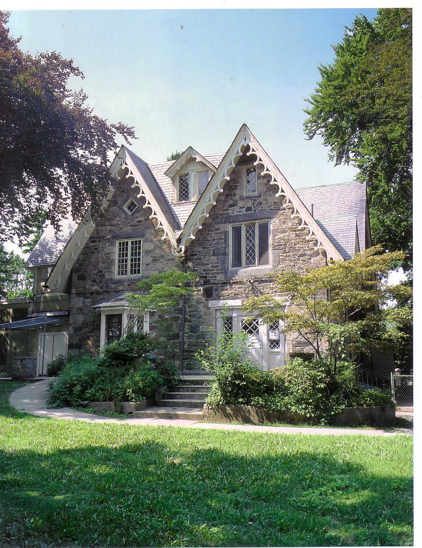
Landmark name Image Date listed Location City, Town or Village Summary 1 Davenport House 
April 30, 1980 157 Davenport Rd.
40°54′5″N 73°46′17″W / 40.90139°N 73.77139°WNew Rochelle Gothic Revival style cottage designed by influential architect Alexander Jackson Davis; built in 1859 2 First Presbyterian Church and Lewis Pintard House 
September 7, 1979 Pintard Ave.
40°54′16″N 73°47′7″W / 40.90444°N 73.78528°WNew Rochelle 3 Knickerbocker Press Building 
May 11, 2000 50-52 Webster Ave.
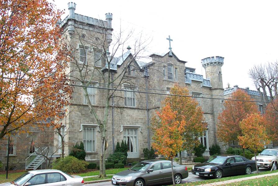
40°54′17″N 73°47′29″W / 40.90472°N 73.79139°WNew Rochelle 4 Leland Castle 
August 27, 1976 29 Castle Pl.
40°53′52″N 73°46′53″W / 40.89778°N 73.78139°WNew Rochelle 5 Lispenard-Rodman-Davenport House 
September 22, 1986 180 Davenport Ave.
40°54′4″N 73°46′17″W / 40.90111°N 73.77139°WNew Rochelle 6 New Rochelle Railroad Station 
October 14, 2009 Between N. Ave. and Memorial Hwy.
40°54′44.34″N 73°47′5.77″W / 40.9123167°N 73.7849361°WNew Rochelle New listing; refnum 09000837 7 Thomas Paine Cottage 
November 28, 1972 20 Sicard Ave.
40°56′1″N 73°47′29″W / 40.93361°N 73.79139°WNew Rochelle Home of Thomas Paine, author of "Common Sense", and other Revolutionary pamphlets. 8 Pioneer Building 
December 29, 1983 14 Lawton St.
40°54′36″N 73°46′56″W / 40.91°N 73.78222°WNew Rochelle 9 Rochelle Park-Rochelle Heights Historic District July 6, 2005 The Circle, The Boulevard, The Serpentine, Hamilton Ave. and others
40°55′29″N 73°46′50″W / 40.92472°N 73.78056°WNew Rochelle 10 Trinity-St. Paul's Episcopal Church 
July 12, 2006 311 Huguenot St.
40°54′41″N 73°47′5″W / 40.91139°N 73.78472°WNew Rochelle 11 US Post Office-New Rochelle 
May 11, 1989 255 North Ave.
40°54′41″N 73°46′56″W / 40.91139°N 73.78222°WNew Rochelle 12 Wildcliff 
December 31, 2002 42 Wildcliff Rd.
40°54′23″N 73°46′12″W / 40.90639°N 73.77°WNew Rochelle See also
- National Register of Historic Places listings in New York
- National Register of Historic Places listings in Westchester County, New York
References
- ^ The latitude and longitude information provided in this table was derived originally from the National Register Information System, which has been found to be fairly accurate for about 99% of listings. For about 1% of NRIS original coordinates, experience has shown that one or both coordinates are typos or otherwise extremely far off; some corrections may have been made. A more subtle problem causes many locations to be off by up to 150 yards, depending on location in the country: most NRIS coordinates were derived from tracing out latitude and longitudes off of USGS topographical quadrant maps created under the North American Datum of 1927, which differs from the current, highly accurate WGS84 GPS system used by Google maps. Chicago is about right, but NRIS longitudes in Washington are higher by about 4.5 seconds, and are lower by about 2.0 seconds in Maine. Latitudes differ by about 1.0 second in Florida. Some locations in this table may have been corrected to current GPS standards.
- ^ "National Register of Historic Places: Weekly List Actions". National Park Service, United States Department of the Interior. Retrieved on November 18, 2011.
Categories:- New Rochelle, New York
- National Register of Historic Places in Westchester County, New York
-


Wikimedia Foundation. 2010.