- National Register of Historic Places listings in Cortland County, New York
-
 Location of Cortland County in New York
List of the National Register of Historic Places listings in Cortland County, New York:
This is intended to be a complete list of properties and districts listed on the National Register of Historic Places in Cortland County, New York. The locations of National Register properties and districts (at least for all showing latitude and longitude coordinates below) may be seen in a Google map by clicking on "Map of all coordinates".[1]
-
- This National Park Service list is complete through NPS recent listings posted November 18, 2011.[2]
Contents: Counties in New York Albany (Albany) – Allegany – Bronx – Broome – Cattaraugus – Cayuga – Chautauqua – Chemung – Chenango – Clinton – Columbia – Cortland – Delaware – Dutchess – Erie (Buffalo) – Essex – Franklin – Fulton – Genesee – Greene – Hamilton – Herkimer – Jefferson – Kings (Brooklyn) – Lewis – Livingston – Madison – Monroe (Rochester) – Montgomery – Nassau – New York (Manhattan – Below 14th Street, 14th to 59th Streets, 59th to 110th Streets, Above 110th Street, Islands) – Niagara – Oneida – Onondaga (Syracuse) – Ontario – Orange – Orleans – Oswego – Otsego – Putnam – Queens – Rensselaer – Richmond (Staten Island) – Rockland – Saratoga – Schenectady – Schoharie – Schuyler – Seneca – St. Lawrence – Steuben – Suffolk – Sullivan – Tioga – Tompkins – Ulster – Warren – Washington – Wayne – Westchester (New Rochelle, Peekskill, Yonkers) – Wyoming – Yates Listings county-wide
[3] Landmark name Image Date listed Location City or town Summary 1 Cincinnatus Historic District September 7, 1984 Main St. and Taylor Ave.
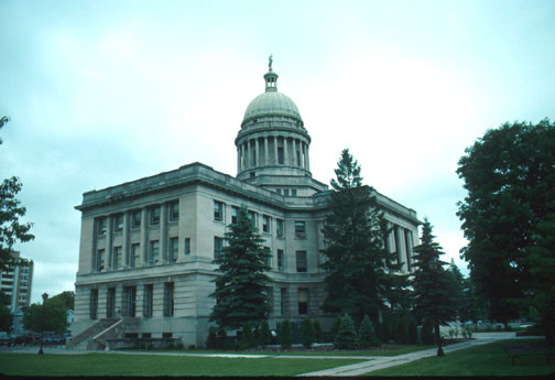
42°32′31″N 75°54′16″W / 42.541944°N 75.904444°WCincinnatus Historic district in this very small town 2 Cortland County Courthouse 
October 9, 1974 Courthouse Park
42°35′56″N 76°10′37″W / 42.598889°N 76.176944°WCortland 3 Cortland County Poor Farm October 29, 1982 NE of Cortland off NY 13
42°37′36″N 76°08′14″W / 42.626667°N 76.137222°WCortland 4 Cortland Fire Headquarters July 12, 1974 21 Court St.
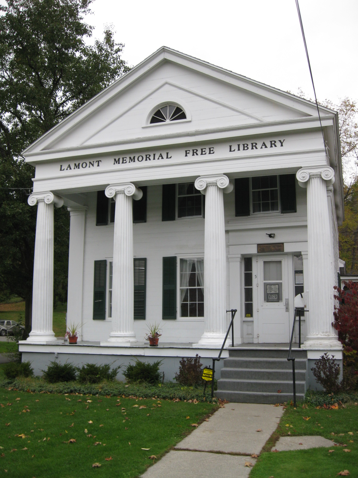
42°35′57″N 76°10′46″W / 42.599167°N 76.179444°WCortland 5 Cortland Free Library May 30, 2008 32 Church Street
42°35′59″N 76°10′41″W / 42.599853°N 76.177936°WCortland (new listing, refnum 08000469) 6 First Presbyterian Church January 24, 2002 Courtland Cty Rd. 108B
42°44′06″N 76°08′47″W / 42.735°N 76.146389°WPreble 7 First Presbyterian Church Complex 
March 6, 2002 23 Church St.
42°35′57″N 76°10′41″W / 42.599167°N 76.178056°WCortland 8 Glen Haven District No. 4 School and Public Library May 23, 1997 7325 Fair Haven Rd.
42°45′39″N 76°16′04″W / 42.760833°N 76.267778°WFair Haven 9 William J. Greenman House August 18, 2011 27 N. Church St.
42°36′15″N 76°10′40″W / 42.604167°N 76.177778°WCortland New listing; refnum 11000542 10 Hatheway Homestead 
January 20, 1978 NY 41
42°37′04″N 76°01′11″W / 42.617778°N 76.019722°WSolon 11 Little York Pavilion July 27, 1979 S of Preble off NY 281
42°42′37″N 76°09′11″W / 42.710278°N 76.153056°WPreble 12 Main Street Historic District 
September 25, 1986 Roughly on Main St. between South and Washington Sts.
42°35′46″N 76°05′35″W / 42.596111°N 76.093056°WMcGraw 13 Old Homer Village Historic District October 2, 1973 N.and S. Main St., Central Park, Clinton, James, Cayuga, and Albany Sts.
42°38′11″N 76°10′50″W / 42.636389°N 76.180556°WHomer 14 Peck Memorial Library May 19, 1992 28 E. Main St.
42°26′28″N 76°02′00″W / 42.441111°N 76.033333°WMarathon 15 Presbyterian Church of McGraw 
September 11, 1986 3 W. Main St.
42°35′44″N 76°05′45″W / 42.595556°N 76.095833°WMcGraw 16 Randall Farm June 2, 2000 3713 Page Green Rd.
42°35′06″N 76°10′49″W / 42.585°N 76.180278°WCortland 17 Stage Coach Inn Stage Coach InnDecember 11, 2009 2548 Clarks Corners Rd.
42°26′27″N 76°06′03″W / 42.440811°N 76.100972°WLapeer New listing; refnum 09001080 18 Tarbell Building November 22, 2000 2 Cortland St.
42°26′31″N 76°01′58″W / 42.441944°N 76.032778°WMarathon 19 Taylor Center Methodist Episcopal Church and Taylor District #3 School Taylor Center Methodist Episcopal Church and Taylor District #3 SchoolJuly 30, 2010 4332-4338 Cheningo-Solon Pond Rd.
42°36′59″N 75°55′32″W / 42.616389°N 75.925556°WTaylor Center New listing; refnum 10000515 20 Tompkins Street Historic District March 18, 1975 Tompkins and intersecting streets from Main St. to Cortland Rural Cemetery
42°35′43″N 76°11′12″W / 42.595278°N 76.186667°WCortland 21 Town Line Bridge May 29, 2008 Town Line Rd. Taylor (new listing; refnum 08000470) 22 Truxton Depot September 25, 2008 Railroad St.
42°42′31″N 76°01′49″W / 42.708611°N 76.030278°WTruxton {new listing; refnum 08000930 23 Union Valley Congregational Church December 31, 2002 Union Valley Cross Rd.
42°38′01″N 75°53′00″W / 42.633611°N 75.883333°WTaylor 24 Unitarian Universalist Church 
July 1, 1993 3 Church St.
42°36′05″N 76°10′41″W / 42.601389°N 76.178056°WCortland Cobblestone church 25 US Post Office-Cortland November 17, 1988 88 Main St.
42°35′54″N 76°10′51″W / 42.598333°N 76.180833°WCortland 26 US Post Office-Homer 
May 11, 1989 2 S. Main St.
42°38′44″N 76°10′46″W / 42.645556°N 76.179444°WHomer 27 Water, Wall, and Pine Streets Lenticular Truss Bridges October 5, 1977 Wall, Water and Pine Sts.
42°38′15″N 76°10′36″W / 42.6375°N 76.176667°WHomer See also
References
- ^ The latitude and longitude information provided in this table was derived originally from the National Register Information System, which has been found to be fairly accurate for about 99% of listings. For about 1% of NRIS original coordinates, experience has shown that one or both coordinates are typos or otherwise extremely far off; some corrections may have been made. A more subtle problem causes many locations to be off by up to 150 yards, depending on location in the country: most NRIS coordinates were derived from tracing out latitude and longitudes off of USGS topographical quadrant maps created under North American Datum of 1927, which differs from the current, highly accurate GPS system used by Google maps. Chicago is about right, but NRIS longitudes in Washington are higher by about 4.5 seconds, and are lower by about 2.0 seconds in Maine. Latitudes differ by about 1.0 second in Florida. Some locations in this table may have been corrected to current GPS standards.
- ^ "National Register of Historic Places: Weekly List Actions". National Park Service, United States Department of the Interior. Retrieved on November 18, 2011.
- ^ Numbers represent an ordering by significant words. Various colorings, defined here, differentiate National Historic Landmark sites and National Register of Historic Places Districts from other NRHP buildings, structures, sites or objects.
Categories:- Cortland County, New York
- National Register of Historic Places in New York by county
-


Wikimedia Foundation. 2010.