- National Register of Historic Places listings in Hamilton County, New York
-
 Location of Hamilton County in New York
List of the National Register of Historic Places listings in Hamilton County, New York
This is intended to be a complete list of properties and districts listed on the National Register of Historic Places in Hamilton County, New York. The locations of National Register properties and districts (at least for all showing latitude and longitude coordinates below) may be seen in a Google map by clicking on "Map of all coordinates".[1] Two sites are further designated National Historic Landmarks and the entire county is included in another, the Adirondack Forest Preserve.
-
- This National Park Service list is complete through NPS recent listings posted November 18, 2011.[2]
Contents: Counties in New York Albany (Albany) – Allegany – Bronx – Broome – Cattaraugus – Cayuga – Chautauqua – Chemung – Chenango – Clinton – Columbia – Cortland – Delaware – Dutchess – Erie (Buffalo) – Essex – Franklin – Fulton – Genesee – Greene – Hamilton – Herkimer – Jefferson – Kings (Brooklyn) – Lewis – Livingston – Madison – Monroe (Rochester) – Montgomery – Nassau – New York (Manhattan – Below 14th Street, 14th to 59th Streets, 59th to 110th Streets, Above 110th Street, Islands) – Niagara – Oneida – Onondaga (Syracuse) – Ontario – Orange – Orleans – Oswego – Otsego – Putnam – Queens – Rensselaer – Richmond (Staten Island) – Rockland – Saratoga – Schenectady – Schoharie – Schuyler – Seneca – St. Lawrence – Steuben – Suffolk – Sullivan – Tioga – Tompkins – Ulster – Warren – Washington – Wayne – Westchester (New Rochelle, Peekskill, Yonkers) – Wyoming – Yates Listings county-wide
[3] Landmark name Image Date listed Location City or town Summary 1 Adirondack Forest Preserve 
October 15, 1966 NE New York State
43°58′43″N 74°18′42″W / 43.978611°N 74.311667°WAll of Hamilton County is in the 6-million-acre (24,000 km2) Adirondack Park. 2 Blue Mountain Fire Observation Station 
September 23, 2001 Blue Mountain
43°52′02″N 74°25′50″W / 43.867222°N 74.430556°WTown of Indian Lake 3 Blue Mountain House Annex 
December 7, 1977 NY 30
43°51′19″N 74°26′02″W / 43.855278°N 74.433889°WBlue Mountain Lake Also known as The Log Hotel, on the grounds of the Adirondack Museum 4 Camp Pine Knot 
November 7, 1986 Long Point, Raquette Lake
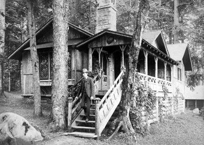
43°49′17″N 74°37′34″W / 43.821389°N 74.626111°WRaquette Lake Pine Knot was the first of the Adirondack Great Camps; it was started beginning in 1877 by railroad developer Thomas C. Durant, and completed by William West Durant. It was sold to industrialist Collis P. Huntington in 1890. 5 Camp Uncas 
April 3, 1987 Mohegan Lake
43°44′41″N 74°38′53″W / 43.744722°N 74.648056°WRaquette Lake The second Adirondack Great Camp built by William West Durant for his own use, after Camp Pine Knot. It was sold to J. Pierpont Morgan in 1896. 6 Church of the Transfiguration 
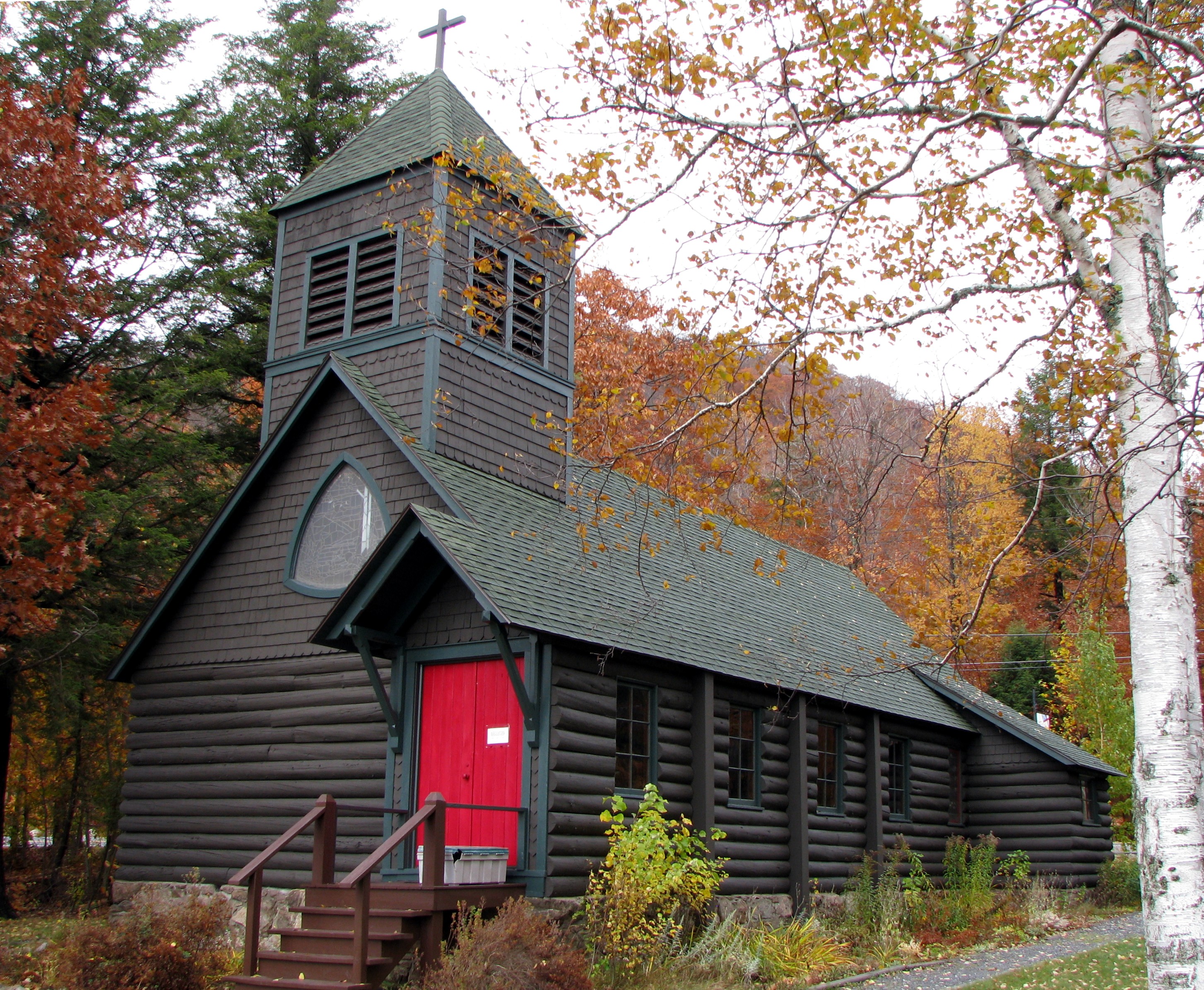
July 26, 1977 N of Blue Mountain Lake on NY 30
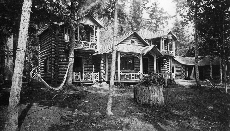
43°51′34″N 74°25′55″W / 43.859444°N 74.431944°WBlue Mountain Lake 1881 log church, possibly the only surviving log church in the Adirondacks, with a Meneely bell donated by Mrs. [[Levi P. Morton] wife of future Vice-President under Benjamin Harrison 1889-1893]]. 7 Echo Camp 
November 7, 1986 Long Point, Raquette Lake
43°49′26″N 74°38′08″W / 43.823889°N 74.635556°WRaquette Lake An Adirondack Great Camp built for Connecticut governor Phineas C. Lounsbury in 1883, its design bears the influence of William West Durant. 8 Hamilton County Courthouse Complex September 24, 1992 Jct. of NY 8 and S. Shore Rd.
43°28′13″N 74°24′45″W / 43.470278°N 74.4125°WLake Pleasant 9 The Hedges 
March 27, 2009 The Hedges
43°51′15″N 74°27′00″W / 43.854167°N 74.45°WBlue Mountain Lake New listing; refnum 09000155 10 Lake Pleasant Town Hall April 23, 2009 2885 NY 8
43°30′02″N 74°21′56″W / 43.500556°N 74.365556°WSpeculator New listing; refnum #09000238 11 New York Central Railroad Adirondack Division Historic District 
December 23, 1993 NYCRR Right-of-Way
44°00′00″N 74°46′32″W / 44.0°N 74.775556°WNehasane The New York Central passed through Nehasane and Sabattis; the station at Nehesane on Lake Lila is extant. 12 Pillsbury Mountain Forest Fire Observation Station Pillsbury Mountain Forest Fire Observation StationSeptember 9, 2010 Pillsbury Mountain
43°34′51″N 74°30′41″W / 43.580833°N 74.511389°WArietta vicinity New listing from Fire Observation Stations of New York State Forest Preserve MPS; refnum 10000728 13 Sagamore 
January 11, 1976 Off NY 28 at W end of Sagamore Lake
43°45′56″N 74°37′38″W / 43.765556°N 74.627222°WRaquette Lake The third Adirondack Great Camp constructed by William West Durant on Sagamore Lake between 1895–1897; it was later sold to Alfred Gwynne Vanderbilt. 14 Snowy Mountain Fire Observation Station September 23, 2001 Snowy Mountain
43°42′07″N 74°20′06″W / 43.701944°N 74.335°WIndian Lake 15 St. William's Catholic Church 
January 7, 2005 Long Point on Raquette Lake
43°49′33″N 74°37′55″W / 43.825833°N 74.631944°WLong Lake 16 Wakely Mountain Fire Observation Station October 3, 2003 Wakely Mountain
43°43′50″N 74°28′25″W / 43.730556°N 74.473611°WLake Pleasant 17 Wells Baptist Church September 1, 1988 Main St.
43°24′02″N 74°17′16″W / 43.400556°N 74.287778°WWells 18 Whelan Camp December 21, 1989 Mick Rd.
43°48′27″N 74°39′13″W / 43.8075°N 74.653611°WLong Lake See also
- National Register of Historic Places listings in New York
- List of National Historic Landmarks in New York
References
- ^ The latitude and longitude information provided in this table was derived originally from the National Register Information System, which has been found to be fairly accurate for about 99% of listings. For about 1% of NRIS original coordinates, experience has shown that one or both coordinates are typos or otherwise extremely far off; some corrections may have been made. A more subtle problem causes many locations to be off by up to 150 yards, depending on location in the country: most NRIS coordinates were derived from tracing out latitude and longitudes off of USGS topographical quadrant maps created under the North American Datum of 1927, which differs from the current, highly accurate WGS84 GPS system used by Google maps. Chicago is about right, but NRIS longitudes in Washington are higher by about 4.5 seconds, and are lower by about 2.0 seconds in Maine. Latitudes differ by about 1.0 second in Florida. Some locations in this table may have been corrected to current GPS standards.
- ^ "National Register of Historic Places: Weekly List Actions". National Park Service, United States Department of the Interior. Retrieved on November 18, 2011.
- ^ Numbers represent an ordering by significant words. Various colorings, defined here, differentiate National Historic Landmark sites and National Register of Historic Places Districts from other NRHP buildings, structures, sites or objects.
Categories:- National Register of Historic Places in New York by county
- Hamilton County, New York
-


Wikimedia Foundation. 2010.