- New York State Route 51
-
This article is about the current alignment of NY 51. For the former alignment of NY 51 in Delaware County, see New York State Route 51 (1920s–1930).
NYS Route 51
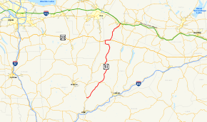
Map of central New York with NY 51 highlighted in redRoute information Maintained by NYSDOT Length: 55.02 mi[2] (88.55 km) Existed: 1930[1] – present Major junctions South end:  NY 8 in Guilford
 US 20 in West Winfield
North end:  NY 5 in Herkimer
Location Counties: Chenango, Otsego, Herkimer Highway system Numbered highways in New York
Interstate • U.S. • N.Y. (former) • Reference • County←  NY 50
NY 50NY 52  →
→New York State Route 51 (NY 51) is a state highway in the central part of New York state. The highway runs generally in a southwest to northeast direction from the hamlet of Mount Upton to the village of Ilion. NY 51 is a two-lane highway its entire length.
As NY 51 approaches the northern border of Otsego County, it makes a sharp left before descending to US 20 to the west in West Winfield. A 2.8-mile (4.5 km) concurrency carries it back to the original path where it again heads northward. Then, at Cedarville, it turns left and then right to use a different route, from thence it descends through the winding Ilion Gorge until it reaches Ilion, where it is known as Otsego Street.
After crossing the Mohawk River/Erie Canal, NY 51 ends at NY 5 at a trumpet interchange.
Contents
Route description
Chenango and Otsego Counties
NY 51 begins at an intersection with NY 8 in Mount Upton as Bridge St, just inside the Chenango County line. The route heads east from the intersection and enters Otsego County a mere 0.12 miles (0.19 km) later upon crossing the Unadilla River.[2]
Once in Otsego County, NY 51 enters the town of Butternuts. NY 51 continues through Copes Corners, passing by the Gilbertsville-Mount Upton Central School. NY 51 continues to the northeast, eventually heading into the village of Gilbertsville as Marian Ave. NY 51 soon leaves Gilbertsville, continuing its northeasterly direction. About 2 miles (3.2 km) later, NY 51 enters the town of Morris. NY 51 continues for a few more miles through rural areas, eventually entering the village of Morris as Main St. NY 51 intersects with NY 23 in the village of Morris. NY 51 then continues northeast as it leaves the village of Morris. NY 51 soon enters the town of New Lisbon. NY 51 travels through mostly rural land. It passes through the hamlet of Garrattsville, where it bends to a more northerly direction.
NY 51 then soon enters the town of Burlington and the hamlet of West Burlington. At this point, NY 51 joins NY 80 northeastward to Barrett Corners. Here, NY 51 returns to the north and passes through the hamlets of Burlington Flats and West Exeter on its way northward into Herkimer County.
Herkimer County
North of the county line in the village of West Winfield, NY 51 meets U.S. Route 20. The two routes join here, overlapping for about 3 miles (5 km) to East Winfield, where NY 51 forks from US 20 and continues northward once more. It passes through the hamlet of Cedarville and Ilion Gorge on its way into the village of Ilion. Here, NY 51 intersects with NY 5S before crossing the Mohawk River (Erie Canal) into the town of Herkimer, where it ends at an interchange with NY 5.
History
In 1908, the New York State Legislature created Route 23, an unsigned legislative route extending from Ilion to the North Country via West Winfield and Utica. The route began at Route 6 (later NY 5S and now Clark Street) in Ilion and followed what is now NY 51 southwest to West Winfield. At the center of the village, Route 23 continued west toward Utica on modern U.S. Route 20.[3][4] In 1912, Route 23 was truncated to begin at the western village line of West Winfield while the portion of the route east of that point became Route 23-a.[4] The change was reverted on March 1, 1921, moving the start of Route 23 back to Ilion.[5]
In the mid-1920s, the segment of modern NY 51 between West Burlington and West Winfield was designated as part of NY 44, a route that extended south from West Burlington to Sidney and north from West Winfield to Utica. At the time, this was the only substantial segment of what is now NY 51 to have a route number even though all of modern NY 51 south of Ilion was state-maintained.[6][7] In the 1930 renumbering of state highways in New York, most of NY 44 became part of NY 8. The section from West Burlington to West Winfield, however, became part of the new NY 51,[1] which utilized all of its modern routing from Mount Upton to Ilion upon assignment.[8] It was extended across the Mohawk River to NY 5 in North Ilion in the mid-1960s.[9][10]
Major intersections
County Location Mile[2] Destinations Notes Chenango Guilford 0.00 NY 8Hamlet of Mount Upton Otsego Village of Morris 11.55  NY 23 west
Western terminus of NY 23 / NY 51 overlap 12.03 NY 23 eastEastern terminus of NY 23 / NY 51 overlap Burlington 25.00  NY 80 west
Hamlet of West Burlington; western terminus of NY 51 / NY 80 overlap 26.06 NY 80 eastEastern terminus of NY 51 / NY 80 overlap Herkimer West Winfield 40.16 US 20 westWestern terminus of US 20 / NY 51 overlap Town of Winfield 43.00 US 20 eastEastern terminus of US 20 / NY 51 overlap Ilion 54.54 Clark Street Former routing of NY 5S 54.86  NY 5S
NY 5SInterchange Town of Herkimer 55.02 NY 5Trumpet interchange 1.000 mi = 1.609 km; 1.000 km = 0.621 mi References
- ^ a b Dickinson, Leon A. (January 12, 1930). "New Signs for State Highways". The New York Times: p. 136.
- ^ a b c "2008 Traffic Volume Report for New York State" (PDF). New York State Department of Transportation. June 16, 2009. pp. 115–116. https://www.nysdot.gov/divisions/engineering/technical-services/hds-respository/NYSDOT%20TVR%202008%20by%20Route.pdf. Retrieved January 31, 2010.
- ^ . Albany, New York: J. B. Lyon Company. 1908. p. 61. http://books.google.com/books?id=&pg=PA61. Retrieved June 25, 2010.
- ^ a b New York State Department of Highways (1920). Report of the State Commissioner of Highways. Albany, New York: J. B. Lyon Company. pp. 534–535. http://books.google.com/books?id=Sj4CAAAAYAAJ&pg=PA534. Retrieved June 25, 2010.
- ^ New York State Legislature (1921). "Tables of Laws and Codes Amended or Repealed". Laws of the State of New York passed at the One Hundred and Forty-Fourth Session of the Legislature. Albany, New York: J. B. Lyon Company. pp. 42, 60–61. http://books.google.com/books?id=6pE4AAAAIAAJ&pg=PA42. Retrieved June 25, 2010.
- ^ "New York's Main Highways Designated by Numbers". The New York Times: p. XX9. December 21, 1924.
- ^ State of New York Department of Public Works (1926). Official Map Showing State Highways and other important roads (Map). Cartography by Rand McNally and Company.
- ^ Standard Oil Company of New York (1930). Road Map of New York (Map). Cartography by General Drafting.
- ^ Mobil (1965). New York (Map). Cartography by Rand McNally and Company.
- ^ Esso (1968). New York (Map). Cartography by General Drafting (1969–70 ed.).
External links
Categories:- State highways in New York
- Transportation in Chenango County, New York
- Transportation in Otsego County, New York
- Transportation in Herkimer County, New York


Wikimedia Foundation. 2010.