- North Yorkshire
-
For other uses, see Yorkshire North.
North Yorkshire 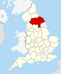
Geography Status Ceremonial & (smaller) Non-metropolitan county Origin 1974 Region Yorkshire and the Humber
(Part of the ceremonial county is in the North East Region)Area
- TotalRanked 1st
8,654 km2 (3,341 sq mi)Admin HQ Northallerton[1] ISO 3166-2 GB-NYK ONS code 36 NUTS 3 UKE22 Demography Population
- Total (2005)
- Density
- Admin. council
- Admin. pop.Ranked 16th
1,082,000
126 /km2 (330 /sq mi)
Ranked 19th
599,800Ethnicity 97.9% White
1.0% S.AsianPolitics 
North Yorkshire County Council
http://www.northyorks.gov.uk/Executive Conservative Members of Parliament - Nigel Adams (C)
- Hugh Bayley (L)
- Stuart Bell (L)
- Tom Blenkinsop (L)
- Robert Goodwill (C)
- William Hague (C)
- Andrew Jones (C)
- Anne McIntosh (C)
- Julian Smith (C)
- Julian Sturdy (C)
- Ian Swales (LD)
- James Wharton (C)
Districts 
- Selby
- Harrogate
- Craven
- Richmondshire
- Hambleton
- Ryedale
- Scarborough
- City of York (Unitary)
- Redcar and Cleveland (Unitary)
- Middlesbrough (Unitary)
- Stockton-on-Tees (Unitary)
(the part south of the Tees)
Neighbouring counties are: County Durham, East Riding of Yorkshire, Cumbria, Lancashire, South Yorkshire and West Yorkshire
North Yorkshire is a non-metropolitan or shire county located in the Yorkshire and the Humber region of England, and a ceremonial county primarily in that region but partly in North East England. Created in 1974 by the Local Government Act 1972[2] it covers an area of 8,654 square kilometres (3,341 sq mi), making it the largest ceremonial county in England. The majority of the Yorkshire Dales and all of the North York Moors lie within North Yorkshire's boundaries, and around 40% of the county is covered by National Parks.
Contents
Divisions and environs
The area under the control of the county council, or shire county, is divided into a number of local government districts; they are Craven, Hambleton, Harrogate, Richmondshire, Ryedale, Scarborough and Selby.[3]
The Department for Communities and Local Government did consider reorganising North Yorkshire County Council's administrative structure by abolishing the seven district councils and the county council to create a North Yorkshire unitary authority. The changes were planned to be implemented no later than 1 April 2009.[4][5] This was rejected on 25 July 2007 so the County Council and District Council structure will remain.[6]
The largest settlement in the administrative county is Harrogate, while in the ceremonial county it is York.
York, Middlesbrough and Redcar and Cleveland are unitary authority boroughs which form part of the ceremonial county for various functions such as the Lord Lieutenant of North Yorkshire, but do not come under county council control. Uniquely for a district in England, Stockton-on-Tees is split between North Yorkshire and County Durham for this purpose. Middlesbrough, Stockton-on-Tees, and Redcar and Cleveland boroughs form part of the North East England region.[7]
The ceremonial county area, including the unitary authorities, borders East Riding of Yorkshire, South Yorkshire, West Yorkshire, Lancashire, Cumbria and County Durham.
Physical features
The geology of North Yorkshire is closely reflected in its landscape. Within the county are the North York Moors and most of the Yorkshire Dales; two of eleven areas of countryside within England and Wales to be officially designated as national parks. Between the North York Moors in the east and the Pennine Hills in the west lie the Vales of Mowbray and York. The Tees Lowlands lie to the north of the North York Moors and the Vale of Pickering lies to the south. Its eastern border is the North sea coast. The highest point is Whernside, on the Cumbrian border, at 736 metres (2,415 ft).[8] The three major rivers in the county are the River Swale, River Ure and the River Tees. The Swale and the Ure form the River Ouse which flows through York and into the Humber estuary. The Tees forms the border between North Yorkshire and County Durham and flows from upper Teesdale to Middlesbrough and Stockton and to the coast.
History
North Yorkshire was formed on 1 April 1974 as a result of the Local Government Act 1972, and covers most of the lands of the historic North Riding, as well as the northern half of the West Riding, the northern and eastern fringes of the East Riding of Yorkshire and the former county borough of York.
York became a unitary authority independent of North Yorkshire on 1 April 1996,[9] and at the same time Middlesbrough, Redcar and Cleveland and areas of Stockton-on-Tees south of the river became part of North Yorkshire for ceremonial purposes, having been part of Cleveland from 1974 to 1996.
Governance
North Yorkshire is a non-metropolitan county that operates a cabinet-style council.[10] The full council of 72 elects a council leader, who in turn appoints up to 9 more councillors to form the executive cabinet. The cabinet is responsible for making decisions in the County.
Economy
Agriculture is an important industry, as are mineral extraction and power generation. The county also has healthy high technology, service and tourism sectors.[11] The number of people claiming Job Seeker's Allowance is low, at 2.7%.[12]
This is a chart of trend of regional gross value added for North Yorkshire at current basic prices with figures in millions of British Pounds Sterling.[13]
Year Regional Gross Value Added[14] Agriculture[15] Industry[16] Services[17] 1995 7,278 478 2,181 4,618 2000 9,570 354 2,549 6,667 2003 11,695 390 3,025 8,281 Education
See also: List of schools in North YorkshireNorth Yorkshire LEA has a mostly comprehensive education system with 42 state schools secondary (not including sixth form colleges) and 12 independent schools.
Climate
North Yorkshire has a Temperate Climate like much of the UK. However there are large climate variations within the county. The upper Pennines border on a Subarctic and climate, whereas the Vale of Mowbray has an almost Semi-arid climate. Overall, with the county being situated in the east, it receives below average rainfall for the UK, but the upper Dales of the Pennines are one of the wettest parts of England, where in contrast the driest parts of the Vale of Mowbray are some of the driest areas in the UK. Summer temperatures are above average, at 22°C, but highs can regularly reach up to 28°C, with over 30°C reached in Heatwaves. Winter temperatures are below average, with average lows of 1°C. Snow and Fog can be expected depending on location, with the North Yorkshire Moors and Pennines having snow lying for an average of between 45 and 75 days per year.[18] Sunshine is most plentiful on the coast, receiving an average of 1650 hours a year, and reduces further west in the county, with the Pennines only receiving 1250 hours a year.
Climate data for North Yorkshire Month Jan Feb Mar Apr May Jun Jul Aug Sep Oct Nov Dec Year Record high °C (°F) 15
(59)17
(63)21
(70)24
(75)29
(84)32
(90)34
(93)33
(91)29
(84)28
(82)19
(66)16
(61)34
(93)Average high °C (°F) 6
(43)7
(45)10
(50)13
(55)16
(61)19
(66)22
(72)22
(72)18
(64)14
(57)10
(50)7
(45)13.7
(56.6)Average low °C (°F) 1
(34)1
(34)2
(36)4
(39)7
(45)10
(50)12
(54)12
(54)10
(50)7
(45)4
(39)1
(34)5.9
(42.7)Record low °C (°F) −14
(7)−10
(14)−13
(9)−3
(27)−1
(30)2
(36)5
(41)4
(39)−1
(30)−7
(19)−14
(7)−19
(−2)−19
(−2)Precipitation mm (inches) 40
(1.57)35
(1.38)43
(1.69)46
(1.81)42
(1.65)47
(1.85)51
(2.01)59
(2.32)53
(2.09)62
(2.44)56
(2.2)59
(2.32)593
(23.35)Source: [19][20] Towns and villages
Main article: List of civil parishes in North YorkshireItalicised locations lie outside the current North Yorkshire shire county.
- Ampleforth, Appleton-le-Moors
- Bedale, Bolton-on-Swale, Boroughbridge, Borrowby (Hambleton), Borrowby (Scarborough), Brompton (Hambleton), Brotton, Buckden
- Castleton, Catterick, Catterick Garrison, Cawood, Clapham, Conistone
- Dalton (Hambleton), Dalton (Richmondshire), Danby Wiske
- Easby (Hambleton), Easingwold, Egton, Eston, Ebberston
- Filey, Folkton, Flixton, North Yorkshire
- Giggleswick, Glasshouses, Goathland, Grangetown, Grassington, Great Ayton, Grosmont, Guisborough, Ganton
- Harrogate, Hawes, Hebden, Helmsley, High Bentham, Horton in Ribblesdale, Hunmanby, Huntington
- Ingleton
- Kettlewell, Kilnsey, Kirkbymoorside, Knaresborough
- Leyburn
- Malham, Malton, Masham, Marske-by-the-Sea, Middleham, Middlesbrough, Middleton, Ryedale, Muston
- New Marske, Normanby, Northallerton, Norton-on-Derwent, North Grimston,
- Osmotherley, Ormesby
- Pateley Bridge, Pickering
- Redcar, Reeth, Richmond, Rievaulx, Ripon, Robin Hood's Bay, Romanby
- Saltburn, Scarborough, Scorton, Selby, Settle, Sherburn-in-Elmet, Sheriff Hutton, Skelton, Skipton, South Bank, Sowerby, Stokesley, Streetlam, Sutton-under-Whitestonecliffe, Swinton, near Malton, Scagglethorpe, Scampston,
- Tadcaster, Teesville, Thirsk, Thornaby-on-Tees
- Whale Hill, Whitby, Westow, Wintringham
- Yarm, York, Yedingham
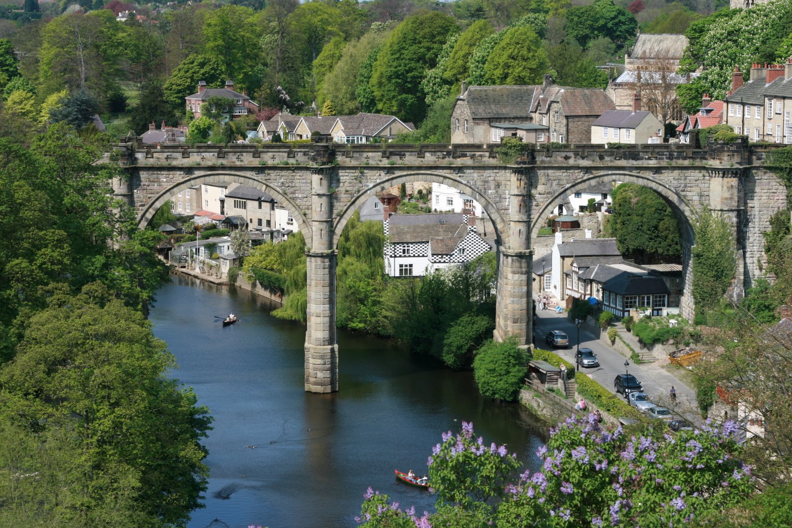
Places of interest
Italicised locations lie outside the current North Yorkshire shire county.
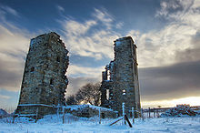 An ancient derelict hunting lodge in Dob Park, North Yorkshire.
- Ampleforth College
- Beningbrough Hall
- Bolton Abbey
- Bolton Castle
- Brimham Rocks
- Byland Abbey - English Heritage (EH)
- Castle Howard and the Howardian Hills
- Catterick Garrison
- Cleveland Hills
- Drax
- Duncombe Park - stately home
- Embsay & Bolton Abbey Steam Railway
- Eston Nab
- Falconry
- Flamingo Land Theme Park and Zoo
- Fountains Abbey
- Gisborough Priory
- Helmsley Castle - EH
- Ingleborough Cave - show cave
- Kirkham Priory
- Lightwater Valley
- Malham Cove
- Middleham Castle
- Mount Grace Priory - EH
- North Yorkshire Moors Railway
- Ormesby Hall - Palladian Mansion
- Richmond Castle
- Rievaulx Abbey - EH
- Ripley Castle - Stately home and historic village
- Ripon Cathedral
- Selby Abbey
- Scarborough Castle - EH
- Shandy Hall - stately home
- Skipton Castle
- Stanwick Iron Age Fortifications - EH
- Studley Royal Park
- Stump Cross Caverns - show cave
- Thornborough Henges
- Wharram Percy
- Whitby Abbey
- York Minster
- Yorkshire Air Museum
News and media
The County is served by BBC North East and Cumbria, and for more southerly parts of the county BBC Yorkshire. Yorkshire Television and Tyne Tees Television are also received in most areas of the County. BBC Tees is broadcast to northern parts of the county, whist BBC Radio York is broadcast more widely. BBC Radio Leeds is broadcast to southern parts of the county.
Transport
The main north-south road through the county is the A1/A1(M) which has gradually been upgraded to motorway status since the early 1990s. The only other motorways within the county are the short A66(M) near Darlington and a small stretch of the M62 motorway close to Eggborough.[3] The other nationally maintained trunk routes are the A168/A19, A64, the A66 and A174.
The East Coast Main Line (ECML) bisects the county stopping at Northallerton, Thirsk and York. Passenger services on the ECML within the county are operated by East Coast, First TransPennine Express and Grand Central. First TransPennine Express run services on the York to Scarborough Line and the Northallerton–Eaglescliffe Line (for Middlesbrough) that both branch off the ECML.
Northern Rail operate the remaining lines in the county including commuter services on the Harrogate Line, Airedale Line and York & Selby Lines, of which the former two are covered by the Metro ticketing area. Remaining branch lines operated by Northern include the Yorkshire Coast Line from Scarborough to Hull, the Hull to York Line via Selby, the Tees Valley Line from Darlington to Saltburn and the Esk Valley Line from Middlesbrough to Whitby. Last but certainly not least, the Settle-Carlisle Line runs through the west of the county with services again operated by Northern.
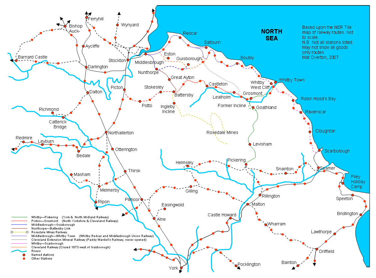
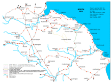 Current and former railway routes in eastern North Yorkshire
The county suffered badly under the Beeching cuts of the 1960s which saw places like Richmond, Ripon, Tadcaster, Helmsley, Pickering and the Wensleydale communities lose their passenger services. Notable lines closed were the Scarborough and Whitby Railway, Malton and Driffield Railway and the secondary main line between Northallerton and Harrogate via Ripon.
Heritage railways within North Yorkshire include the North Yorkshire Moors Railway between Pickering and Grosmont, which opened in 1973, the Derwent Valley Light Railway near York, and the Embsay and Bolton Abbey Steam Railway. The Wensleydale Railway, which started operating in 2003, runs services between Leeming Bar and Redmire along a former freight only line. The medium term aim to operate into Northallerton station on the ECML once agreement can be reached with Network Rail, whilst the longer term aim to re-instate the full line west via Hawes to Garsdale on the Settle-Carlisle line.
York railway station is the largest station in the county with 11 platforms and is a major tourist attraction in its own right. The station is immediately adjacent to the world famous National Railway Museum.
As well as long distance coach services operated by National Express and Megabus local bus service operators include Arriva, Harrogate & District, Scarborough & District (East Yorkshire Motor Services), Yorkshire Coastliner, First and the local Dales & District.
There are no major airports in the county itself but nearby airports include Durham Tees Valley, Newcastle, Robin Hood Doncaster Sheffield and Leeds Bradford.
Sports
North Yorkshire is home to several football clubs, the most successful of which is Middlesbrough FC who play in the Coca-Cola Championship; others include York City FC who have played in the Football League but today play in the Conference National. Whitby Town FC have reached the FA cup first round seven times, and have played the likes of Hull City, Wigan and Plymouth Argyle, they currently play in the Evo-Stik Premier league.
No notable rugby union teams hail from the county but York City Knights are a rugby league team and play in the Rugby League Championship.
North Yorkshire is home to many racecourses; these include Catterick Bridge, Redcar, Ripon and Thirsk. It also has one motor racing circuit, Croft Circuit; the circuit holds meetings of the British Touring Car Championship, British Superbike and Pickup Truck Racing race series.
Yorkshire County Cricket Club, play a number of fixtures at North Marine Road, Scarborough.
The ball game Rock-It-Ball was developed in the county.
See also
References
- ^ "North Yorkshire County Council : Contact us". www.northyorks.gov.uk. http://www.northyorks.gov.uk/index.aspx?articleid=42. Retrieved 2009-05-16.
- ^ Arnold-Baker, C., Local Government Act 1972, (1973)
- ^ a b "Transport map of shire county divided into districts" (PDF). North Yorkshire County Council. http://www.northyorks.gov.uk/CHttpHandler.ashx?id=514&p=0. Retrieved 2008-10-10.
- ^ "New council for North Yorkshire". North Yorkshire County Council. http://www.northyorks.gov.uk/public/site/NYCC/menuitem.72980bf1db3dfb9fd7428f1040008a0c/?vgnextoid=cfa68f0788110110VgnVCM100000420f1cacRCRD.[dead link]
- ^ "Proposals for future unitary structures: Stakeholder consultation" (PDF). Communities and Local Government. http://www.communities.gov.uk/documents/localgovernment/pdf/322770.pdf. Retrieved 2008-10-10.
- ^ "Decision letter: North Yorkshire County Council" (PDF). Communities and Local Government. http://www.communities.gov.uk/pub/59/DecisionletterNorthYorkshireCountyCouncil_id1512059.pdf.[dead link]
- ^ North East Assembly - List of local authorities and members
- ^ http://bubl.ac.uk/org/tacit/marilyns/chapter6.htm
- ^ OPSI - The North Yorkshire (District of York) (Structural and Boundary Changes) Order 1995
- ^ "North Yorkshire County Council Constitution". North Yorkshire County Council. http://www.northyorks.gov.uk/CHttpHandler.ashx?id=1990&p=0. Retrieved 10 May 2010.
- ^ http://www.northyorks.gov.uk/index.aspx?articleid=2874
- ^ http://www.northyorks.gov.uk/CHttpHandler.ashx?id=12525&p=0
- ^ "Regional Gross Value Added" (PDF). Office for National Statistics. 2005-12-21. pp. 240–253. http://www.statistics.gov.uk/downloads/theme_economy/RegionalGVA.pdf. Retrieved 2008-10-06.
- ^ Components may not sum to totals due to rounding
- ^ includes hunting and forestry
- ^ includes energy and construction
- ^ includes financial intermediation services indirectly measured
- ^ "Regional mapped climate averages". The Met Office. http://www.metoffice.gov.uk/climate/uk/averages/regmapavge.html#. Retrieved 27 September 2010.
- ^ "UK mapped climate averages". The Met Office. http://www.metoffice.gov.uk/climate/uk/averages/ukmapavge.html. Retrieved 27 September 2010.
- ^ "Temperature of -19C is new Yorkshire record". BBC News Online (BBC). 3 December 2010. http://www.bbc.co.uk/news/uk-england-york-north-yorkshire-11908065. Retrieved 4 December 2010.
External links
- North Yorkshire Guide Guide from NorthYorks.com
- BBC North Yorkshire North Yorkshire features, videos and pictures from the BBC
- Yorkshire Dales Rivers Trust
- Discover North Yorkshire North Yorkshire Tourist Information
- North Yorkshire at the Open Directory Project
Ceremonial county of North Yorkshire Unitary authorities Boroughs or districts Major settlements - Bedale
- Bentham
- Boroughbridge
- Catterick Garrison
- Easingwold
- Eston
- Filey
- Grassington
- Guisborough
- Harrogate
- Hawes
- Haxby
- Helmsley
- Ingleby Barwick
- Kirkbymoorside
- Knaresborough
- Leyburn
- Loftus
- Malton
- Masham
- Middleham
- Middlesbrough
- Northallerton
- Norton-on-Derwent
- Pateley Bridge
- Pickering
- Redcar
- Richmond
- Ripon
- Saltburn
- Scarborough
- Selby
- Settle
- Sherburn-in-Elmet
- Skelton-in-Cleveland
- Skipton
- South Bank
- Stokesley
- Tadcaster
- Thirsk
- Thornaby-on-Tees
- Whitby
- Yarm
- York
See also: List of civil parishes in North Yorkshire
Rivers Topics - Parliamentary constituencies
- Grade I listed buildings
- Monastic houses
- Museums
- Windmills
 Yorkshire
Ceremonial counties East Riding of Yorkshire • North Yorkshire • South Yorkshire • West Yorkshire
Historic divisions Geography History History • Brigantia • Parisiorum • Britannia • Elmet • Ebrauc • Deira • Northumbria • Jórvík • Wars of the Roses
Culture and heritage Culture • Dialect • On Ilkla Moor Baht 'at • People • Flags and symbols • White Rose • Yorkshire Day • God's Own County/Country
 Districts of Yorkshire and the Humber
Lincolnshire 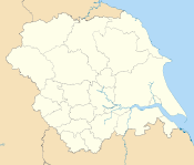
North Yorkshire Craven • Hambleton • Harrogate • Richmondshire • Ryedale • Scarborough • Selby • York
South Yorkshire West Yorkshire Bradford • Calderdale • Kirklees • Leeds • Wakefield
East Riding of Yorkshire Categories:- North Yorkshire
- Counties of England established in 1974
- Non-metropolitan counties


Wikimedia Foundation. 2010.