- Cleveland Hills
-
The Cleveland Hills Protected area 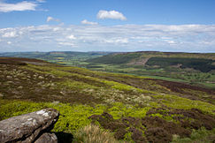 The Cleveland Hills from Urra Moor
Country England Ceremonial County North Yorkshire Coordinates 54°40′N 1°20′W / 54.667°N 1.333°W Highest point Urra Moor - elevation 454 m (1,490 ft) IUCN category V - Protected Landscape/Seascape 
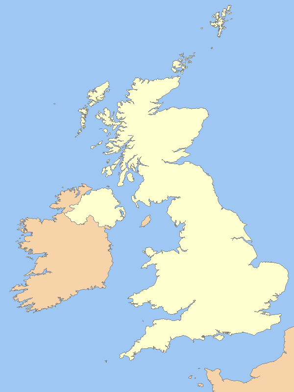
 Location of the Cleveland Hills in the UK
Website: http://www.northyorkmoors.org.uk/cleveland-hills/ The Cleveland Hills are a range of hills on the north-west edge of the North York Moors in North Yorkshire, England, overlooking Cleveland and Teesside. They lie entirely within the boundaries of the North York Moors National Park. Part of the 110-mile (177 km) long Cleveland Way National Trail runs along the hills, which is a part of Wainwright's Coast to Coast Walk. The hills, which rise abruptly from the flat Tees Valley to the north, include distinctive landmarks such as the cone-shaped peak of Roseberry Topping near the village of Great Ayton—childhood home of Captain Cook.[1]
Bilsdale West Moor, situated in the Cleveland Hills, is home to the Bilsdale transmitting station providing 40–50 miles coverage of UHF transmissions for digital TV and radio in the north-east.[2]
Contents
History
Formation
Geological studies of the Cleveland Hills plateau date the rocks back to the Middle Jurassic age, making the range approximately 161–176 million years old,[3] although the North York Moors are formed on rocks from the Lower Jurassic age resulting in shale erosion along the north and west faces of the hills. Roseberry Topping is an outlier which was formed as a result of erosion, separating it from the Cleveland Hills formation, making it a unique natural hill.[4]
Early man
There are a number of tumuli and stone circles[5] scattered over the Cleveland Hills and North York Moors, dating back to the Bronze Age, as well as many cairns that are of varied ages, some of which are relatively modern. Hundreds of flint arrowheads have been discovered during excavations in the hills and dated to the Mesolithic and Neolithic periods, indication of an active population in prehistoric times across the region.[6]
Stone circles in the Cleveland Hills
- Commondale
- Tripsdale Bride Stones
- Thimbleby Nine Stones
Mining and industry
In 1850 ironstone was discovered in the Eston Hills, outliers of the Cleveland Hills, leading to mining on a large scale and the rapid growth of nearby Middlesbrough.[7][8] By the 1870s industry would be producing steel in vast amounts, and mining for coal, alum, jet, cement stone concretions, shale and potash from the hills, as well as employing sandstone and limestone quarries to gather raw materials. Many of the mines and quarries are still evident today.
The hills
Hill Grid Reference Height to summit metres feet Urra Moor (Round Hill) NZ594015 454 1,490 Cringle Moor NZ537029 432 1,417 Carlton Bank NZ519026 408 1,339 Cold Moor NZ551035 402 1,319 Hasty Bank NZ565036 398 1,306 Tidy Brown Hill NZ603052 396 1,299 Bilsdale West Moor SE553966 395 1,296 Warren Moor NZ616075 335 1,099 Gisborough Moor NZ643123 328 1,076 Easby Moor NZ590101 324 1,063 Park Nab NZ614084 324 1,063 Roseberry Topping NZ579126 320 1,050 Live Moor NZ505013 315 1,033 Highcliff Nab NZ610138 310 1,017 Codhill Heights NZ614127 296 971 Eston Nab NZ561800 242 794 Towns and villages in the Cleveland Hills
There are numerous towns and villages on, or in the vicinity of, the Cleveland Hills including the following:
- Carlton-in-Cleveland
- Easby
- Eston
- Filey
- Great Ayton
- Great Broughton
- Guisborough
- Helmsley
- Kildale
- Newton under Roseberry
- Osmotherley
- Slapewath
- Staithes
- Stokesley
- Swainby
Interesting places to see
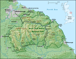 Map of the North York Moors area
- Captain Cook Monument, Easby Moor
- Captain Cook Schoolroom Museum, Great Ayton
- Roseberry Topping
- Wainstones, Hasty Bank[9]
References
- ^ "Captain James Cook - History". http://www.captaincook.org.uk/history.php. Retrieved 17 May 2011.
- ^ "TheBigTower Bilsdale Transmitter". http://en.wikipedia.org/w/index.php?title=Cleveland_Hills&action=edit. Retrieved 10 May 2011.
- ^ "Natural England: 25 North Yorkshire Moors and Cleveland Hills". http://www.naturalengland.org.uk/ourwork/landscape/englands/character/areas/north_yorkshire_moors_and_cleveland_hills.aspx. Retrieved 6 May 2011.
- ^ "Geology - Cleveland Hills - North York Moors National Park". http://www.northyorkmoors.org.uk/cleveland-hills/. Retrieved 6 May 2011.
- ^ "The Prehistoric Sites of Great Britain". http://www.stone-circles.org.uk/stone/index.htm. Retrieved 7 May 2011.
- ^ "Kirkletham Museum - First People Overview". http://www.redcar-cleveland.gov.uk/kirkleatham/FirstPeopleOverview.pdf. Retrieved 7 May 2011.
- ^ "Tees Archaeology". http://www.teesarchaeology.com/projects/eston_hills/index.html. Retrieved 6 May 2011.
- ^ "Middlesbrough and surrounds". http://www.englandsnortheast.co.uk/Middlesbrough.html. Retrieved 6 May 2011.
- ^ "The Wainstones". http://www.stone-circles.org.uk/stone/wainstones.htm. Retrieved 6 May 2011.
External links
Categories:- Geography of North Yorkshire
- Mountains and hills of Yorkshire
- Redcar and Cleveland


Wikimedia Foundation. 2010.