- River Esk, North Yorkshire
Infobox River | river_name = River Esk
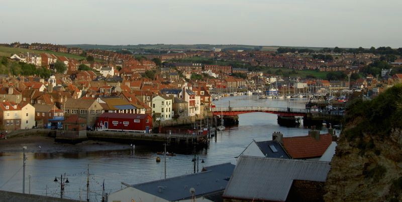
caption = The River Esk near its mouth at Whitby
origin =Westerdale Moor
mouth =Whitby
basin_countries =England
length = 45 km
elevation =
discharge =
watershed =The River Esk is a
river inNorth Yorkshire ,England that empties into theNorth Sea atWhitby after a course of around Convert|28|mi|km|lk=off through the valley of Eskdale, named after the river itself.Overview
Due to its rural nature, the river is clean and healthy, supporting a wealth of wildlife. Samon spawn right up through Eskdale, and a number of "leaps" are provided to enable them to travel through weirs on the course. There are clearly visible examples at
Ruswarp , where the tidal stretch through to Whitby begins and atSleights . Around Whitby the Esk has a large population ofSea Trout , and the river is noted for freshwater pearl mussels, although these are threatened with extiction due to buildups ofsilt in the river. [ cite web|url=http://www.bbc.co.uk/northyorkshire/content/articles/2007/11/27/esk_mussels_feature.shtml |title=Nurturing new life - Wonders of the Esk mussel |accessdate=2008-05-17|date=2007-11-28 |publisher=BBC ] . The Esk is also the only major river inYorkshire to drain directly into theNorth Sea [ cite web|url=http://www.ecn.ac.uk/sites/esk.html |title=ECN Freshwater Sites - River Esk |accessdate=2008-05-17|publisher=Environmental Change Network ]The river rises at the Esklets on
Westerdale Moor in theNorth York Moors , flowing through Westerdale before merging with a large number of becks from the surrounding hills, including Tower, Baysdale, Sleddale, Danby, Great Fryup, Stonegate, Glaisdale and Murk becks. Running east through the valley known as Eskdale it leaves the moors via the villages of Sleights and Ruswarp, reaching the North Sea three miles later by bisecting the resort of Whitby.Part way down the river at Danby bridge, there is a ford in which vehicles can get trapped. [ cite web|url=http://www.waymarking.com/waymarks/WM3G5Y |title=The river Esk ford at Danby Bridge N.Yorkshire Moors. |accessdate=2008-04-30 |last=fellsmanhiker |date=2008 |publisher=Groundspeak Inc. ]
Between the junction of Fryupdale and
Lealholm the river passes through a narrow, steep sided and wooded valley known as Crunkly Ghyll. Here the river drops Convert|100|ft|m|lk=on from the valley above to reach the village. Crunkly Ghyll was formed during the last great ice age as a huge wall of ice moved across the landscape carving out what is now the Esk Valley as far as Lealholm. At its head it formed a massive dam blocking the flow of water from above and creating a lake running back up the valley to Commondale. As the ice melted, the river forced its way out carving the ravine we see today. In Victorian times, the Ghyll was home to a large rockery garden, open to the public, but long since washed away by flooding of the river.The small villages along the river were at one time of great industrial importance to the north east, with
coal mined in the valleys, andiron ore dug from quarries on the surrounding moors. Today, all that remains are the deserted mine shafts, thoughpotash is mined, nearBoulby , with tunnels running six miles beneath the sea, some of the deepest inEurope .ettlements
"from source"
*
Westerdale
*Castleton
*Ainthorpe
*Danby
*Lealholm
*Glaisdale
*Egton Bridge
*Grosmont
*Sleights
*Aislaby
*Briggswath
*Ruswarp
*Whitby (flows into the North Sea)
The
Esk Valley Walk runs along part of the length of the river.See also
References
Wikimedia Foundation. 2010.