- Malton, North Yorkshire
-
Coordinates: 54°08′20″N 0°47′31″W / 54.139°N 0.792°W
Malton 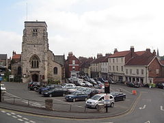
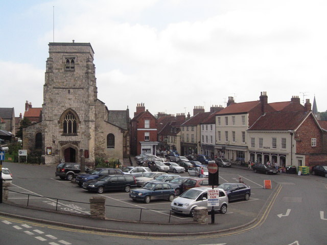
Malton Market Place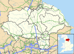
 Malton
Malton shown within North YorkshirePopulation 4,000 OS grid reference SE788722 - London 230.7 mi District Ryedale Shire county North Yorkshire Region Yorkshire and the Humber Country England Sovereign state United Kingdom Post town MALTON Postcode district YO17 Dialling code 01653 Police North Yorkshire Fire North Yorkshire Ambulance Yorkshire EU Parliament Yorkshire and the Humber UK Parliament Thirsk and Malton List of places: UK • England • Yorkshire Malton is a market town and civil parish in North Yorkshire, England. The town is the location of the offices of Ryedale District Council and has a population of around 4,000 people.
It is located to the north of the River Derwent which forms the historic boundary between the North and East Ridings of Yorkshire.
Facing Malton on the other side of the Derwent is Norton. Malton Bacon Factory, Malton bus station and Malton railway station are actually located in Norton-on-Derwent.
Malton is the local commercial centre. In the town centre there are lots of small traditional independent shops. The market place has recently become a meeting area with a number of coffee bars and cafés opening all day to complement the public houses.
Contents
History
Roman
The town stands on the site of a former Roman settlement, although no firm conclusion has been agreed upon as to which this settlement actually was. The uncertainty surrounds, in particular, the exact location of the Roman town of Derventio. Contradictory records describe Derventio as being either 7 or 17 miles east of York. The former is consistent with the site of a Roman settlement known to have existed in proximity to the current village of Stamford Bridge, in which case the settlement at Malton is more likely to have been Delgovicia. The latter places Derventio at Malton.
If there is still academic debate about the name, what is certain is that Roman Malton was, from the second half of the first century, a busy and a lively place. Consisting firstly of the important cavalry fort whose remains lie in Old Malton under the former pasture land known as Orchard Fields, right beside a disused railway cutting, it eventually extended to include an adjoining area of civil settlement or vicus on the north bank, immediately south of the fort and sited above the necessary river crossing or bridge(s) below. Right opposite, on the southern side of the modern river Derwent (whose name is immediately traceable back to that Derventio commonly suggested as most likely place name in Roman times) was an area of ‘grid iron’ street planning and metal workshops which we know from an inscription included a goldsmith’s shop managed for its owner by a young slave. These ‘planned’ Roman streets on the south bank therefore seem natural precursor to the more industrial atmosphere and activity which modern Norton still retains to this day, whilst Roman Malton across the river could boast at least one fine townhouse that was furnished with painted walls, mosaic floors, heated rooms and sculptural architectural decoration, examples of which can all be seen in the Malton Museum in the Old Town Hall.
Likewise, what we know of Roman horse-keeping activity seems to echo modern Malton’s continuing reputation as another Yorkshire town famous for racehorse breeding and training. Derventio itself was a strategically important cavalry fort, 17 miles from the Legionary fortress at York (Eboracum) and standing at the very hub of Roman road networks extending right across North and East Yorkshire. Its known garrison, the Ala Picentiana, was a regiment or cavalry ‘wing’ of some repute, one arguably traceable from its first being raised in Gaul (modern France) under Julius Caesar himself; to its later serving in the Balkans (under a man called Picens whom the regiment is believed to be named after) before eventual posting to Britain. Marcus Claudius Bassus was a known commander of the regiment whilst in Malton, but another man called Candidus and his own links with the Ala at Derventio receive permanent record in a beautifully-lettered fragmentary dedication stone set up by the unit commander outside the south-east gate of the fort, then eventually found in 1970 before going on display in the Old Town Hall today.
As well as York itself, their road network shows us what key strategic and social links there were for Malton to the only other important Roman town located within the territory of the local Celtic tribe, the Parisii; namely their tribal capital, Roman naval-base and major ferry-crossing sited at Brough-on-Humber (Petuaria). As the historical novelist Clive Ashman so vividly puts it in “MOSAIC – the Pavement that Walked” (Voreda Books) his fictionalised account of not only the true-life, 1948 theft of a Roman mosaic from Brough, but also the original fate of the Roman villa it came from (and of the Ala Picentiana itself): “As for the glorious Ala traceable back to Julius Caesar’s Gallic Wars, it is an inevitable truth that hundreds of years later there came one final day when its men rode jingling out of Derventio fort, never to be seen there again.”
Once the Ala had gone, it was replaced towards the end of the Romans’ 350-year occupation by an irregular unit sent up from Brough – the Numerus Supervenientum Petuarensium. This proved just a temporary measure in what became ever darker times. From 367 AD until the last Roman troops withdrew around 405 AD, Roman Malton was attacked and ruined several times – by the end it was not much better than an enclosure of fallen rubble they were vainly cutting their fresh defensive ditches around. What they made of it all we can only guess, but we do know that these people living amongst the ruins of Roman Malton were about to enter that long period known to us now as the Dark Ages.
Mediaeval Malton
In the 11th century, a wooden Norman castle was built in what is now castle Garden. This had been rebuilt in stone by Eustace de Vescy by the time Richard the Lionheart visited the castle in 1189. Other visitors included Edward II, in 1307 and Robert the Bruce in 1322. The great house subsequently became ruined.[1]
The castle site was inherited by Lord William Eure in 1544, when he was also made a baron.[note 1] In 1569, Ralph, 3rd Lord Eure built a new house on the castle site and in 1602, the house was rebuilt in much grander style. This was a spectacular property and it was described by the diarist and gunpowder plotter Sir Henry Slingsby as the rival of many other great houses, including that at Audley End.[1]
The house was subsequently demolished 1674 and the stones divided between two sisters, Mary and Margaret Eure. They had quarrelled over their inheritance and the demolition was the settlement ordered by Sheriff Henry Marwood. The Old Lodge Hotel is the remaining fragment of the original Jacobean "prodigy house" and its size hints at the grandeur of the complete structure.[1]
Parliamentary representation
In Mediaeval times, Malton was briefly a parliamentary borough in the 13th century, and again from 1640 to 1885; the borough was sometimes referred to as New Malton. It was represented by two Members of Parliament until 1868, among them the political philosopher Edmund Burke, and by one member from 1868 to 1885.
Recent history
In 1982 Malton was the scene of an 800-man police siege when gunman Barry Prudom hid in the village having murdered three people.[2] Prudom briefly kidnapped three villagers, eventually shooting himself when his hideout was found by police.[3]
Today
Attractions in modern Malton include the signposted remains of the Roman fort at 'Orchard Fields', the Malton Museum and Malton Priory a Gilbertine priory. Eden Camp, a military themed museum, is located just outside the town.
Both towns are known in connection with Charles Dickens who made regular visits to the area to see his friend Charles Smithson, he also wrote the famous novel A Christmas Carol while staying in Malton. There have been recent revivals of Dickens-related festivals.
Malton and the neighbouring village of Old Malton provide the settings for the collection of stories told in the book, "All is Bright - A Yorkshire Lad's Christmas" by Dave Preston.
In 2007 WSP Group and Atisreal for Ryedale District Council and Yorkshire Forward revealed new regeneration plans for Malton.
These plans include;
- The Mount Hotel - to be modified and renovated into high quality Residential Apartments
- York House - to be changed for community use/offices/Tourist Information/museum?
- Livestock Market - area to be relocated to Pasture Lane. Once completed the old livestock market area will be in mixed use for retail, residential and parking.
- The Market Place - Improved public realm and new pedestrian priority areas
- Wheelgate - Improved pedestrian / shopping environment
- Greengate - New delivery route for eastern section of Wheelgate
- East Mount - New residential apartments and housing
- Wentworth Street Car Park - Mixed use development (supermarket / residential / parking)[4]
However, major property owners, the Fitzwilliam Estate, considers that taking a more traditionalist approach is a more appropriate option for the town.[5]
Malton holds a market every Saturday, as well as a farmers' market once every month. The town has a war memorial and several historical churches (Norton-on-Derwent also holds large church buildings). The town is served by Malton railway station.
Malton is a popular destination for people visiting North Yorkshire because of the nearby village of Kirby Misperton, the location of the largest amusement park in the region, Flamingo Land Theme Park and Zoo.
Malton is the middle-ground between York, Pickering (access to the North Yorkshire Moors and also a terminus of the North Yorkshire Moors Railway), Scarborough, Filey and Whitby.
Fitzwilliam (Malton) Estate
The Fitzwilliam (Malton) Estate owns and manages commercial, residential and agricultural property in and around the town of Malton. The Estate, whilst it has a commercial property business to manage, has a strong community focus with the aim of improving the town both socially and economically for the benefit of its tenants and the wider community.[6]
Local community organisations are supported by charitable donations through the Earl Fitzwilliam Charitable Trust.
We Love Malton
The ‘We Love Malton’ campaign was launched in March 2009. It aims to reinvigorate the town of Malton and raise its appeal with both residents and tourists. We Love Malton host events throughout the year, the flagship of these being the Malton Food Lovers Festival. This annual event entices over 5000 visitors to the North Yorkshire town and features Michelin-starred and award-winning chefs, as well as around 90 food producer stalls.[7] The next Food Lovers Festival will take place on 21 and 22 May 2011.
Education
There are two secondary schools in Malton and Norton, Malton School, founded in 1547, and Norton College, a DCSF “High Performing” Specialist School and an Ofsted designated “outstanding” school. The town is served by St Mary's RC Primary School, Norton Community Primary School and Malton Community Primary School. Woodleigh School the nearest independent school, drawing much of its intake from Malton and Norton.
Climate
As with the rest of the British Isles and Yorkshire, Malton possesses a maritime climate with cool summers and mild winters. The nearest Met Office weather station for which records are available is High Mowthorpe, about 6 miles east of the town centre. Due to its lower elevation, the town centre is likely to be marginally warmer than High Mowthorpe throughout the year.
Climate data for High Mowthorpe 175m asl, 1971-2000, Extremes 1960- Month Jan Feb Mar Apr May Jun Jul Aug Sep Oct Nov Dec Year Record high °C (°F) 13.3
(55.9)15.0
(59.0)20.6
(69.1)21.7
(71.1)25.0
(77.0)28.4
(83.1)28.5
(83.3)33.2
(91.8)26.4
(79.5)21.7
(71.1)16.2
(61.2)14.5
(58.1)33.2
(91.8)Average high °C (°F) 5.1
(41.2)5.4
(41.7)7.8
(46.0)10.0
(50.0)13.4
(56.1)16.4
(61.5)19.2
(66.6)19.4
(66.9)16.2
(61.2)12.1
(53.8)8.0
(46.4)6.0
(42.8)11.6 Average low °C (°F) 0.3
(32.5)0.5
(32.9)1.8
(35.2)3.1
(37.6)5.6
(42.1)8.2
(46.8)10.5
(50.9)10.6
(51.1)9.0
(48.2)6.4
(43.5)3.1
(37.6)1.3
(34.3)5.1 Record low °C (°F) −10.2
(13.6)−10.9
(12.4)−8.9
(16.0)−5.7
(21.7)−2.3
(27.9)−0.6
(30.9)3.9
(39.0)3.9
(39.0)0.6
(33.1)−2.8
(27.0)−7.5
(18.5)−14.6
(5.7)−14.6
(5.7)Precipitation mm (inches) 68.7
(2.705)48.1
(1.894)59.2
(2.331)54.8
(2.157)52.8
(2.079)62.1
(2.445)53.4
(2.102)56.9
(2.24)61.4
(2.417)68.2
(2.685)68.0
(2.677)75.8
(2.984)729.4
(28.717)Sunshine hours 48.4 66.1 99.8 134.4 186.9 173.1 179.5 173.9 130.8 100.8 62.7 41.5 1,397.9 Source no. 1: Met Office[8] Source no. 2: Royal Netherlands Meteorological Institute[9] Transport
By road
Malton is on the A64, which runs from Leeds and York to Scarborough, at the junction with the A169 to Pickering and Whitby. A by-pass was built in 1979, but the narrow streets through the town centre are still very congested.
By train
Malton railway station is on the TransPennine Express route, with fast trains every hour running from Scarborough to York, Leeds, Manchester and Liverpool.
There are plans to re-open the rail link between Malton and Pickering, which would create a new service from Malton to Whitby.
By bus
Malton is home to Coastliner (website), a division of the TransDev bus group. Buses run from Leeds and York through Malton to Pickering/Whitby, Scarborough, and Bridlington. There are also regular buses to Castle Howard and Hovingham, and a number of other local bus routes.
See also
Notes
- ^ The Eure family had a long and interesting connection with the area – William's son Ralph, born in 1510, defended Scarborough Castle against the Pilgrimage of Grace in 1536 and became Warden of the East Marches . He was also involved in the burning of Edinburgh in 1544. The exploits of this bloody warrior are commemorated in Sir Walter Scott's poem entitled 'Lord Eurie'.
References
- ^ a b c "Malton Castle Garden". Derwent Riverside Project. 2008. http://www.maltoncastlegarden.org.uk/History.html. Retrieved 1 October 2010.
- ^ "800 Bobbies hunt triple killer" Tri City Herald 30 June 1982 Retrieved 24 March 2010
- ^ "Killer on run leaves trail" Yorkshire Post 16 June 2004 Retrieved 24 March 2010
- ^ "A strategy for Malton town centre". Ryedale District Council. http://www.ryedale.co.uk/ryedale/malton/malton%20town%20centre%20strategy%20issued%20version.pdf. Retrieved 29 January 2010.
- ^ "Fitzwilliam Malton Estate". maltonestate.co.uk. http://www.maltonestate.co.uk/html/story4.htm. Retrieved 2010-01-29.
- ^ "Fitzwilliam Malton Estate". maltonestate.co.uk. http://www.maltonestate.co.uk/. Retrieved 2010-11-22.
- ^ "We Love Malton". welovemalton.co.uk. http://www.welovemalton.co.uk. Retrieved 2010-11-22.
- ^ "High Mowthorpe Averages". UKMO. http://www.metoffice.gov.uk/climate/uk/averages/19712000/sites/high_mowthorpe.html. Retrieved 08 Nov 2011.
- ^ "High Mowthorpe extremes". KNMI. http://eca.knmi.nl/utils/mapserver/anomaly.php?indexcat=**&indexid=TNn&year=1995&seasonid=18&create_image=true&minx=-1111428.5714287&miny=-4687142.8571429&maxx=621904.76190476&maxy=-3387142.8571428&MapSize=560%2C420&imagewidth=560&imageheight=420&mainmap.x=345&mainmap.y=244&CMD=QUERY_POINT&CMD=QUERY_POINT#bottom. Retrieved 08 Nov 2011.
- Derventio - (Malton) Roman Fort and Civilian Settlement L. Peter Wenham (Cameo Books 1974)
- The Romans In East Yorkshire John H. Rumsby, English Life Publications 1980
- Mosaic – the Pavement that Walked Clive Ashman (Voreda Books, London, 2008: ISBN 978-0-9556398-0-7)
External links
- Malton on Ryedale.co.uk
- Malton School
- Norton College
- Langton Primary School, Malton
- Malton Mercury Newspaper
- Malton Museum
Ceremonial county of North Yorkshire Unitary authorities Boroughs or districts Major settlements Bedale • Bentham • Boroughbridge • Catterick Garrison • Easingwold • Eston • Filey • Grassington • Guisborough • Harrogate • Hawes • Haxby • Helmsley • Ingleby Barwick • Kirkbymoorside • Knaresborough • Leyburn • Loftus • Malton • Masham • Middleham • Middlesbrough • Northallerton • Norton-on-Derwent • Pateley Bridge • Pickering • Redcar • Richmond • Ripon • Saltburn • Scarborough • Selby • Settle • Sherburn-in-Elmet • Skelton-in-Cleveland • Skipton • South Bank • Stokesley • Tadcaster • Thirsk • Thornaby-on-Tees • Whitby • Yarm • York
See also: List of civil parishes in North YorkshireRivers Topics Parliamentary constituencies • Grade I listed buildings • Monastic houses • Museums • WindmillsCategories:- Market towns in North Yorkshire
- Civil parishes in North Yorkshire
- People from Malton, North Yorkshire
- Towns in North Yorkshire

Wikimedia Foundation. 2010.