River Foss

River Foss

Infobox River | river_name = River Foss
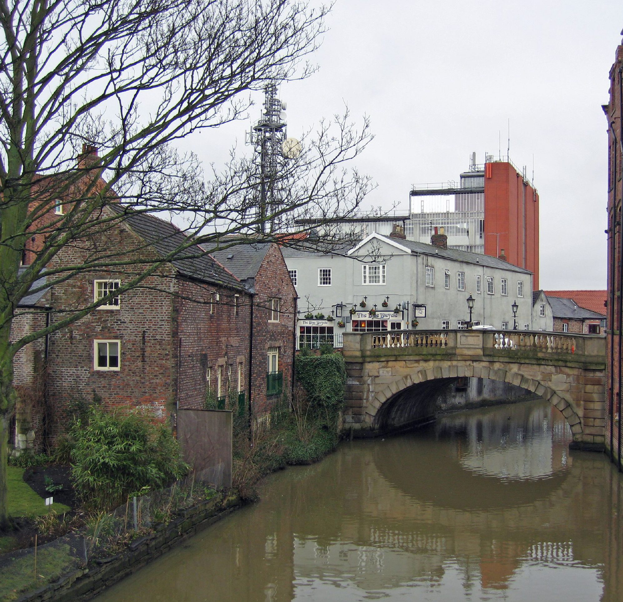


caption = The River Foss at York
origin = Near Oulston Reservoir, Yearsley
mouth = River Ouse, York
basin_countries = England
length =
elevation = 160 m (525 ft)
discharge =
watershed =
The River Foss is an improved river in North Yorkshire, England, and a tributary of the River Ouse. It rises at Oulston reservoir at Yearsley and runs south through the Vale of York to York itself, which stands at the confluence of the Ouse and the Foss.

William the Conqueror dammed the River Foss in 1069 just south of York Castle close to its confluence with the Ouse in order to create a moat around the castle complex. The damming also caused the river to flood further upstream in what is now the Hungate and Layerthorpe areas, forming a large lake that would become known as the "King's Pool" (or "King's Fishpool"). The King's Pool became an integral part of the city's inner defences during the Middle Ages (which explains the absence of defensive wall in the area today) and became well-known for its abundance of fish. By the 17th Century, however, the King's Pool and the Foss as a whole were in a state of decline. Silt from upriver had been collecting in the lake and there was not enough water coming down to move it on. This continued over the centuries to a point that the lake had become too shallow to remain viable as a defence of the city. Indeed, by 1644 the lake was shallow enough for Parliamentarian forces under Sir Thomas Fairfax to consider crossing it on foot as a way of breaking the Siege of York during the English Civil War. A century later, the waters were so low that marshy islands had begun to appear, giving the area its modern name of Foss Islands, and the townspeople had taken to throwing animal waste and other rubbish into the water. During the summer months the river smelled foul and was mostly dry and stagnant. The authorities knew that something had to be done.

Improvement works were promoted by Acts of Parliament in 1793 and 1801. In the works that followed what remained of the King's Pool finally disappeared and the newly-formed Foss Navigation Company canalised the river and sought to make it navigable as far as Sheriff Hutton. Today, it is only navigable for just over a mile from Monk Bridge to Blue Bridge, where it joins the Ouse.

The Foss Barrier is built across the river near its mouth. When closed, it prevents floodwater from the much larger Ouse flowing "up" the Foss and flooding those parts of York in its vicinity. Water flowing "down" the Foss can be pumped over the top of the barrier and into the Ouse.

Sources

*cite book | last = Evans | first = Antonia (ed)| title =The York Book | publisher =Blue Bridge | location =York|year = 2002 | id =ISBN 0-9542749-0-3


Wikimedia Foundation. 2010.

Игры ⚽ Поможем решить контрольную работу

Look at other dictionaries:

  • Foss — is a surname, and may refer to* Arthur Foss * Byron Foss * Charles Calveley Foss * Chris Foss, British illustrator and science fiction artist * Claire Foss * Craig Foss * Edward Foss, English lawyer and biographer * Eugene Foss * Frank H. Foss *… …   Wikipedia

  • Foss Islands Branch Line — The Foss Islands Branch Line was a former railway branch line in the city of York. The line, about mi to km|1.75 long, opened in 1880, connecting the York to Scarborough Line of the North Eastern Railway to a large freight depot in the Foss… …   Wikipedia

  • Foss River Falls — ( Falls River Falls , in Norwegian) is a convert|650|ft|m|adj=on drop on the Foss River in the Alpine Lakes Wilderness Area, King County, Washington. Its sources are at Delta Lake, and the convert|70|ft|m|sing=on wide (21 m) drop flows year round …   Wikipedia

  • Foss —    FOSS, late a quoad sacra parish, partly in the parish of Fortingal, but chiefly in that of Dull, county of Perth, 8 miles (N.) from Dull; containing 450 inhabitants, of whom 11 are in Fortingal. This district was separated for ecclesiastical… …   A Topographical dictionary of Scotland

  • Foss Dyke — The Foss Dyke, or Fossdyke, may be the oldest canal in England which is still in use. It was long thought to have been constructed by the Romans around 120 AD,Jane Cumberlidge, (1998), Inland Waterways of Great Britain , Imray Laurie Norie adn… …   Wikipedia

  • River Ouse, Yorkshire — Infobox River | river name = River Ouse caption = The River Ouse in York origin = Swale Nab, near Linton on Ouse mouth = River Humber at Ousefleet basin countries = United Kingdom (England) length = 55 miles elevation = 9 m (30 ft) discharge =… …   Wikipedia

  • River Tummel — The River Tummel is a river in Perthshire, Scotland. Discharging from Loch Rannoch, it flows east to a point near the Falls of Tummel, where it bends to the southeast, a direction which it maintains until it falls into the River Tay, just below… …   Wikipedia

  • River — (Roget s Thesaurus) >Water in motion. < N PARAG:River >N GRP: N 1 Sgm: N 1 running water running water GRP: N 2 Sgm: N 2 jet jet spirt spurt squirt spout spray splash rush gush …   English dictionary for students

  • Washita River — River, west and south central Oklahoma, U.S. It rises in northwestern Texas and flows east across the Oklahoma boundary, then southeast to south central Oklahoma, and south into the Red River. It is 626 mi (1,007 km) long. The Battle of the… …   Universalium

  • Trent, River — River, central England. It rises in Staffordshire and flows northeast 168 mi (270 km) to unite with the River Ouse west of Hull to form the River Humber. It is navigable by barge for over half its length. * * * ▪ river, England, United Kingdom… …   Universalium

Share the article and excerpts

Direct link
Do a right-click on the link above
and select “Copy Link”