- Middleham
-
Coordinates: 54°17′09″N 1°48′31″W / 54.2859°N 1.8087°W
Middleham 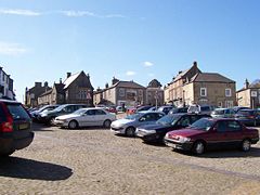
Middleham Marketplace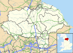
 Middleham
Middleham shown within North YorkshirePopulation 840 OS grid reference SE124878 District Richmondshire Shire county North Yorkshire Region Yorkshire and the Humber Country England Sovereign state United Kingdom Post town LEYBURN Postcode district DL8 Dialling code 01969 Police North Yorkshire Fire North Yorkshire Ambulance Yorkshire EU Parliament Yorkshire and the Humber UK Parliament Richmond List of places: UK • England • Yorkshire 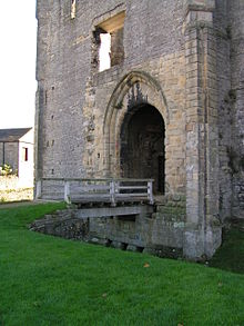 Gatehouse of the Castle
Middleham is a small market town and civil parish in the Richmondshire district of North Yorkshire, England. It lies in Wensleydale, in the Yorkshire Dales, on the north-facing side of the valley just above the junction of the River Ure and River Cover. There has been a settlement there since Roman Britain. It was recorded in the Domesday book as "Medelai".
Middleham is twinned with the northern French town of Agincourt.
Contents
History
The first known settlement at Middleham was during the Roman Era. The IXth Legion of the Roman Army conquered York in 69 AD and moved north quickly. A branch road of the Great North Road passed through Middleham to Bainbridge. Near Middleham, the Romans built a guard station to control traffic on the River Ure.[1]
 William's Hill is the remaining earthworks of the Motte-and-Bailey Castle Alan Rufus built.
Before the Norman Conquest the lands in this area were controlled by Gilpatrick. in 1069, the land in the area of Middleham was given to William the Conqueror's nephew, Alan Rufus. Rufus built a wooden motte-and-bailey castle above the town, whose earthworks are still visible today and called "William's Hill". Rufus also built the well known castle at Richmond.
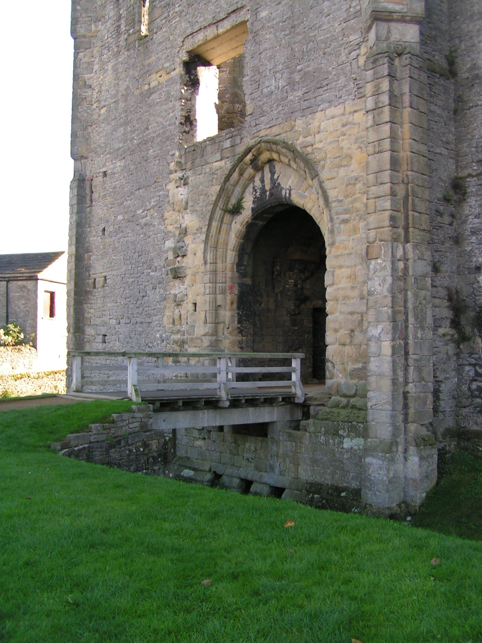
The present castle which dominates the town, Middleham Castle, was started in 1190. The Nevilles, Earls of Westmoreland, acquired it through marriage in the 13th century. It was called the "Windsor of the North". The castle was in the possession of Richard Neville, 16th Earl of Warwick when his young cousin Richard, Duke of Gloucester (the future Richard III ) came here to learn the skills of knighthood in 1462. During the Wars of the Roses, both Edward IV and Henry VI were held prisoner here. Richard, Duke of Gloucester became master of the castle in 1471 after Warwick died at the Battle of Barnet. Richard used the castle as his political base as he administered the North for his brother Edward IV. Richard married Warwick's daughter, Anne Neville, in 1472. Middleham Castle is where their son Edward was born (c. 1473) and were he died in April 1484. Richard III died in August 1485 in the Battle of Bosworth. He was the last reigning King of England to die in battle.[2]
At the time of King Richard III, Middleham was a bustling market town and important political centre[citation needed]. As early as 1389 the lord of Middleham Manor received a grant from the crown to hold a weekly market in the town and a yearly fair on the feast of St. Alkelda the Virgin.[3] The town itself is built around two markets, the larger, lower market is dominated by a large mediaeval cross which is now topped by a relatively modern iron cross in the celtic style. The upper, or swine market, centers around the remains of a 15th-century market cross and an oblong line of steps. At one end of the market cross is a worn effigy of an animal reclining and at the other may have had a moulded capital.
Most buildings in the old part of Middleham were built after 1600, though the old rectory of the church has some mediaeval elements incorporated into it.[4] In 1607 it is documented that Middleham was important enough to have a Royal Court, and all residents of the forest of Wensleydale fell under its jurisdiction.[5] From the ascension of Richard III until Charles I sold it to the City of London about 1628, Middleham and surrounding lands were part of the Crown's estates.[6] In 1661 the City of London sold Middleham Manor to Thomas Wood of Littleton, and it has remained in private hands until today.[7] In 1915 the yearly livestock market was still one of the most important in the North, though the weekly market had already fallen into disuse. Today the livestock market has moved to Leyburn.
Parish Church
 Church of Saints Mary and Alkelda
The Church of Saints Mary and Alkelda was founded in 1291 and today is mainly of 14th and 15th century architecture, though there are a few stones indicating the existence of a church on that site perhaps a century before that.[8] The only remaining Norman artifact is a section of zig-zag moulding that was once around a door or window, and today is high up above the north aisle. The church also boasts a 3 m high Perpendicular font cover and a copy of the Middleham Jewel. Just west of the church is St Alkelda's well, whose waters are reputed to restore strength to weak eyes. In 1478 King Edward IV gave permission for a leper hospital to be built on the east side of town in association with the church. Today, though the location is still known as Chapel Fields, it is given over to a horse training stables of the same name, and no traces of the hospital or chapel remain.[1]
Middleham today
Today the town is a modern centre of horse racing in the UK and is home to the Middleham Trainers' Association. The first racehorse trainer to train at Middleham was Isaac Cape in 1765. Today there are several racehorse trainers based here including Mark Johnston, and Patrick Haslam. Racing is the number one employer in the town. Tourism is the second biggest industry in the town. The castle is now a ruin, after having been dismantled in 1646. The keep, which was built by Robert Fitz Ralph in the 1170s survives to this day along the 13th century chapel and the 14th century gatehouse.
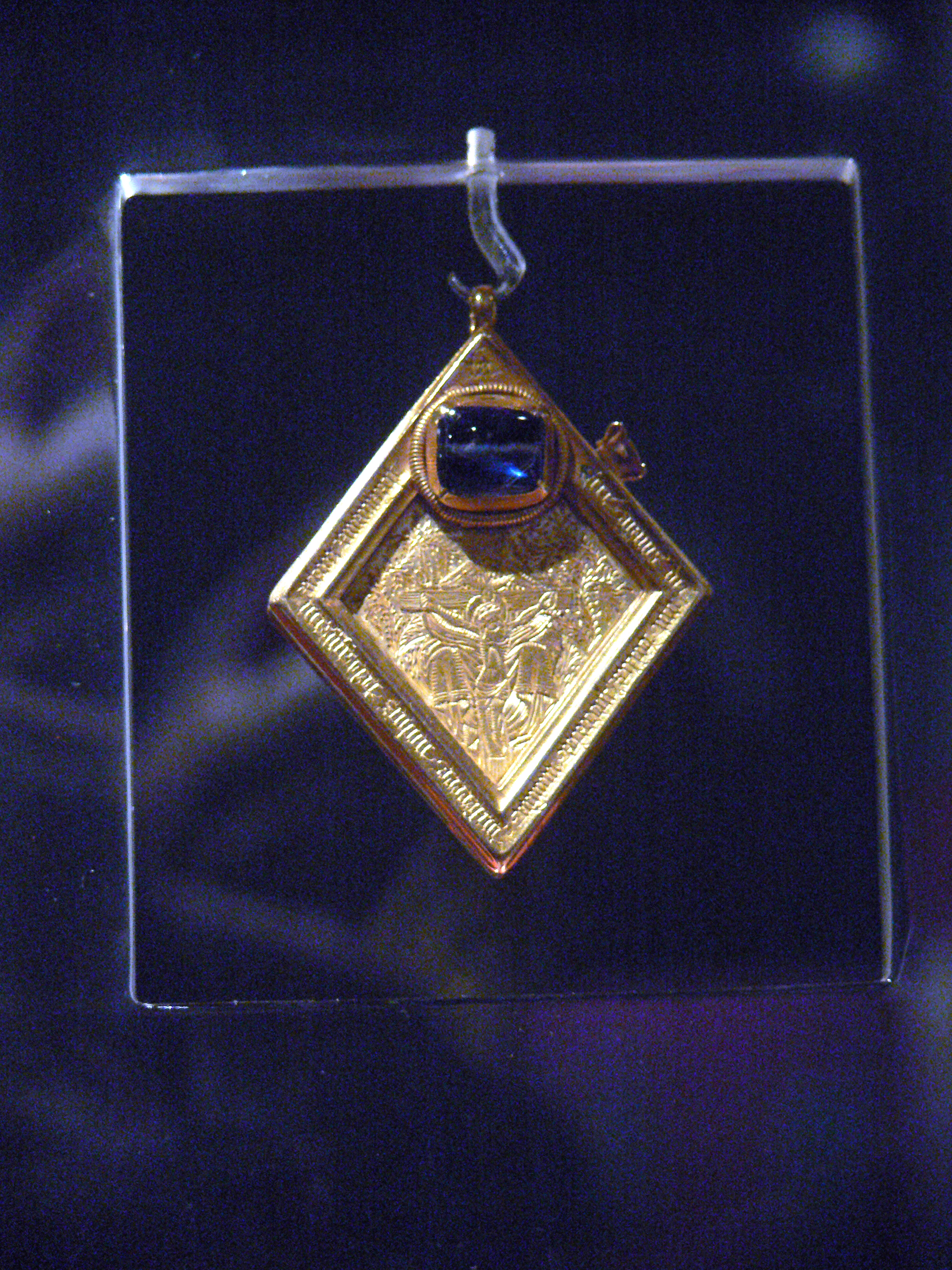
Middleham Jewel
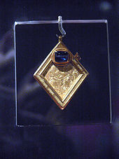 The front of the Middleham Jewel showing the Crucifixion of Jesus.
In 1985 the Middleham Jewel was found in the grounds of the castle by a man who was using a metal detector in the area. The Middleham Jewel is a mid-15th century 68 gram gold pendant with a 10 ct. blue sapphire stone. One side of the diamond shaped pendant is engraved with a representation of the Trinity and the other with a Latin inscription indicating that the pendant is a charm against epilepsy.[9] The sapphire may represent heaven.[10] It has been acquired by the Yorkshire Museum in York for £2.5 million.
Another find around the castle is a livery badge, for pinning to the chest or a hat, in gilded copper high relief, with Richard III's emblem of a white boar, very likely worn by one of his household when he was Duke of Gloucester.[11]
Natural history of the parish of Middleham
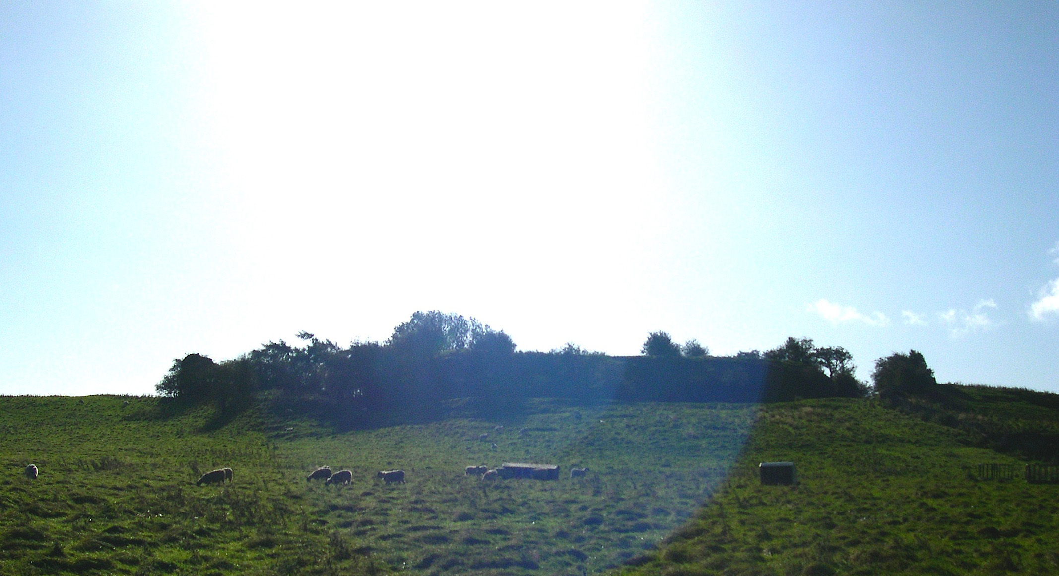
The town of Middleham lies between 400 and 500 feet (150 m) above ordinance datum, though the valley of the River Ure just below the town is only 325 feet (99 m) of elevation and the summit of the hill rising to the south-west of the town is 850 feet (260 m). The parish contains 2,155 acres (8.72 km2) of land, which is mostly permanent pasture- only about 150 acres (0.61 km2) are arable. The topsoil in this area is of mixed composition. The valley has modern alluvial terraces and gravel deposits, but the subsoil is mainly limestone, though it is intersected here and there by sandstone with plate. There is a known vein of lead in the northern part of the parish, and Braithwaite lead mine lies just outside the parish borders.[4]
References
- ^ a b http://home.cogeco.ca/~richardiii/pilgrimage.html
- ^ http://www.middlehamonline.com/Middleham%20Castle.htm
- ^ Chart. R. 11–13 Ric. II, m. 21; cf. Cal. Pat. 1436–41
- ^ a b A History of the County of York North Riding: Volume 1, William Page (ed.) 1914
- ^ Exch. Dep. Mich. 5 Jas. I, no. 8. The earliest lords claimed the forest of Wensleydale by inheritance (Pipe R. 4 John [Yorks.]; Abbrev. Plac. [Rec. Com.], 74; Coram Rege R. Mich. 12 Hen. III)
- ^ Pat. 4 Chas. I, pt. xxxiii, Roll B.; Cal. Com. for Comp. 2444; Exch. Dep. East. 13 Chas. II, no. 15.
- ^ N. and Q. Sept. 1884; Whitaker, Richmondshire
- ^ A History of the County of York North Riding: Volume 1, William Page (ed.) 1914
- ^ Middleham Jewel, The Art Fund
- ^ Cherry, John. The Holy Thorn Reliquary, p. 7, 2010, British Museum Press (British Museum objects in focus), ISBN 0714128201
- ^ Cherry, John (2003), in Marks, Richard and Williamson, Paul, eds., Gothic: Art for England 1400-1547, p. 204, no. 69, 2003, V&A Publications, London, ISBN 1851774017
External links
- Middleham Online
- Middleham Trainers' Association
- A Pilgrimmage to Middleham
- North Yorkshire Market Towns: Middleham
- The Key Centre
- The Forbidden Corner
Ceremonial county of North Yorkshire Yorkshire Portal Unitary authorities Boroughs or districts Major settlements Bedale • Bentham • Boroughbridge • Catterick Garrison • Easingwold • Eston • Filey • Grassington • Guisborough • Harrogate • Hawes • Haxby • Helmsley • Ingleby Barwick • Kirkbymoorside • Knaresborough • Leyburn • Loftus • Malton • Masham • Middleham • Middlesbrough • Northallerton • Norton-on-Derwent • Pateley Bridge • Pickering • Redcar • Richmond • Ripon • Saltburn • Scarborough • Selby • Settle • Sherburn-in-Elmet • Skelton-in-Cleveland • Skipton • South Bank • Stokesley • Tadcaster • Thirsk • Thornaby-on-Tees • Whitby • Yarm • York
See also: List of civil parishes in North YorkshireRivers Topics Parliamentary constituencies • Grade I listed buildings • Monastic houses • Museums • WindmillsCategories:- Market towns in North Yorkshire
- Civil parishes in North Yorkshire
- Wensleydale
- Richmondshire
- Towns in North Yorkshire


Wikimedia Foundation. 2010.