- Pennines
-
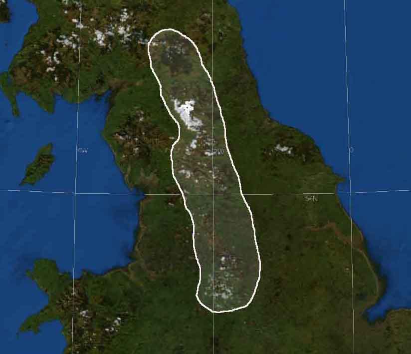
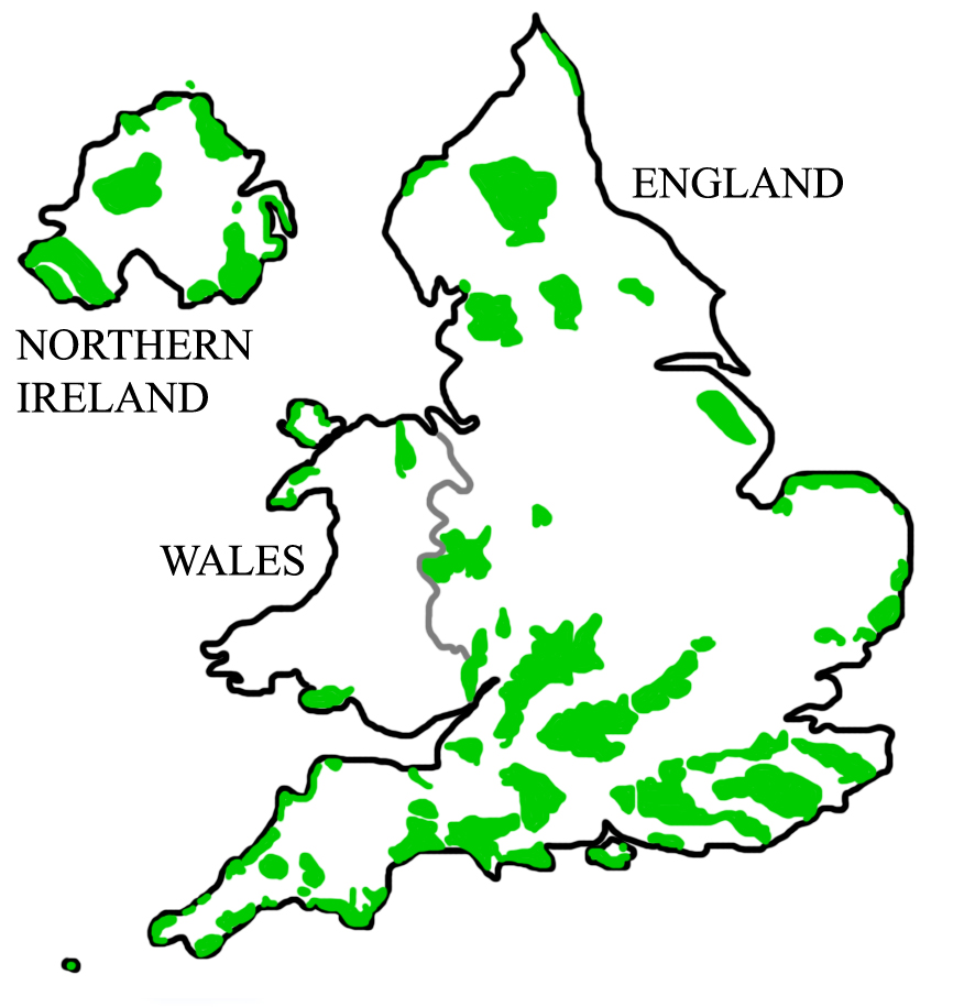
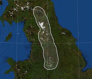 The Pennine Mountains of Northern England
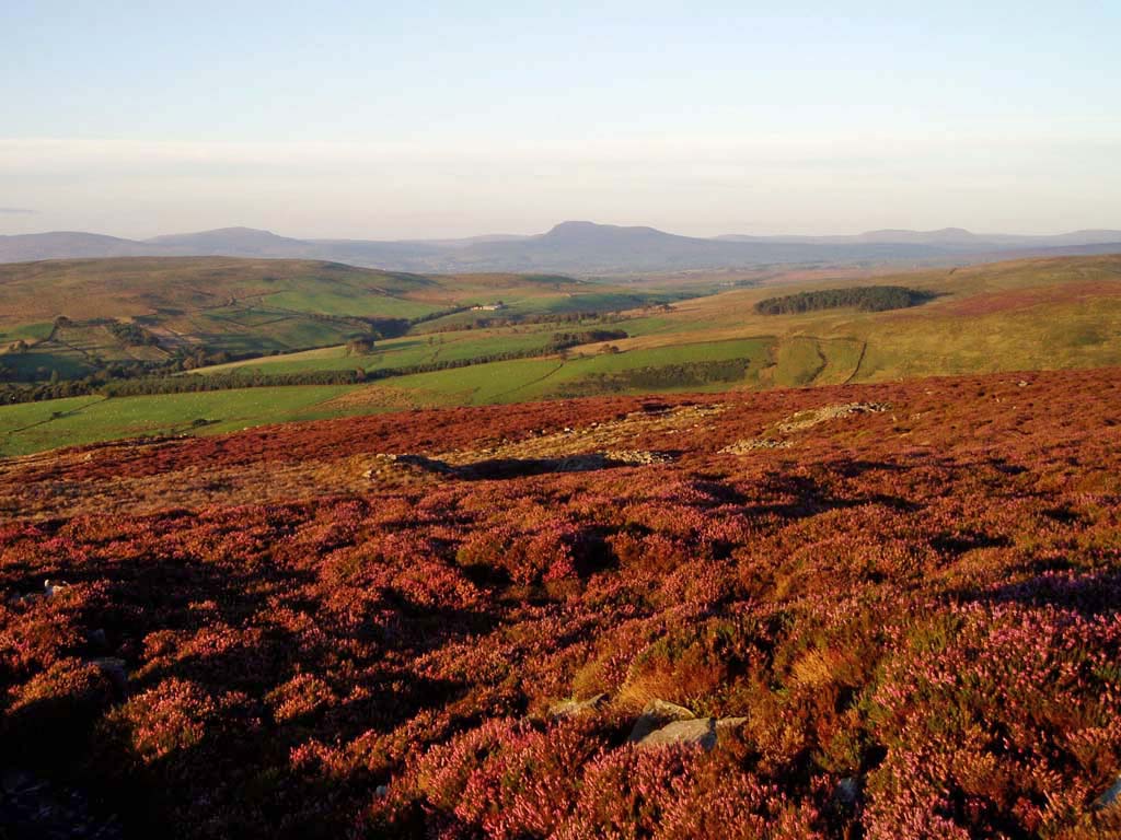
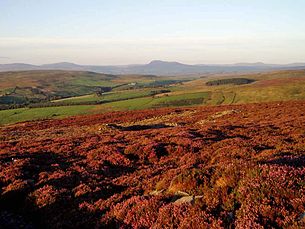 Typical Pennine scenery in the Forest of Bowland
The Pennines (English pronunciation: /ˈpɛnaɪnz/) are a low-rising mountain range, separating the North West of England from Yorkshire and the North East.
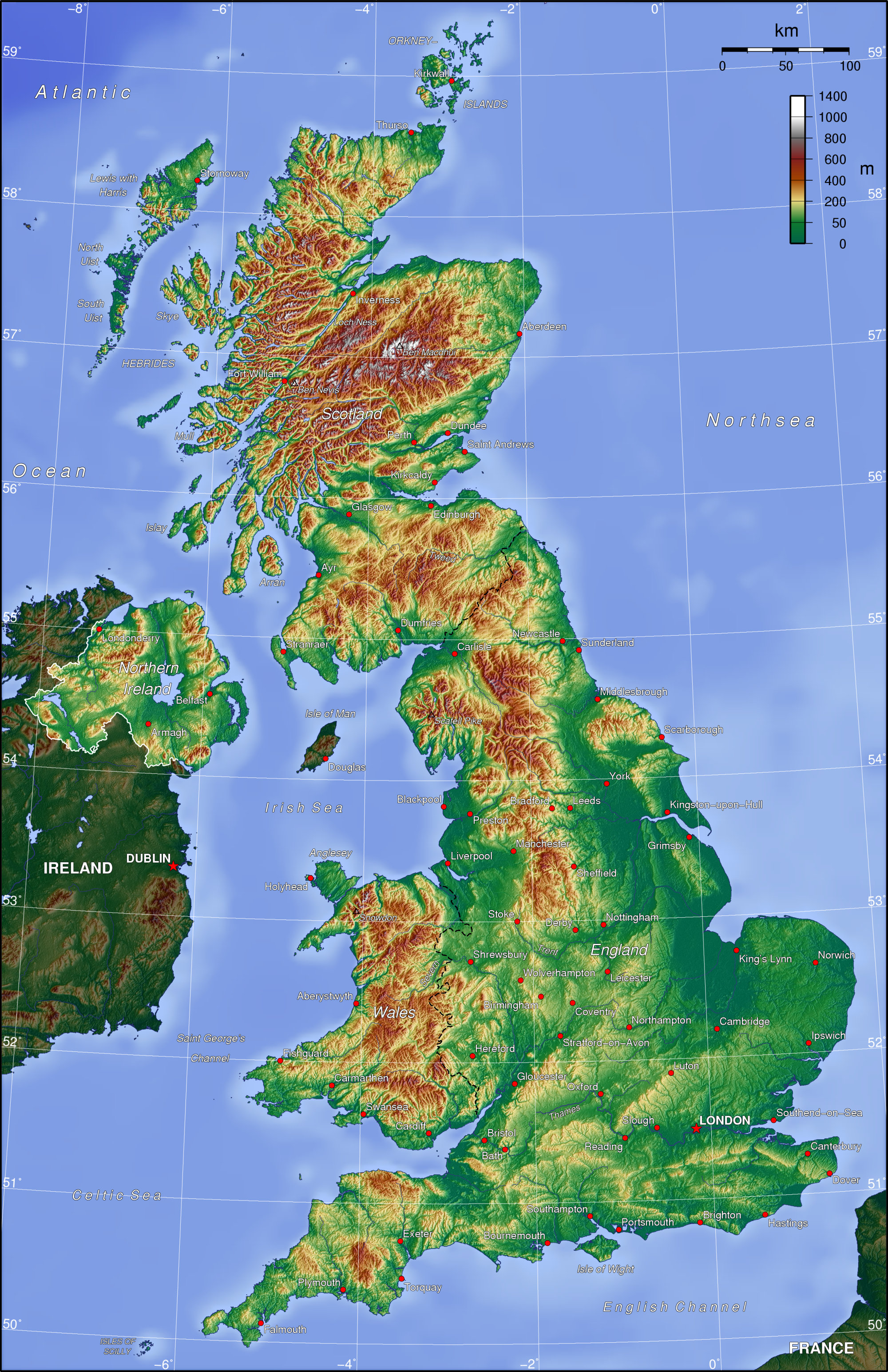
Often described as the "backbone of England",[1][2][3] they form a more-or-less continuous range stretching from the Peak District in Derbyshire, around the northern and eastern edges of Greater Manchester, through the Yorkshire Dales past the Cumbrian Fells to the Cheviot Hills on the Anglo-Scottish border. North of the Aire Gap, the Pennines give out a western spur into Lancashire, the Bowland Fells, and south of the gap is a similar spur, comprising the Rossendale Fells and West Pennine Moors.[4]
Although the above is a common definition, the Cheviot Hills are not, strictly speaking, part of the Pennines, being separated by the Tyne Gap and the Whin Sill, along which run the A69 and Hadrian's Wall, but because the Pennine Way crosses them they are often treated as such. Conversely, although the southern end of the Pennines is commonly said to be somewhere in the High Peak district of Derbyshire, often Edale (the start of the Pennine Way), they extend south into Staffordshire and the southern parts of Cheshire and Derbyshire. The true southern end of the Pennines is in the Stoke-on-Trent area, about 40 miles (64 km) south of Edale.
The Pennines are an important water catchment area with numerous reservoirs in the head streams of the major river valleys. The region is widely considered to be one of the most scenic areas of the United Kingdom.[5] The North Pennines and Nidderdale have been declared Areas of Outstanding Natural Beauty (AONB), as have Bowland and Pendle Hill. Portions of the Pennines are incorporated into the Peak District National Park, the Yorkshire Dales National Park and the Northumberland National Park.[6] Britain's first long distance footpath, the Pennine Way, runs along most of the Pennine chain and is 429 kilometres (268 mi) long.[7]
Etymology
The first use of the name "Pennines" to describe the mountain range is in the spurious De Situ Britanniae, first published in 1757:[8]
- This province is divided into two equal parts by a chain of mountains called the Pennine Alps, which rising on the confines of the Iceni and Carnabii, near the River Trivona (River Trent), extend towards the north in a continued series of fifty miles.
This book purported to contain the account of a Roman general preserved in the manuscript of a 14th-century English monk, Richard of Cirencester, and was considered the premier source of information on Roman Britain for more than a century after it was made available in 1749. It was in fact a forgery created by Charles Bertram, an Englishman then living in Copenhagen. In 1853, Arthur Hussey listed several names in De Situ Britanniae that he could not trace to an earlier source, including the "Pennine Alps".[9] However, by that time, particularly in the early 19th century, the name "Pennine Chain" or "Pennines" had become widely accepted.
In his 2004 book Names and History: People, Places and Things, George Redmonds provided a modern assessment.[10] He comments at length on the strange omission of the etymology of the Pennines in the serious literature regarding that area of England, including publications on place-name origins of Derbyshire and Lancashire by respected authors. He finally learns that the origin of the name is from De Situ Britanniae and that "nor do we know any name for the whole range before the 18th century." There follows a discussion of the forgery and the fact that a number of its inventions had found their way into the Ordnance Survey maps; and that the true origin of the name was known by serious authors, most of whom simply chose not to speak of it. He also notes that the mountains had been called by various names in the past, and that there were allusional references to the mountains as "our Apennines" as early as the 1630s (and perhaps before that), so likely Bertram simply invented a name that was easy for people to accept as fact.
Redmonds also suggests that Bertram may have got the idea for the name from the Elizabethan commentator William Camden, who wrote:
The north part...riseth up and swelleth somewhat mountainous, with moores and hills, which beginning here runs as an Apenine does in Italie, through the middest of England...even as far as Scotland, although oftentimes they change their name.[10]
The name 'Pennines' may have become readily accepted if it was already closely related to an earlier name (or names) for the hills of a Cumbric origin, like the hill Pen-y-ghent in northern Yorkshire. A very similar language to Cumbric was once spoken in Northern Italy. The etymology for the Apennines of Italy that is most frequently repeated (because of its semantic appropriateness) is that it derives from the Celtic Penn, 'mountain, summit':[11] which could have been assigned during the Celtic domination of north Italy in the 4th century BC or before. The name originally applied to the north Apennines. However, historical linguists have never found a derivation with which they are universally comfortable. Wilhelm Deecke said: "...is doubtful but some derive it from the Ligurian-Celtish Pen or Ben, which means mountain peak." [12] Ranko Matasović reconstructs a Proto-Celtic root *bando- 'peak, top',[13][14] which he considers of non-Indo-European origin.
Toponymy
The names of towns and geographical features retain some evidence of the Celts who were here before, and after, the Romans: for example the town Penrith, the fell Pen-y-ghent, the River Eden, or the name Cumbria. More commonly the local names result from the later Anglo-Saxon and Norse settlements. And in both Yorkshire and Cumbria many Norse words not commonly used in standard English are part of everyday speech: for example, gill (narrow steep valley), beck (brook or stream), fell (hill) and dale (valley).[15]
Geology and landscape
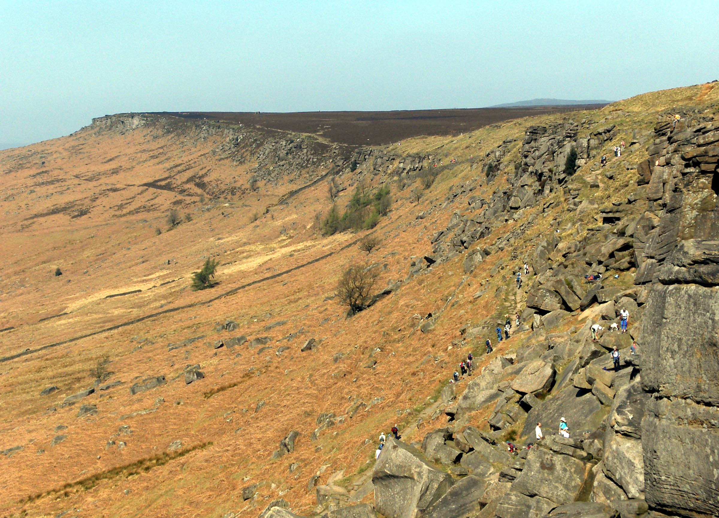
The Pennines have been carved from a series of geological structures whose overall form is that of a broad anticline whose axis extends in a north–south direction. The North Pennines are coincident with the Alston Block, whilst the Yorkshire Dales are coincident with the Askrigg Block. In the south the Peak District is essentially a flat-topped dome. Each of these structures consists of Carboniferous Limestone overlain with Millstone Grit. The limestone is exposed at the surface to the north of the range, in the North Pennines AONB, and to the south in the Derbyshire Peak District. In the Yorkshire Dales this limestone exposure has led to the formation of large underground cave systems and watercourses, known as "gills" and "pots" in the Yorkshire dialect. These caves, or "potholes", are more prevalent on the eastern side and are amongst the largest in England; notable examples are the chasms of Gaping Gill, which is over 350 ft (107 m) deep, and Rowten Pot, which is 365 ft (111 m) deep. Erosion of the limestone has also led to some unusual geological formations in the region, such as the limestone pavements of the Yorkshire Pennines. Between the northern and southern areas of exposed limestone (between Skipton and the Peak District) lies a narrow belt of exposed gritstone. Here, the shales and sandstones of the Millstone Grit form high hills occupied by a moorland of bracken, peat, heather and coarse grasses,[16] with the higher ground being uncultivable and barely fit for pastures.
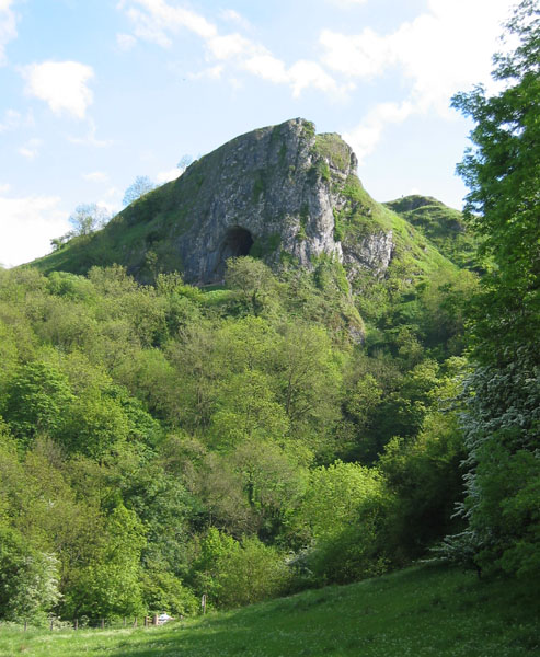
 Typical limestone scenery: Thor's Cave, Staffordshire, from the Manifold Way. Limestone is common in the White Peak and Yorkshire Dales, giving the two areas a distinction from other areas of the Pennines.
The landscape of the Pennines is characterised by upland areas of high moorland indented by more fertile river valleys.
Climate
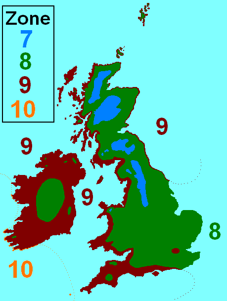
 Map of British Isles climatic zones. The Pennines are classified as zones 7 and 8, with 8 being milder areas and 7 being colder areas.
The climate of the Pennines is generally temperate like the rest of England, but they receive more precipitation, stronger winds and colder weather than the surrounding areas. Some areas of the Pennines could perhaps be described as temperate verging on subarctic in climate and indeed a small area of the Pennines is classified as subarctic, in certain parts of Teesdale. Snow falls in greater quantities in the Pennines than in surrounding lowland areas due to the elevation and distance from the coast; unlike lowland areas of England, the Pennines can actually have quite severe winters.
Precipitation is heavy, with North West England being amongst the wettest regions of England and much of that rain falling in the Pennines. The Pennines form two main watersheds, one leading to the Irish Sea and the other to the North Sea. The eastern side of the Pennines is drier than the western side and the Pennines "shield" North East England from much rainfall that would otherwise fall there. The precipitation in the Pennines is important for the biodiversity of the area and the human populations. Many towns and cities are along rivers that flow from the Pennines and in North West England the lack of natural aquifers is compensated for with many Pennine-based reservoirs. The wet climate has carved out gorges, caves and limestone landscapes in areas of the Pennines such as the Yorkshire Dales and Peak District and has had a mixed effect on the Pennines as a whole. In some areas the precipitation has contributed to poor soils, resulting in part in the moorland landscapes that characterize much of the range. In other areas where the soil has not been degraded, it has resulted in lush vegetation.
The Pennines come under climate zones 7 and 8, with 8 being common throughout most of the UK and 7 being the UK's coldest climatic zones. The Pennines, Scottish Highlands, Southern Uplands and Snowdonia are the only areas of the UK to be placed in the 7 climatic zone.
Climate data for Great Dun Fell, North Pennines (altitude 840m ASL) Month Jan Feb Mar Apr May Jun Jul Aug Sep Oct Nov Dec Year Average high °C (°F) 0.4
(32.7)−0.7
(30.7)2.2
(36.0)5.5
(41.9)8.5
(47.3)10.6
(51.1)12.4
(54.3)11.6
(52.9)10.1
(50.2)7.2
(45.0)3.9
(39.0)2.0
(35.6)6.14
(43.06)Daily mean °C (°F) −0.1
(31.8)0.3
(32.5)0.4
(32.7)3.4
(38.1)5.8
(42.4)8.6
(47.5)10.1
(50.2)10.3
(50.5)8.3
(46.9)5.7
(42.3)2.5
(36.5)0.5
(32.9)4.65
(40.37)Average low °C (°F) −1.5
(29.3)−1.2
(29.8)−1.3
(29.7)1.2
(34.2)3.3
(37.9)6.4
(43.5)8.0
(46.4)8.2
(46.8)6.3
(43.3)4.2
(39.6)1.0
(33.8)−1
(30.2)2.80
(37.04)Source: [17] Flora
Flora in the Pennines is adapted to moorland and subarctic landscapes and climates. The flora found there can be found in other areas of moorland in Northern Europe and some species are also found in areas of tundra.
In the Pennine millstone grit areas above an altitude of 275 m (902 ft) the topsoil is so acidic, pH 2 to 4, that it can grow only bracken, heather, sphagnum, and coarse grasses[16] such as cottongrass, purple moor grass and heath rush.[18]
As the Ice age glacial sheets retreated c. 11,500 BC trees returned and archaeological palynology can identify their species. The first trees to settle were willow, birch and juniper, followed later by alder and pine. By 6500 BC temperatures were warmer and woodlands covered 90% of the dales with mostly pine, elm, lime and oak. On the limestone soils the oak was slower to colonize and pine and birch predominated. Around 3000 BC a noticeable decline in tree pollen indicates that neolithic farmers were clearing woodland to increase grazing for domestic livestock, and studies at Linton Mires and Eshton Tarn find an increase in grassland species.[19]
On poorly drained impermeable areas of millstone grit, shale or clays the topsoil gets waterlogged in winter and spring. Here tree suppression combined with the heavier rainfall results in blanket bog up to 2 m (7 ft) thick. The erosion of peat ca 2010 still exposes stumps of ancient trees.[19]
“In digging it away they frequently find vast fir trees, perfectly sound, and some oaks…”Conifers have now been widely replanted as a cheap source of wood, especially around areas such as Kielder Forest.
Fauna
Fauna in the Pennines is similar to the rest of England and Wales, but the area hosts some specialised species. Deer are found throughout the Pennines and many species of animals that are rare elsewhere in England can be found here. Arctic Hares, which were common in Britain during the Ice Age and retreated to the cooler, more tundra-like uplands once the climate warmed up, were introduced to the Dark Peak area of the Peak District in the 19th century. Large areas of heather moorland in the Pennines are managed for driven shooting of wild Red Grouse.
Drainage
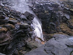 Kinder Downfall, a waterfall on Kinder Scout, Dark Peak
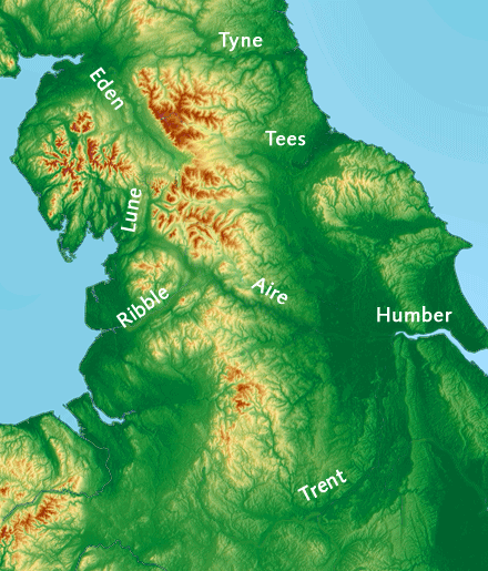
The Pennines constitute the main watershed in Northern England, dividing the eastern and western parts of the country. The rivers Eden, Ribble, Irwell and Mersey all rise in the Pennines and flow westwards towards the Irish Sea. On the other side of the watershed, the rivers Tyne, Tees, Wear, Swale, Ure, Nidd, Calder, Wharfe, Aire, Don and Trent also rise in the region but flow eastwards to the North Sea.
Reservoirs
Ladybower Reservoir and many other smaller reservoirs
Elevation
The mountains are not very high and are often referred to as fells. The highest is Cross Fell in eastern Cumbria, at 2,930 feet (893 m), while other principal peaks include Mickle Fell 2,585 ft (788 m), Whernside 2,415 ft (736 m), Ingleborough 2,372 ft (723 m), High Seat 2,328 ft (710 m) and Wild Boar Fell 2,324 ft (708 m), both in Mallerstang, Pen-y-ghent 2,274 ft (693 m), and Kinder Scout 2,087 ft (636 m).
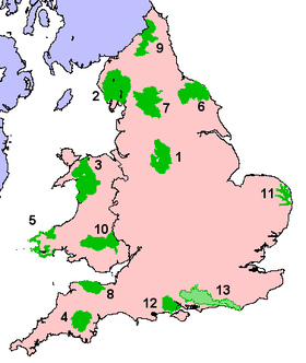
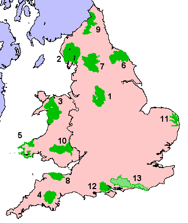
Character Areas of the Pennines
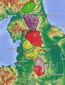 The Joint Character Areas of the Pennines
England has been divided into areas of similar landscape character. These were originally called Joint Character Areas (JCAs), but are now called National Character Areas (NCAs). The NCAs are a widely recognised national spatial framework, but the boundaries are not precise and many should be considered as broad zones of transition.[21]
The Pennines have eleven National Character Areas. These are:
- Border Moors and Forests[22]
- Tyne Gap and Hadrian's Wall[23]
- North Pennines[24]
- Howgill Fells[25]
- Yorkshire Dales[26]
- Bowland Fells[27] alongside the Bowland Fringe and Pendle Hill[28]
- Southern Pennines,[29] including the West Pennine Moors
- Dark Peak[30]
- White Peak[31]
- South West Peak[32]
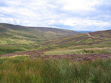 Croasdale Fell, Forest of Bowland.
The Bowland area of the Pennines is dominated by a central upland landform of deeply incised gritstone fells covered with vast tracts of heather-covered peat moorland and blanket bog. The lower slopes of the fells are dotted with stone-built farms and small villages and are criss-crossed by drystone walls enclosing reclaimed moorland pasture. Steep-sided wooded valleys link the upland and lowland landscapes. To the northeast of the area are extensive coniferous plantations and the eastern limestone areas support high-quality species-rich meadows.[33]
Dales
- Airedale
- Calderdale
- Dovedale
- Nidderdale
- Ribblesdale
- Swaledale
- Teesdale
- Weardale
- Wensleydale
- Wharfedale
Demography
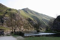 Pennines in Derbyshire
The Pennine region is relatively sparsely populated by English standards. Large population centres in the Pennines include Leeds and Bradford and a few towns bordering the Peak District, but the rest of the area is only thinly populated.
Economy
The main economic activities include sheep farming, quarrying, finance and tourism.
Main settlements
 The summit of Cross Fell with Great Dun Fell in the background.
- Sheffield
- Buxton
- Glossop
- Hawes
- Keld
- Leek
- Muker
- Reeth
- Stanhope
- Thwaite
- Leeds
- Alston
- Bradford
- Halifax
- Huddersfield
Transport
 By using these gaps a Pennine traverser does not have to climb above 228 m (748 ft) in the Tyne Gap, 409 m (1,342 ft) via the Stainmore Gap and only 179 m (587 ft) using the Aire Gap.[34]
The three main gaps in the Pennines have always afforded communications links between the areas to the east and west. These gaps are the Tyne Gap between Carlisle and Newcastle upon Tyne along which the A69 road and the Tyne Valley railway run, the Stainmore Gap between the Eden Valley in Cumbria and Teesdale in County Durham, and the Aire Gap linking Lancashire and Yorkshire via the valleys of the rivers Aire and Ribble. The Pennines are also traversed by the Leeds and Liverpool Canal and the M62 motorway. In many places, the Pennines remain a formidable barrier to be crossed by tunnel or roads that may be blocked by snow for several days in winter.
Rail services are operated along the Huddersfield line between Huddersfield and Victoria and Piccadilly stations in Manchester. The name of the train-operating company First TransPennine Express comes from such journeys - its trains connect the North West with the North East.
There are three trans-Pennine canals built during the Industrial Revolution which, as the name suggests, cross the range in various locations:
- The Huddersfield Narrow Canal connects the town of Huddersfield in the east with the city of Manchester in the west. When it reaches the Pennines at Marsden, it runs underneath the hills through a long tunnel to Diggle on the other side. Once a month during the summer season, it is possible to pass through the tunnel on a public narrowboat.
- The Rochdale Canal crosses the Pennines via Rochdale, connecting the market town of Sowerby Bridge with Manchester.
- The Leeds & Liverpool Canal, the longest and most northerly of the three, crosses the Pennines via Skipton connecting Leeds in the east with Liverpool in the west.
National Parks and AONBs
 The National Parks of England and Wales; the Pennines play host to three, those marked as 9, 7 and 1
Considerable areas of the Pennine landscapes are protected as UK national parks and Areas of Outstanding Natural Beauty (AONBs): Northumberland National Park (9), Yorkshire Dales National Park (7) and the Peak District National Park (1) and the North Pennines AONB. Areas of Outstanding Natural Beauty are afforded much the same protection as National Parks.
 England, Wales and Northern Ireland AONBs. The Pennines host two, with a large one protecting the North Pennines.
The North Pennines AONB just north of the Yorkshire Dales rivals the National Park in size and includes some of the Pennines' highest peaks and some of its most isolated and sparsely populated areas.
History
 A prehistoric settlement on Harkerside Moor in Swaledale.
Early inhabitants
The area contains many examples of Bronze Age settlements, and evidence of Neolithic settlement (including many stone circles or henges, such as Long Meg and Her Daughters).[35]
Celtic and Roman times
The Pennines would have come under the tribal federation of the Brigantes. This tribal federation was made up of mainly small tribes who inhabited the Pennines and cooperated on defence and external affairs. The Brigantes later evolved into an early form of kingdom.
During Roman times, the Brigantes came under Roman domination. The Romans exploited the Pennines for the natural resources and wild animals found there.
Early Middle Ages
The Pennines were a major obstacle for Anglo-Saxon expansion west, although it appears they travelled through the Pennine valleys. During the Dark Ages the Pennines came under a number of Celtic and Anglo-Saxon kingdoms. It is believed that the north of the area first came under the kingdom of Rheged. There were later three kingdoms that were solely based in the Pennines, however.[citation needed] These were: The Kingdom of the Pennines and later the Kingdom of the Pennines broke up[citation needed] and was succeeded by Dunoting/Kingdom of the North Pennines and The Peak/Kingdom of the South Pennines.
During Norse times the Pennines were settled by Viking Danes in the east and Norwegian Vikings in the west. The Vikings heavily influenced place-names, culture and genetics. When England was unified the Pennines were incorporated into it. The Pennines with their mixture of Celtic, Anglo-Saxon and Viking heritage resembled much of the rest of Northern England and the culture developed along with the area's lowland neighbours in North West and North East England. The Pennines did not form a distinct political entity of their own, but instead were subdivided between neighbouring counties in North East and North West England, with a major part being in the ceremonial county of Yorkshire.
Other history
The Pennines were the major route for the Jacobite attacks on England. They also became highly exploited in the Victorian era.
Language
The language used in pre-Roman and Roman times was British. During the Early Middle Ages, the Cumbric language developed. However, little evidence of Cumbric remains, so it is difficult to ascertain whether or not it was a language in its own right or simply a dialect of Old Welsh. It is also uncertain as to the extent of the region in which Cumbric was spoken.
During Anglo-Saxon times (the area was settled by Anglian peoples of Mercia and Northumbria, rather than the Saxon people of Southern England). Celtic speech remained in most areas of the Pennines longer than it did in the surrounding areas of England.[citation needed] Eventually, the Celtic tongue of the Pennines was replaced by early English as Anglo-Saxons and Vikings settled the area and assimilated the Celts.
In Norse times, Viking settlers brought their languages of Old Norse, Old Danish (mainly in the Yorkshire Dales and parts of the Peak District) and Old Norwegian (mainly in the western Pennines).[citation needed] With the eventual consolidation of England by the Saxon kingdom of Wessex, the pure Norse speech died out in England, though it survived in the Pennines longer than in most areas[citation needed]. However, the fusion of Norse and Old English was an important part of the formation of Middle (and hence, Modern) English, and many individual words of Norse descent remain in use in local dialects, such as that of Yorkshire, and in local place names.
Norman French had little effect on the language of the Pennines though.[citation needed] All of the above languages have had an influence, either large or small, on the modern placenames of the Pennines. The modern language of the Pennines is English.
Folklore and customs
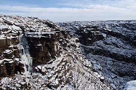 Dark Peak in winter
The folklore and customs are mostly based on Celtic, Anglo-Saxon and Viking customs and folklore.[citation needed] Many customs and stories have their origin in Christianised pagan traditions.[citation needed] In the Peak District a notable custom is well dressing, which has its origin in pagan traditions that became Christianized.
See also
- Geography of England
- Geology of the United Kingdom
- Geology of Yorkshire
- South Pennines
- White Peak
- Yorkshire Three Peaks
References
- ^ Poucher, W.A. (1946). The Backbone of England. A photographic and descriptive guide to the Pennine range from Derbyshire to Durham.. Guildford and Esher: Billing and Sons Limited
- ^ Edwards, W.; Trotter, F.M. (1975). The Pennines and Adjacent Areas. Handbooks on the Geology of Great Britain (Third ed.). London: HMSO (published 1954). p. 1. ISBN 0 11 880720 X
- ^ "Pennines -- Britannica Online Encyclopedia". http://www.britannica.com/eb/article-9059088/Pennines. Retrieved 2008-02-28.
- ^ Dudley Stamp, L (1946). "Britain’s Structure and Scenery". Nature. The Fontana New Naturalist Series (London and Glasgow: Collins) 158 (4023): 809. Bibcode 1946Natur.158..809T. doi:10.1038/158809a0
- ^ "Writer inspired by beauty of Pennines celebrates its views - Yorkshire Post". www.yorkshirepost.co.uk. http://www.yorkshirepost.co.uk/news/Writer-inspired-by-beauty-of.4564162.jp. Retrieved 2008-10-13.
- ^ "Designated Landscapes Index". Natural England. http://www.countryside.gov.uk/LAR/Landscape/DL/index.asp. Retrieved 2007-12-02.
- ^ "Trail stats, Pennine Way". National Trails Homepage. The Countryside Agency. http://www.nationaltrail.co.uk/PennineWay/text.asp?PageId=34. Retrieved 2007-08-03.
- ^ Bertram, Charles (1757). "Chapter XXXIII". In Hatcher, Henry. The Description of Britain, Translated from Richard of Cirencester. London: J. White and Co. 1809. p. 51. http://books.google.com/books?id=OwJIAAAAMAAJ&pg=PA51
- ^ Hussey, Arthur (1853). "A Renewed Examination of "Richard of Cirencester"". In Urban, Sylvanus. The Gentleman's Magazine. XXXIX. London: John Bowyer Nichols and Sons. pp. 270 – 273. http://books.google.com/books?id=DboUAAAAQAAJ&pg=PA272; discussing the so-called Iter VII: "... Alpes Peninos ..." not traced (to any earlier source).
- ^ a b Redmonds, George (2007-03-15). Names and History: People, Places and Things. Hambledon & London (published 2004). pp. 65–68. ISBN 185285426X. http://books.google.com/?id=Qxk8qK2uF7kC&pg=PA65&dq=Pennines&q=Pennines A Major Place-Name Ignored
- ^ Lewis, Charlton T.; Short, Charles (1879). "Apenninus". A Latin Dictionary. Oxford; Medford: Clarendon Press; Perseus Digital Library. http://www.perseus.tufts.edu/hopper/text?doc=Perseus%3Atext%3A1999.04.0059%3Aentry%3DApenninus.
- ^ Deecke 1904, p. 23
- ^ "unknown". http://www.indo-european.nl/cgi-bin/response.cgi?single=1&basename=\data\ie\celtic&text_recno=109&root=leiden.[dead link]
- ^ R. Matasović (2009): Etymological Dictionary of Proto-Celtic. Leiden-Boston: Brill. [ISBN 978-90-04-17336-1]
- ^ Gunn, Peter (1984). The Yorkshire Dales. Landscape with Figures. London: Century Publishing Co Ltd. ISBN 0 7126 0370 0
- ^ a b page 4 and page 5, Marginal Upland Grazing Sutton Moor, Domesday Reloaded, BBC 1986
- ^ "Regional mapped climate averages". The Met Office. August 2011. http://www.metoffice.gov.uk/climate/uk/averages/regmapavge.html#.
- ^ Kelsall, Dennis; Jan Kelsall (2008). The Yorkshire Dales: South and West. Milnthorpe: Cicerone. ISBN 978-1-85284-45-1.:26
- ^ a b White, Robert (2005) [1997]. The Yorkshire Dales, A landscape Through Time (new ed.). Ilkley, Yorkshire: Great Northern Books. ISBN 1-905080-05-0.
- ^ Arthur Young (1771) A Six Months' Tour of the North of England
- ^ "National Character Areas". Natural England. http://www.naturalengland.org.uk/ourwork/landscape/englands/character/areas/. Retrieved 2009-12-10.
- ^ "5 Border Moors and Forests". Natural England. http://www.naturalengland.org.uk/ourwork/landscape/englands/character/areas/border_moors_and_forests.aspx. Retrieved 2011-08-05.
- ^ "11 Tyne Gap and Hadrian's Wall". Natural England. http://www.naturalengland.org.uk/ourwork/landscape/englands/character/areas/tyne_gap_and_hadrians_wall.aspx. Retrieved 2011-08-05.
- ^ "10 North Pennines". Natural England. http://www.naturalengland.org.uk/ourwork/landscape/englands/character/areas/north_pennines.aspx. Retrieved 2011-08-05.
- ^ "18 Howgill Fells". Natural England. http://www.naturalengland.org.uk/ourwork/landscape/englands/character/areas/howgill_fells.aspx. Retrieved 2011-08-05.
- ^ "21 Yorkshire Dales". Natural England. http://www.naturalengland.org.uk/ourwork/landscape/englands/character/areas/yorkshire_dales.aspx. Retrieved 2011-08-05.
- ^ "34 Bowland Fells". Natural England. http://www.naturalengland.org.uk/ourwork/landscape/englands/character/areas/bowland_fells.aspx. Retrieved 2011-08-05.
- ^ "33 Bowland Fringe and Pendle Hill". Natural England. http://www.naturalengland.org.uk/ourwork/landscape/englands/character/areas/bowland_fringe_and_pendle_hill.aspx. Retrieved 2011-08-05.
- ^ "36 Southern Pennines". Natural England. http://www.naturalengland.org.uk/ourwork/landscape/englands/character/areas/southern_pennines.aspx. Retrieved 2011-08-05.
- ^ "51 Dark Peak". Natural England. http://www.naturalengland.org.uk/ourwork/landscape/englands/character/areas/dark_peak.aspx. Retrieved 2011-08-05.
- ^ "52 White Peak". Natural England. http://www.naturalengland.org.uk/ourwork/landscape/englands/character/areas/white_peak.aspx. Retrieved 2011-08-05.
- ^ "53 South West Peak". Natural England. http://www.naturalengland.org.uk/ourwork/landscape/englands/character/areas/south_west_peak.aspx. Retrieved 2011-08-05.
- ^ > "The Landscape of The Forest of Bowland Area Of Outstanding Natural Beauty (AONB)". Page managed by the Information Management Team in the Strategic Planning & Transport Section, Environment Directorate, Lancashire County Council. 06 June 2007. http://www.forestofbowland.com/wild_landscape.asp>. Retrieved 2007-12-07.[dead link]
- ^ Google earth.
- ^ "A landscape through time". Out of Oblivion. http://www.outofoblivion.org.uk/. Retrieved 2011-08-05.
- Arthur Raistrick, 'The Pennine Dales', Eyre Methuen Ltd 1968, ISBN 0-413-26760-1
External links
Categories:- Mountain ranges of Europe
- Mountains and hills of the Pennines
- Physiographic provinces


Wikimedia Foundation. 2010.