- Snowdonia
Geobox|Protected Area
name = Snowdonia
native_name =
other_name =
other_name1 =
category_local = National Park of Wales
category_iucn = V
image_size =
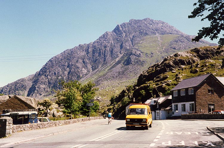
image_caption =Tryfan 's north ridge (seen on the left in this picture) in the Snowdonia National Park.
country = United Kingdom
country_
state = Wales
state_
state_type = Part
region = Gwynedd
region1 = Conwy County Borough
region2 =
region3 =
region4 =
region_type = Councils
city =
city1 =
location =
lat_d =
lat_m =
lat_s =
lat_NS =
long_d =
long_m =
long_s =
long_EW =
elevation =
biome =
biome_share =
biome1 =
biome1_share =
geology =
geology1 =
plant =
plant1 =
animal =
animal1 =
area = 2170
area1 =
area1_type =
length =
length_orientation =
width =
width_orientation =
highest = Snowdon
highest location =
highest_lat_d = 53.068865
highest_lat_m =
highest_lat_s =
highest_lat_NS = N
highest_long_d = 4.075588
highest_long_m =
highest_long_s =
highest_long_EW = W
highest_elevation = 1085
lowest =
lowest_location =
lowest_lat_d =
lowest_lat_m =
lowest_lat_s =
lowest_lat_NS =
lowest_long_d =
lowest_long_m =
lowest_long_s =
lowest_long_EW =
lowest_elevation =
established_type = National Park of Wales
established = 1951
established1_type =
established1 =
management_body =
management_location =
management_lat_d =
management_lat_m =
management_lat_s =
management_lat_NS =
management_long_d =
management_long_m =
management_long_s =
management_long_EW =
management_elevation =
visitation =
visitation_year =
free_type =
free =
free1_type =
free1 =
map_locator_x =
map_locator_y =
map_size =
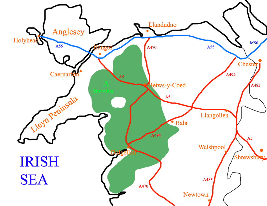
map_caption = A map of Snowdonia National Park shown in relation toNorth Wales .
map_first =
website =Snowdonia ( _cy. Eryri) is a region of
North Wales and anational park of convert|838|sqmi|km2|-1|lk=on in area. It was the first to be designated of the three National Parks in Wales, in 1951.Name and extent
The English name for the area derives from
Snowdon , which is the highestmountain inWales at convert|1085|m. In Welsh, the area is named "Eryri". One assumption is that the name is derived from "eryr" ("eagle"), but others state that it means quite simply "Highlands", as leading Welsh scholar SirIfor Williams proved. [Ifor Williams, "Enwau Lleoedd" (Liverpool, 1945), p.18. Compare the late professor's article in "Bulletin of the Board of Celtic Studies", vol. iv, pp. 137-41. The plural of Welsh "eryr" (eagle) is "eryrod" or "eryron", with no example of a form "eryri" being attested. A second word "eryr", plural "eryri", means "shingles" in modern Welsh; in the old Welsh place name this suggests uneven or upraised ground, a land of hills; "the uplands" or "highlands"] In theMiddle Ages the title "Prince ofAberffraw and Lord of Snowdon" ("Tywysog Aberffraw ac Arglwydd Eryri") was used by the hereditary rulers of theKingdom of Gwynedd ; for exampleLlywelyn Fawr .Today the word "Snowdonia" is largely synonymous with the Snowdonia National Park, although prior to the designation of the boundaries of the National Park, the term "Snowdonia" was generally used to refer to a smaller area, namely the more mountainous and northern areas closer to
Snowdon itself. This is apparent in books published prior to 1951 such as "Wild Wales" byGeorge Borrow (published by Collins, London in 1862) and "The Mountains of Snowdonia" by H. Carr & G. Lister (published by Lockwood, London in 1925). F. J. North, as editor of the book "Snowdonia" (published by Collins, London in 1949) states "When the Committee delineated provisional boundaries, they included areas some distance beyond Snowdonia proper."nowdonia National Park
Snowdonia National Park ( _cy. Parc Cenedlaethol Eryri) was established in 1951 as the third national park in
England andWales . It covers convert|2142|km2, and has convert|60|km of coastline.The park is governed by the
Snowdonia National Park Authority , which is made up of local government and Welsh national representatives, and its main offices are atPenrhyndeudraeth . Unlike national parks in other countries, Snowdonia (and other such parks in England and Wales) are made up of both public and private lands under central planning authority. The makeup of land ownership at Snowdonia is as follows:More than 26,000 people live within the park, of whom about 62% speak Welsh. The park attracts over 6 million visitors annually, split almost equally between day and staying visitors, making it the third most visited national park in England and Wales. [ [http://www.eryri-npa.gov.uk/page/index.php?nav1=learning&nav2=11&nav3=1&lang=eng&view=graphic&contrast=1 Snowdonia National Park Authority Website, Park Profile 2007] ]
Whilst most of the land is either open or mountainous land, there is a significant amount of agricultural activity within the park.
Since the local government re-organisation of 1998, the park lies partly in the county of
Gwynedd , and partly in the county borough of Conwy. It is governed by the 18–member Snowdonia National Park Authority, 9 of whom are appointed by Gwynedd, 3 by Conwy, and the remaining 6 by theNational Assembly for Wales .Unusually, Snowdonia National Park has a hole in the middle, around the town of
Blaenau Ffestiniog , aslate quarry ing centre. This was deliberately excluded from the park when it was set up in order to allow the development of new light industry to replace the decimated slate industry.Mountain ranges
Snowdonia may be divided into four areas:
*The northernmost area is the most popular with tourists, and includes (west to east):
**Moel Hebog ,Mynydd Mawr and theNantlle Ridge ; theSnowdon massif ; theGlyderau , and theCarneddau . These last three groups are the highest mountains inWales , and include all Wales' 3000-foot mountains.*The second area includes peaks such as
Moel Siabod ,Cnicht theMoelwynion , and the mountains aroundBlaenau Ffestiniog .*The third area includes the
Rhinogydd in the west as well as theArenig and theMigneint (this last being an area of bog). This area is not as popular with tourists as the other areas, due to its remoteness.*The southernmost area includes
Cadair Idris , the Tarren range, and the Aran group, includingAran Fawddwy , the highest mountain in the United Kingdom south of Snowdon.Mountain walking
Many of the hikers in the area concentrate on
Snowdon itself. It is regarded as a fine mountain, but can become quite crowded, particularly with theSnowdon Mountain Railway running to the summit.The other high mountains with their boulder-strewn summits, as well asTryfan , one of the few mountains in the UK south of Scotland the ascent of which needs hands as well as feet, are also very popular. However, there are also some spectacular walks in Snowdonia on the lower mountains, and they tend to be relatively unfrequented.Among hikers' favourites are Y Garn (east of Llanberis) along the ridge to
Elidir Fawr ; Mynydd Tal-y-Mignedd (west of Snowdon) along theNantlle Ridge to Mynydd Drws-y-Coed;Moelwyn Mawr (west of Blaenau Ffestiniog); andPen Llithrig y Wrach north ofCapel Curig . Further south areY Llethr in theRhinogydd , andCadair Idris nearDolgellau .The Park has convert|2381|km of public footpaths, convert|264|km of public
bridleway s, and convert|74|km of other public rights of way. A large part of the park is also covered byRight to Roam laws.Nature, landscape and the environment
The park's entire coastline is a
Special Area of Conservation , which runs from theLlŷn Peninsula down the Mid Wales coast, the latter containing valuable sand dune systems.The park's natural forests are of the mixed
deciduous type, the commonest tree being the Welsh Oak. Birch, ash, mountain-ash and hazel are also common. The park also contains some large (planted)coniferous forested areas such asGwydir Forest nearBetws-y-Coed , although some areas, once harvested, are now increasingly being allowed to regrow naturally.Northern Snowdonia is the only place in Britain where the
Snowdon Lily , anarctic-alpine plant, and the rainbow-colouredSnowdon beetle ("Chrysolina cerealis ") are found, and the only place in the world where the Snowdonia hawkweed, "Hieracium snowdoniense " grows.A large proportion of the park is today under designation (or under consideration for designation) as Sites of Scientific Interest,
National Nature Reserves ,Special Areas of Conservation ,Special Protection Areas ,Biosphere and Ramsar sites.One of the major problems facing the park in recent years has been the growth of "
Rhododendron ponticum ". This fast growing alien species has a tendency to take over and stifle native species from growing. It can form massive towering growths and has a companion fungus that grows on its roots producing toxins that are poisonous to any local flora and fauna for a seven–year period after the "Rhododendron" infestations have been eradicated. As a result there are a number of desolate landscapes.References
External links
* [http://www.eryri-npa.co.uk/ Snowdonia National Park Authority]
* [http://www.snowdonia-society.org.uk/ Snowdonia Society]
* [http://www.walkeryri.org.uk/ Photographs and walking guide to Snowdonia]
* [http://www.flickr.com/photos/davellandudno/sets/711616/ Photographs of Snowdonia]
* [http://www.snowdon.com/ Snowdon & Snowdonia Information]

Wikimedia Foundation. 2010.