- North Pennines
-
North Pennines 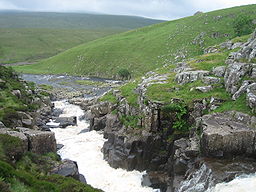 Cauldron Snout in the North Pennines AONB
Country England County County Durham, Northumberland, North Yorkshire, Cumbria Location North-east England Animal Red Squirrel The North Pennines is the northernmost section of the Pennine range of hills which runs north-south through northern England. It lies between Carlisle to the west and Darlington to the east. It is bounded to the north by the Tyne Valley and to the south by the Stainmore Gap.
Overview
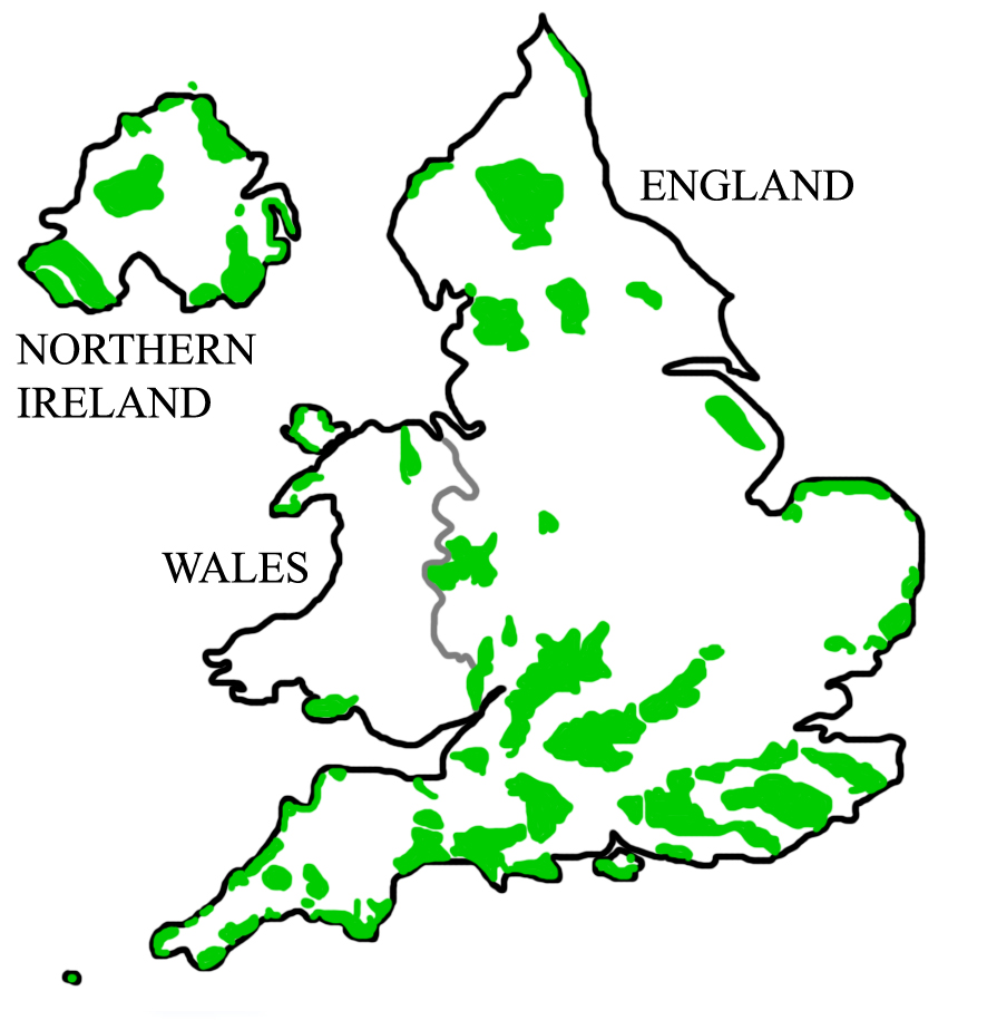
The North Pennines was designated as an Area of Outstanding Natural Beauty in 1988 for its moorland scenery, the product of centuries of farming and leadmining. At almost 2,000 square kilometres (770 sq mi) it is the second largest of the 49 AONBs in the United Kingdom.
The landscape of the North Pennines AONB is one of open heather moors between deep dales, upland rivers, hay meadows and stone-built villages, some of which contain the legacies of a mining and industrial past. The area shares a boundary with the Yorkshire Dales National Park in the south and extends as far as the Tyne Valley, just south of Hadrian's Wall in the north.
In the North Pennines are: 40% of the UK's upland hay meadows; 30% of England's upland heathland and 27% of its blanket bog; 80% of England's Black Grouse; Short-eared Owl, Ring Ouzel, Common Snipe and Common Redshank; 36% of the AONB designated as Sites of Special Scientific Interest; Red squirrels, otters and rare arctic alpine plants; 22,000 pairs of breeding waders and England's biggest waterfall - High Force.
One of the many walking routes in the North Pennines is Isaac's Tea Trail is a circular route of 58 kilometres (36 mi) around the area, running from Ninebanks via Allendale, Nenthead and Alston. In addition to this, a large section of the Pennine Way falls in the AONB, including one of the most celebrated stretches through Teesdale, a lush valley with dramatic river scenery including the twin attractions of High Force and Cauldron Snout.
The AONB is notable for rare flora and fauna, including wild alpine plants not found elsewhere in Britain. It is also home to red squirrels and diverse birds of prey. The impressive landscape of the North Pennines - from High Force on the River Tees to the sweeping valley of High Cup Gill above Dufton - are the product of millions of years of geological processes. The worldwide significance of the geology found in the area was recognised in 2003 when the AONB became Britain's first European Geopark. A year later the area become one of the founding members of the UNESCO-assisted Global Geopark family. Geoparks are areas with outstanding geological heritage where this is being used to support sustainable development.
Another of the North Pennines' oddities is that it is home to England's only named wind, the Helm Wind. It has caught out many walkers traversing the plateaux around Cross Fell, the Eden Valley fellside, and the valleys in between Alston and Dufton.
The great English poet W. H. Auden spent much time in this area and some forty poems and two plays are set here. He referred to the region as his "Mutterland", his "great good place", and equated it with his idea of Eden. Scores of Pennine place-names are found in his work, including Cauldron Snout and Rookhope
External links
East of England 
East Midlands North East Northumberland Coast | North PenninesNorth West South East South West West Midlands Yorkshire and Humber Categories:- Areas of Outstanding Natural Beauty in England
- Mountains and hills of the Pennines
- Global Geoparks Network members
- Protected areas of County Durham
- Protected areas of Northumberland
- Protected areas of North Yorkshire

Wikimedia Foundation. 2010.