- Cranborne Chase and West Wiltshire Downs
-
Coordinates: 50°57′41″N 2°02′39″W / 50.96142°N 2.04409°W
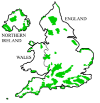
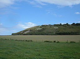
Cranborne Chase and West Wiltshire Downs Area of Outstanding Natural Beauty Fovant Badges on the West Wiltshire DownsCountry England Counties Dorset, Hampshire, Somerset and Wiltshire Location south-west England Highest point Win Green - elevation 277 m (909 ft) The Cranborne Chase and West Wiltshire Downs Area of Outstanding Natural Beauty (AONB) covers 379 square miles (980 km2) of Dorset, Hampshire, Somerset and Wiltshire. It is the sixth largest AONB in the country.
The landscape is mainly chalk downland that is farmed. Settlers populated the area thousands of years ago and constructed Ackling Dyke and the Knowlton Circles. The area was later the scene of conflict in the English Civil War, seeing the destruction of Old Wardour Castle. Other features include Tollard Royal, once considered the capital of Cranborne Chase; and Fovant, where soldiers training during the First World War cut regimental badges into the chalk hillside.
This AONB includes two large blocks of woodland, Grovely Wood and Great Ridge Wood.
External links
- Cranborne Chase and West Wiltshire Downs AONB website
- Cranborne Chase AONB Woodfair
- Historic Landscape Characterisation - Explore the history and archaeology of the AONB
East of England 
East Midlands North East North West South East South West Blackdown Hills | Cranborne Chase and West Wiltshire Downs | Cornwall | Cotswolds | Dorset | East Devon | Isles of Scilly | Mendip Hills | North Devon Coast | North Wessex Downs | Quantock Hills | South Devon | Tamar ValleyWest Midlands Yorkshire and Humber Categories:- Areas of Outstanding Natural Beauty in England
- Protected areas of Dorset
- Protected areas of Hampshire
- Protected areas of Somerset
- Protected areas of Wiltshire
- Wiltshire geography stubs
Wikimedia Foundation. 2010.

