- Norfolk Coast AONB
-
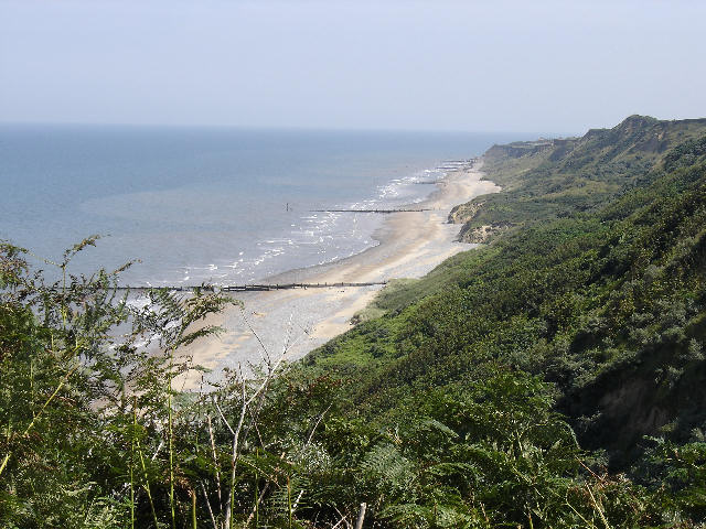
Norfolk Coast Area of Outstanding Natural Beauty  The Norfolk Coast east of Cromer
Country England County Norfolk Location East Anglia Animal Black-headed Gull, Bluethroat, Common Seal, Grey Seal, Natterjack Toad, Pied Flycatcher, Wheatear, Whinchat Founded 1968 The Norfolk Coast Area of Outstanding Natural Beauty (AONB) covers over 450 km2 of coastal and agricultural land from the The Wash in the west through coastal marshes and cliffs to the sand dunes at Winterton in the east.
The area includes; Hunstanton, Wells-next-the-Sea, Blakeney, Blakeney Point, Sheringham, Cromer and Mundesley. The terrain behind the coast is rolling chalk land and glacial moraine, including the almost 300 foot (90m) high Cromer Ridge. East of Weybourne there is severe coastal erosion.
National Nature Reserves in the AONB include the world-famous bird reserves at Cley Marshes and Titchwell. The Winterton Dunes are one of the country's finest dune systems. The Heritage Coast stretch of the AONB is a Site of Special Scientific Interest, a candidate Special Area for Conservation (SAC) and a Special Protection Area. The Peddars Way and Norfolk Coast Path National Trail pass through the AONB.
External links
East of England Dedham Vale | Norfolk Coast | Suffolk Coast and Heaths
East Midlands North East North West South East South West West Midlands Yorkshire and Humber Coordinates: 52°58′N 0°59′E / 52.97°N 0.98°E
Categories:- Environment of Norfolk
- Areas of Outstanding Natural Beauty in England
- Protected areas established in 1968
- Protected areas of Norfolk
- Coastal feature of Norfolk
- Norfolk geography stubs
Wikimedia Foundation. 2010.