- Geology of Dorset
-
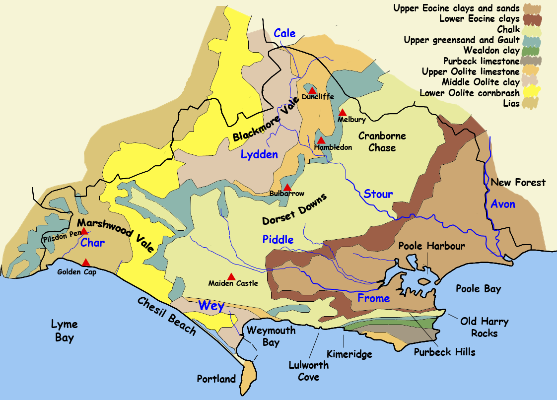
 Geology map of Dorset
Dorset, England, rests on a variety of different rock types which give the county its interesting landscapes and habitats.[1] Dorset is particularly noted for its coastline, the Jurassic Coast, which in 2001 was designated a World Heritage Site because of the variety of landforms and fossils exhibited along the coast. 44% of the county is within the Dorset AONB, which includes most of the Downs, Blackmore Vale, Purbecks, the Chesil Beach and Fleet SSSI and Poole Harbour.
Contents
Downland
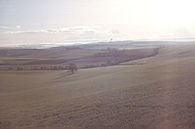
Throughout Dorset there are a number of limestone ridges. These ridges support arable agriculture and calcareous grassland habitats, as well as aquifers. The largest and most notable of the limestone bands is the band of Cretaceous chalk which runs from the south west to the north east of the county and forms part of the Southern England Chalk Formation which underlies much of south of England, including Salisbury Plain, the Isle of Wight and the South Downs. The central Dorset section of the chalk formation is known as the Dorset Downs, and the north eastern section, which runs into Wiltshire, as Cranborne Chase. The two are separated by the Stour Valley which cuts through the hills at Blandford Forum. In the Isle of Purbeck is another, smaller, ridge of the chalk formation, known as the Purbeck Hills.
The high chalk hills were important in the pre-Roman history of Dorset, the location of settlements in the Neolithic, Bronze Age and Iron Age, and are noted for the hill forts at Maiden Castle, Hambledon Hill and Badbury Rings and for the Cerne Abbas giant chalk hill figure. Running through the chalk hills are a number of winterbourne valleys.
Valleys
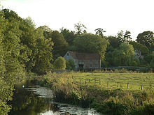
Between the bands of limestone and chalk are wide Tertiary clay vales with large flood plains, which sustain many small settlements and dairy farms. The most notable of the valleys are those of the Stour and Frome. The Stour flows into the north of the county at Gillingham, into a wide basin, the Blackmore Vale, where it collects from many small tributaries. The river then flows south, through a gap in the chalk and across the healthand of south east Dorset. The Frome collects water from the aquifer of the Dorset Downs, forming in the hills in west Dorset, and flowing through Dorchester into a wide estuary, Poole Harbour, where it reaches the weak sands in the south east of the county.
Heathland

South-east Dorset, around Poole and Bournemouth, and the New Forest, lie on very unresistant Tertiary beds: Eocene clays (mainly London Clay and Gault Clay), sands and gravels. These thin soils support a heathland habitat which supports all six native British reptile species. Dorset Heath, a species of the genus Erica, grows in this area, and in 2002 was chosen as a symbol of the county by Plantlife's "county flower" competition.
The River Frome estuary runs through this weak rock, and its many tributaries have carved out a very wide estuary. At the mouth of the estuary sand spits have been deposited turning the estuary into Poole Harbour, the second largest natural harbour in the world (after Sydney Harbour, though since artificial expansion Sydney's claim is disputed). The harbour is very shallow in places and contains a number of islands, notably Brownsea Island, famous for its Red Squirrel sanctuary and as the birthplace of the Scouting movement.
The harbour, and the chalk and limestone hills of the Purbecks to the south, lie atop Britain's largest onshore oil field. The field, operated by BP from Wytch Farm, produces a high-quality oil and has the world's oldest continuously pumping well (Kimmeridge, since the early 1960s) and longest horizontal drill (5 miles, ending underneath Bournemouth pier). The clay pottery produced by Poole pottery from the local clays is famous for its quality.
Coastline
Dorset's coastline is one of the most visited and studied coastlines in the world because it shows, along the course of 95 miles (153 km) (including some of east Devon) rocks from the beginning of Triassic, through the Jurassic and up to the end of the Cretaceous, documenting the entire Mesozoic era with well preserved fossils. Particularly famous are the Triassic and Jurassic cliffs around Lyme Regis which have yielded many notable fossil finds, including Mary Anning's Ichthyosaur. The variety of geology leads to a variety of habitats, from the heathland of the Tertiary beds at Poole Harbour and Studland, to the Chalk downland where the Cretaceous beds reach the sea. There are also small areas of karst landscape on the Jurassic limestones.
What makes Dorset's coast particularly important to geologists though are the series of landforms which occur so close together, on the concordant and discordant coastlines. The most famous include Lulworth Cove, Durdle Door natural arch, Old Harry Rocks and Chesil Beach, a tombolo. The Portland limestone of the Isle of Portland and the Purbeck Limestone of the Isle of Purbeck have been quarried for use in building much of London and hundreds of thousands of British war grave stones and memorials.
See also
- Geology of England
- Geology of the United Kingdom
- List of Dorset beaches
- List of places on the Jurassic Coast
Notes
References
- Arkell, W.J., 1978. The Geology of the Country around Weymouth, Swanage, Corfe & Lulworth. London: Geological Survey of Great Britain, HMSO.
- Bird, Eric, 1995. "Geology and scenery of Dorset". Bradford on Avon: Ex Libris Press. ISBN: 0948578726
- Davies, G.M., 1956. A Geological Guide to the Dorset Coast, 2nd ed. London: A & C Black.
- Encyclopædia Britannica, 1911. Dorsetshire. [1]
- Perkins, John W., 1977. Geology Explained in Dorset. London: David & Charles.
- West, Ian, 2004. Geology of the Wessex Coast and Southern England. Southampton University [2] (Accessed between September 2003 and October 2004).
Ceremonial county of Dorset Dorset Portal Unitary authorities Bournemouth · PooleBoroughs or districts Major settlements Beaminster · Blandford Forum · Bournemouth · Bridport · Chickerell · Christchurch · Dorchester · Ferndown · Gillingham · Lyme Regis · Poole · Portland · Shaftesbury · Sherborne · Stalbridge · Sturminster Newton · Swanage · Upton · Verwood · Wareham · Weymouth · Wimborne Minster
See also: List of civil parishes in DorsetRivers Topics Beaches · County Council · Flag · Geology · History · Lord Lieutenants · Museums · People · Places · Settlements · SSSIs · Transport


Wikimedia Foundation. 2010.