- Stainmore
-
- For other uses of Stainmore see Stainmore (disambiguation)
Coordinates: 54°31′40″N 2°15′35″W / 54.527879°N 2.259772°W
Stainmore 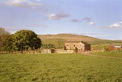
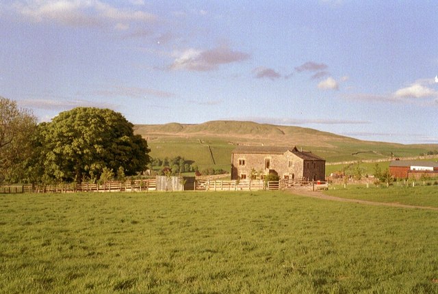
Mousegill, with Great Knipe behind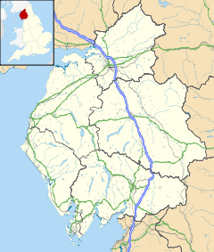
 Stainmore
Stainmore shown within CumbriaPopulation 253 (2001) OS grid reference NY8314 Parish Stainmore District Eden Shire county Cumbria Region North West Country England Sovereign state United Kingdom Post town KIRKBY STEPHEN Postcode district CA17 Dialling code 01768 Police Cumbria Fire Cumbria Ambulance North West EU Parliament North West England UK Parliament Penrith and The Border List of places: UK • England • Cumbria Stainmore is a civil parish in the Eden District of Cumbria, England, including the villages of North Stainmore and South Stainmore. It has a population of 253.[1]
Contents
Geography
Stainmore is drained by the River Belah and the River Balder. It is crossed by the Roman road from Bowes to Brough, now part of the A66, and formerly by the Stainmore Railway. Each of these lines of communication has made use of the relatively low broad saddle between the higher hills to north and south which is commonly referred to as the Stainmore Gap. The summit of the former railway is around 420m above sea level, though the roads climb to slightly higher elevations.[2] The Gap is coincident with the Stainmore Summit Fault which throws the relatively flat-lying Carboniferous rocks of the area down to the south.[3] It acted as a conduit for Lake District-originated ice to pass eastwards during one or more glacial periods. There are several RIGS sites in the Stainmore area.
History
According to Roger of Wendover, it was where Eric Bloodaxe (d. 954), recently expelled from York, was betrayed and killed, an event which some historians believe to have taken place in a great battle. Ancient monuments include a Roman marching camp at Rey Cross (54°30′25″N 2°09′19″W / 54.5070°N 2.1552°W), and the Rey Cross itself (54°30′21″N 2°08′55″W / 54.50579°N 2.14867°W), also called Rere Cross (Scheduled monument, no. 32713).[4]
References
- ^ Office for National Statistics : Census 2001 : Parish Headcounts : Eden Retrieved 26 October 2010
- ^ Ordnance Survey 1:25,000 scale Explorer map sheet OL19 Howgill Fells & Upper Eden Valley
- ^ British Geological Survey 1:50,000 scale geological map sheet no 31 (England & Wales) Brough-under-Stainmore
- ^ Rey Cross Roman Marching Camp
Further reading
- Collingwood, W.G. "Rey-Cross." Transactions of the Cumberland and Westmorland Antiquarian Archaeological Society series 2, 27 (1927): 1–10.
- Pearsall, W.H. The "Mosses" of the Stainmore district, Journal of Ecology, 1941
- Ramsden, D.M. From Stainmore to the Tees. Clapham, 1948.
- Richmond, I.A. and McIntyre, J. "The Roman marching camps at Reycross and Crackenthorpe." Transactions of the Cumberland and Westmorland Antiquarian Archaeological Society series 2, 34 (1934): 50–61.
- Robinson, P. Archaeology on the Stainmore Pass – the A66 Project. Barnard Castle, 1993.
- Vyner, B. (ed.). Stainmore. The Archaeology of a North Pennine Pass. Tees Archaeology Monographs 1. Hartlepool, 2001.
Ceremonial county of Cumbria Boroughs or districts Major settlements - Alston
- Ambleside
- Appleby-in-Westmorland
- Aspatria
- Barrow-in-Furness
- Bowness-on-Windermere
- Brampton
- Broughton-in-Furness
- Carlisle
- Cleator Moor
- Cockermouth
- Dalton-in-Furness
- Egremont
- Grange-over-Sands
- Harrington
- Kendal
- Keswick
- Kirkby Lonsdale
- Kirkby Stephen
- Longtown
- Maryport
- Millom
- Penrith
- Sedbergh
- Silloth
- Ulverston
- Whitehaven
- Wigton
- Windermere
- Workington
See also: List of civil parishes in Cumbria
Topics Categories:- Mountains and hills of County Durham
- Geography of Cumbria
- Scheduled Ancient Monuments in Cumbria
- Scheduled Ancient Monuments in North Yorkshire
- Civil parishes in Cumbria
- Cumbria geography stubs

Wikimedia Foundation. 2010.