- Ninebanks
-
Coordinates: 54°52′33″N 2°20′11″W / 54.8757°N 2.3365°W
Ninebanks 
Ninebanks Tower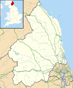
 Ninebanks
Ninebanks shown within NorthumberlandOS grid reference NY785535 Unitary authority Northumberland Ceremonial county Northumberland Region North East Country England Sovereign state United Kingdom Postcode district NE47 Police Northumbria Fire Northumberland Ambulance North East EU Parliament North East England UK Parliament Hexham List of places: UK • England • Northumberland Ninebanks is a small village in south west Northumberland, England in the North Pennines Area of Outstanding Natural Beauty 8 miles (13 km) north-east of Alston by road. It is noted for the early sixteenth century Ninebanks Tower, sometimes described as a pele tower, but possibly built as a watchtower.[1] It is made of sandstone and has four floors, the lowest of which is now below the level of the road. YHA Ninebanks is a youth hostel situated outside the hamlet at the settlement of Mohope about 1 mile (1½ km) away.
Notable people
Isaac Holden, was born at Redheugh, Mohope around 1804 and baptised nearby at St. Mark's church, Ninebanks in 1805. He was a local philanthropist and a Methodist. His working life began in the lead mines of Mohope and the West Allen, later on he became an itinerant tea seller around the North Pennines. It was a livelihood he combined with community fund raising by selling poems, tracts and even his own portrait. Evidence of his contribution to community life can be seen in the old hearse house at Ninebanks. This was built to keep the "Holden hearse", which he presented to the people of the West Allen valley in 1856. It was his final act of generosity, as he died the following year. The stone built hearse house can still be seen past St. Mark's Church and the old school at Ninebanks and on the same side of the road to Carrshield. There is also a commemorative memorial to Isaac Holden in St. Cuthbert's churchyard in Allendale. The 36-mile (58 km) Isaac's Tea Trail is a circular walk named after him - Isaac's Tea Trail. This passes near the hamlet of Ninebanks.
References
External links
- GENUKI (accessed: 26 November 2008)
Cumbria 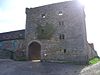
Durham Northumberland Beltingham • Black Middens Bastle House • Chillingham • Edlingham Castle • Haltwhistle • Housesteads • NinebanksScotland Glenae Tower • Kinnelhead Bastle-House • Lowther HillsSee also: Barmkin • Border Reivers • Peel tower • Tower house • Tower houses in the British Isles Categories:- Villages in Northumberland
- Youth hostels
- Northumberland geography stubs


Wikimedia Foundation. 2010.