- Mickle Fell
-
Mickle Fell 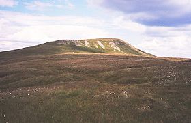
Western side of Mickle FellElevation 788 m (2,585 ft) Prominence c. 210 m Parent peak Cross Fell Listing Marilyn, Hewitt, County Top, Nuttall Location Location Pennines, England Topo map OS Landrangers 91, 92 OS grid NY804243 Mickle Fell is a mountain in the Pennines, the range of hills and moors running down the middle of Northern England. It is 788 m (2,585 ft) high and lies slightly off the main watershed of the Pennines, about ten miles south of Cross Fell.
It is the highest point of both the ceremonial county of County Durham and the historic county of Yorkshire,[note 1] lying in the southern part of Teesdale which was transferred from the North Riding of Yorkshire to County Durham under the Local Government Act 1972.
The name of Mickle Fell comes from the Old Norse word Mikill meaning Great and Fell (or fjäll) meaning mountain or hill.
The fell lies in the middle of a large area of boggy moor and requires a long hike to get to it from any direction. Mickle Fell's distinctive outline makes it a recognisable object in views from the Lake District hills, particularly Blencathra, the Helvellyn range and High Street. South of Mickle Fell the ridge descends to the Stainmore Gap before rising again into the Yorkshire Dales.
Mickle Fell and surrounding moorland forms part of the Warcop Training Area, a Ministry of Defence firing range. As a result, access to the fell is limited.[1] It can be ascended from the Eden Valley to the west, or from Teesdale to the east.
Marilyns are scarce in the North Pennines because of the relative flatness of the moors, but Mickle Fell is one such hill: it is separated from its neighbours by over 200 m of relative height.
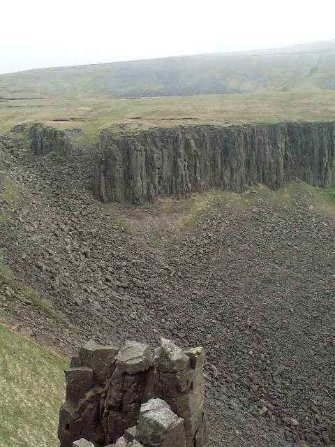
High Cup
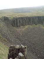 High Cup Nick
On the moor to the west of Mickle Fell between Murton Fell and Dufton Fell is a remarkable natural formation known as High Cup — a vast 'hole' in the moorside, similar in form to an elongated crater. A waterfall at the head of the Cup is called High Cup Nick. The feature is well seen from the A66 road. The Pennine Way goes past High Cup on its cross-watershed trek from Middleton-in-Teesdale to Dufton.
References
Notes
- ^ Whernside is the highest point within the boundaries of the ceremonial county of North Yorkshire.
Coordinates: 54°36′48″N 2°18′18″W / 54.61347°N 2.30500°W
Marilyns Hewitts Bink Moss · Black Fell · Burtree Fell · Chapelfell Top · Dead Stones · Flinty Fell · Great Dun Fell · Great Stony Hill · Grey Nag · Killhope Law · Knock Fell · Little Dun Fell · Little Fell · Meldon Hill · Melmerby Fell · Murton Fell · Round Hill · The Dodd · Three Pikes · Viewing Hill · Westernhope MoorOther hills Knock PikeCategories:- Marilyns of England
- Hewitts of England
- Mountains and hills of the Pennines
- Mountains and hills of County Durham
- Nuttalls
- Mountains and hills of Yorkshire

Wikimedia Foundation. 2010.