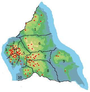
- Old Man of Coniston
-
Old Man of Coniston Cumbria,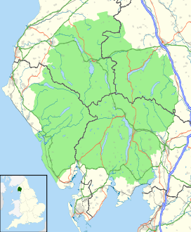
 Old Man of Coniston
 England
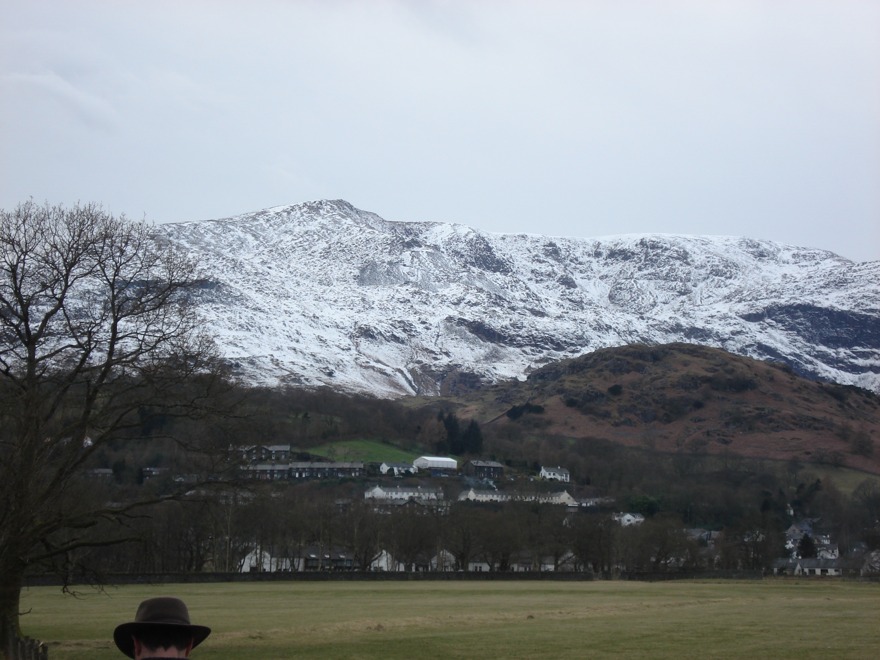
Elevation 2,634 ft (803 m) Prominence 416 m (1,365 ft) Parent peak Scafell Pike Listing Hewitt, Marilyn, Nuttall, Wainwright Location Range Lake District, Southern Fells Coordinates 54°22′N 3°07′W / 54.37°N 3.119°WCoordinates: 54°22′N 3°07′W / 54.37°N 3.119°W Topo map OS Landranger 90, Explorer OL6 OS grid SD272978 The Old Man of Coniston is a fell in the Furness Fells in the English Lake District. It is 2,634 feet (803 m) high, and lies to the west of the village of Coniston and the lake of the same name, Coniston Water. The fell is sometimes known by the alternate name of Coniston Old Man, or simply The Old Man. The mountain is a popular with tourists and fell-walkers with a number of well-marked paths to the summit. The mountain has also seen extensive slate mining activity for eight hundred years and the remains of abandoned mines and spoil tips are a significant feature of the north east slopes. There are also several flocks of sheep that are grazed on the mountain.[1]
Contents
Highest Fell in the Range?
The Old Man is the highest point in historical Lancashire, though following the 1974 revision of county boundaries in England it now lies, for administrative purposes, within Cumbria. This assertion rests upon its being higher than its near northern neighbour, Swirl How. There appears to be some doubt in the current literature over whether the height of Swirl How is 802 or 804 m, following resurveying. If modern measurement has not added 2 m to its rival then The Old Man of Coniston is the highest point in the Furness Fells, and the twelfth most prominent mountain in England.[2]
Topography

The Coniston (or Furness) Fells form the watershed between Coniston Water in the east and the Duddon valley to the west. The range begins in the north at Wrynose Pass and runs south for around 10 miles (16 km) before petering out at Broughton in Furness on the Duddon Estuary. Alfred Wainwright in his influential Pictorial Guide to the Lakeland Fells took only the northern half of the range as Lakeland proper, consigning the lower hills southward to a supplementary work The Outlying Fells of Lakeland. Later guidebook writers have chosen to include the whole range in their main volumes.[3][4]
The central part of the Coniston range can be likened to an inverted 'Y' with Brim Fell at the connecting point of the three arms. The main spine of the ridge runs north over Swirl How and Great Carrs and south west to Dow Crag and the lower hills beyond. The third arm is a truncated spur, running only half a mile to the summit of the Old Man before tumbling away south eastward to the valley floor. This ridge end position gives the fell a sense of isolation and increased stature, with steep faces on three sides.
To the west is the deep trench containing Goat’s Water. This elongated tarn has a depth of about 50 ft (15 m). and contains trout and char. Enclosed by high ground, it has an outlet to the south through a field of boulders.[5] This is one of the headwaters of Torver Beck, which passes a disused quarry near the Tranearth climbing hut, keeping the workings topped up via an artificial but extremely picturesque waterfall. The stream finally issues into Coniston Water to the south of Torver village.[3]
The southern and eastern flanks of The Old Man are composed of rough ground, deeply pockmarked by slate quarries. One of these quarries, Bursting Stone, is still operating to produce an olive green slate. Across the southern slopes runs the Walna Scar Road. This was the original trade route between Coniston village and the settlements of the Duddon Valley and is a public byway open to all traffic.[6]
The first section rising steeply from Coniston is a metalled road, maintained partly to provide access to the quarry. This leads to a carpark at an altitude of 740 ft (230 m), a popular starting point for climbs. Beyond here motor vehicles are prohibited, but the track continues to its summit at 2,000 ft (610 m), crossing the ridge to the south of Dow Crag.
Coniston Old Man has no connecting ridges other than that to Brim Fell, but a discernible rib falls due east via Stubthwaite Crag and Crowberry Haws. Below the tourist route path, this rib climbs again to The Bell, a fine rocky top (1,099 ft) with excellent views of the lake and village.[3]
Nestling beneath the northern face of The Old Man, and cradled between it and Raven’s Tor, is Low Water. This fine corrie tarn has been dammed in the past to provide water for the quarries, but all of its water now issues via a fine cascade of falls into the Coppermines Valley. This area, shared with the neighbouring fells of Brim Fell and Wetherlam, is heavily scarred by historic copper, nickel and cobalt mining, particularly in the latter half of the 19th century.[5][7]
Summit and view
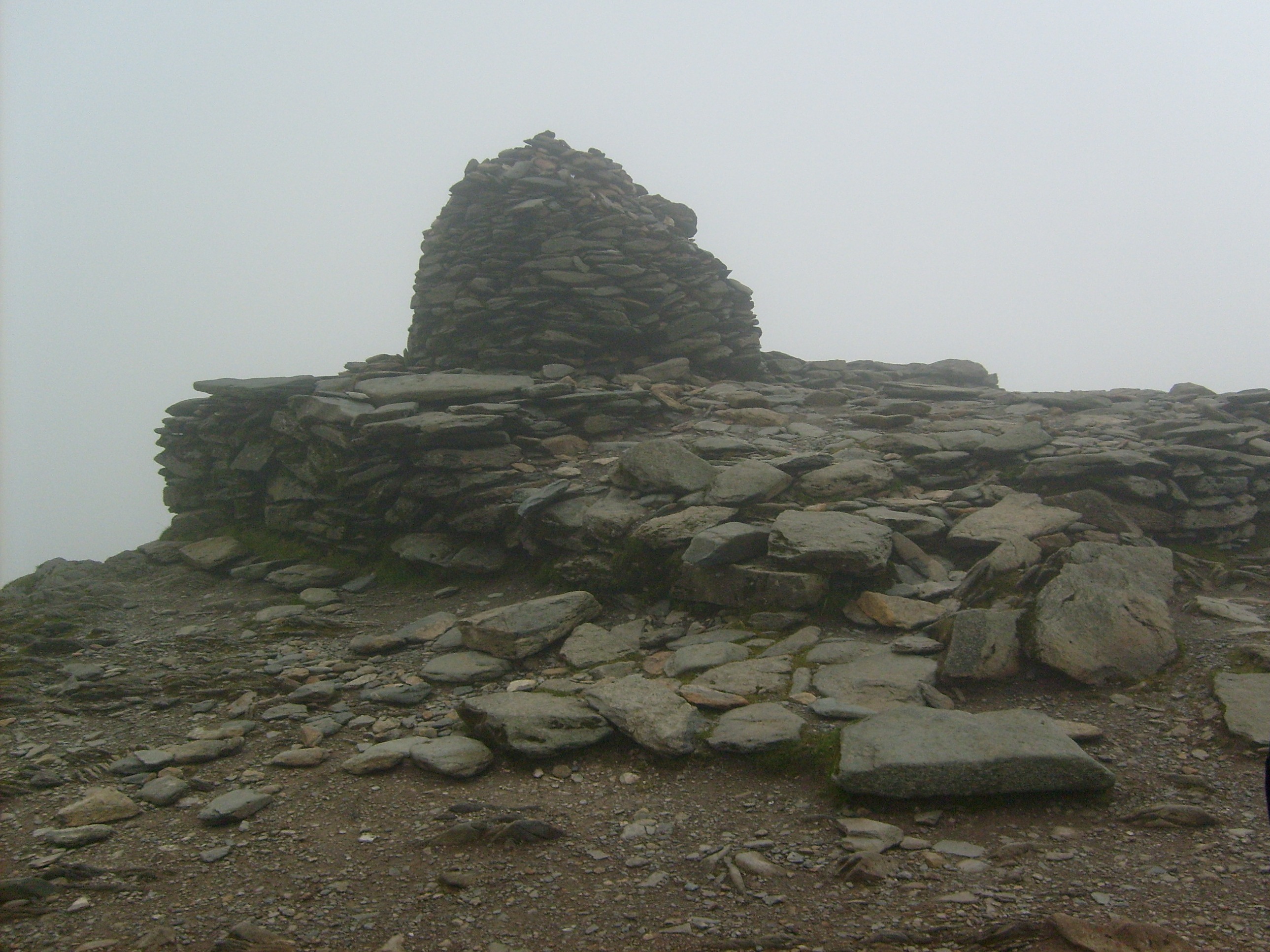
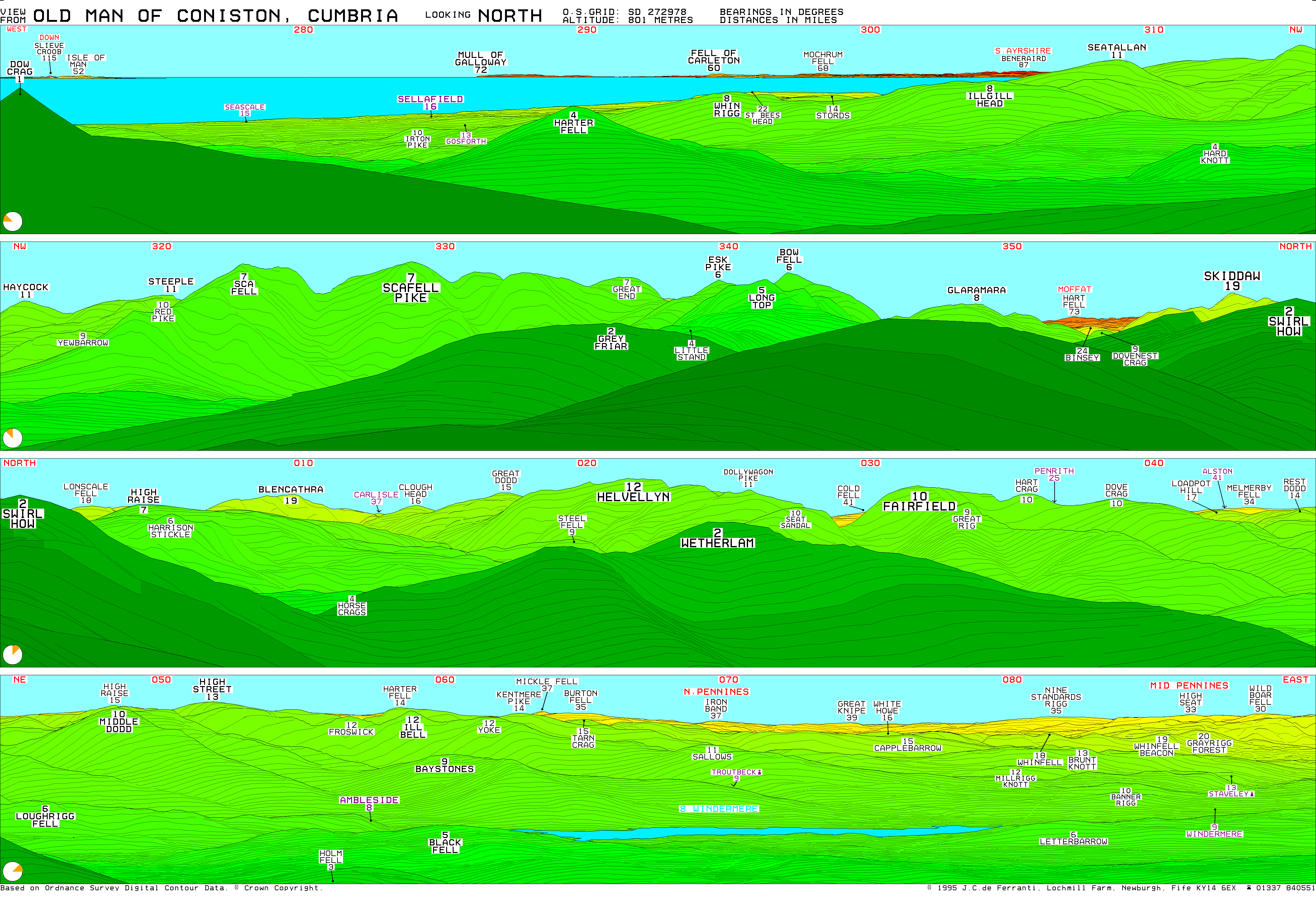
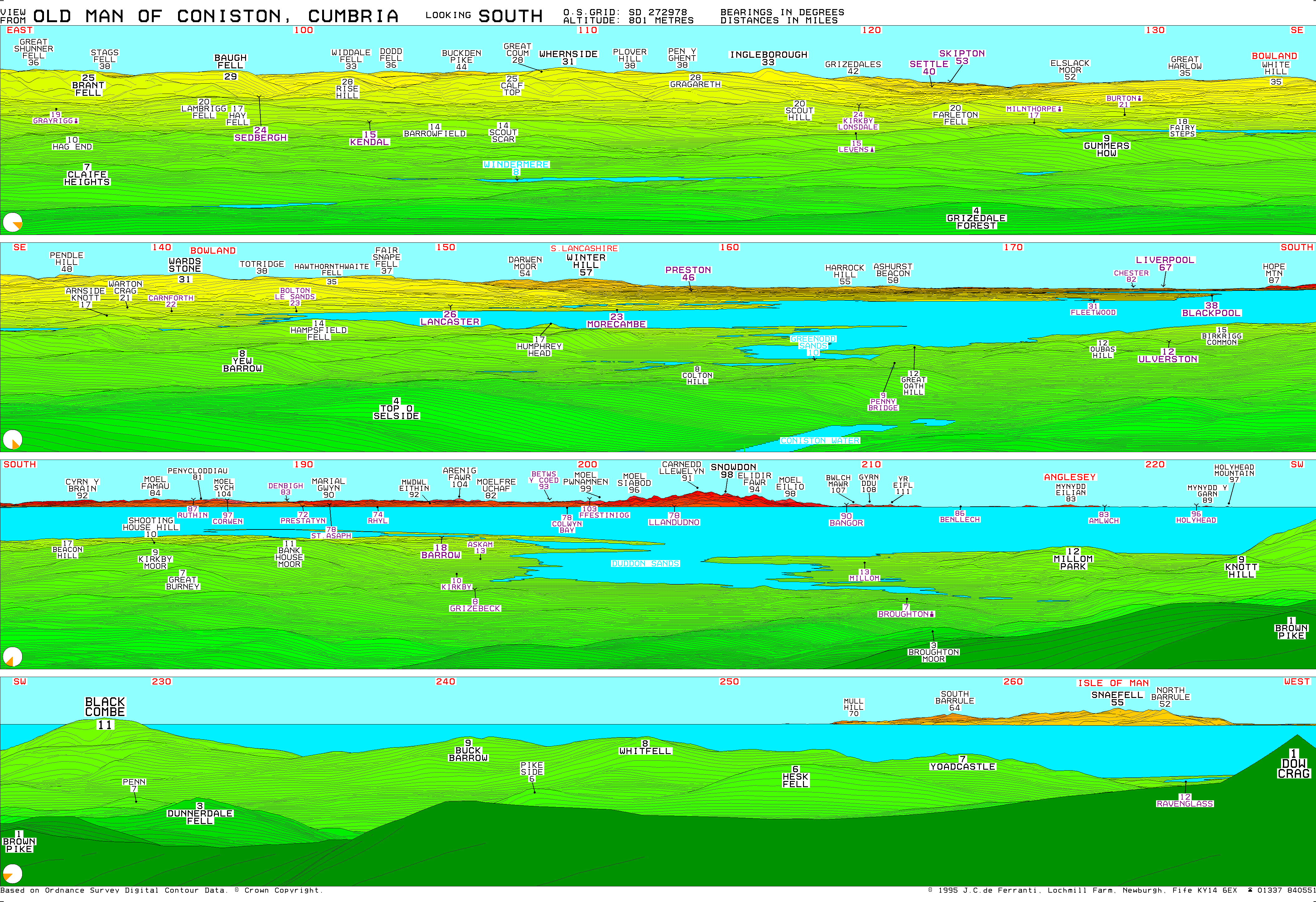
The summit of the fell carries a unique construction, a combined slate platform and cairn. The popularity of this climb has resulted in the resident sheep being quite tame, and they show no fear in rifling unwatched bags for food. The extensive view from the summit on a clear day includes much of the southern Lake District, Morecambe Bay, Blackpool Tower, Winter Hill, the Lancashire coast and the Isle of Man. Perhaps the highlight is the close up view of Dow Crag.[3][8]
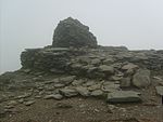 Cloud shrouded summit of Old Man of Coniston
Ascents
The fell is normally climbed from Coniston village via Church Beck and the mines (the tourist route). Alternatives include the south ridge and the path to Goat’s Water, both ascending from the Walna Scar Road. The carpark at the top of the metalled section provides a headstart for these routes. The Walna Scar Road can also be reached from Torver, or from Seathwaite in the Duddon Valley, although the latter results in an indirect climb via Dow Crag.
In 2006, London writer Kris Griffiths' attempt to climb The Old Man of Coniston for the first time almost ended fatally after getting trapped in the dark on his descent [9]
Slate & Copper Mining
Coniston has been Lakeland's centre for slate and copper mining for 500 years. The well known ‘Coniston copper mines’ are reputed to be some of the largest copper mines in Britain, with a vertical distance of around 2,000 ft (610 m).
The nearby slate mines on the North East flank of the Old Man, are known as "Old Man Quarries", though sometimes given the individual names of: Brandy Crag, SaddleStone and Moss Head. These slate mines have been worked since at least the 13th century. All the workings are more or less underground, apart from Low Brandy Crag, which was opened out into an opencast quarry in the 1980s by Burlington Stone, and is still operating today. Most of the lower levels in Saddlestone are blocked, though the Moss Head Quarries are still open.[1]
Geology
A band of the dacitic lapilli-tuffs of the Lag Bank Formation crosses the summit. The southern slopes show the volcaniclastic sandstones of the Seathwaite Fell Formation, while the rhyolitic tuffs of the Paddy End Member stretch from north of the summit toward the Coppermines.[10]
Influence
The Old Man of Coniston is the inspiration for Kanchenjunga, the mountain Arthur Ransome's Swallows and Amazons climb in the Swallows and Amazons novel Swallowdale.
References
- ^ a b Coniston Local History Group website
- ^ http://www.peakbagging.com/Peak%20Lists/Eng50.html
- ^ a b c d Richards, Mark: Southern Fells: Collins (2003): ISBN 0-00-711367-6
- ^ Birkett, Bill: Complete Lakeland Fells: Collins Willow (1994): ISBN 0-0021-8406-0
- ^ a b Blair, Don: Exploring Lakeland Tarns: Lakeland Manor Press (2003): ISBN 0-9543-9041-5
- ^ "Rights of Way Orders by Lake District National Park Authority 2009". http://www.planning-inspectorate.gov.uk/pins/row_order_advertising/councils/2009/lake_district_national_park_authority.htm. Retrieved 2009-12-31.
- ^ Adams, John: Mines of the Lake District Fells: Dalesman (1995) ISBN 0-85206-931-6
- ^ Alfred Wainwright: A Pictorial Guide to the Lakeland Fells, Book 4: ISBN 0-7112-2457-9
- ^ http://www.internationallife.tv/Hitting-Rock-Bottom
- ^ British Geological Survey: 1:50,000 series maps, England & Wales Sheet 38: BGS (1998)
External links
- Computer generated summit panoramas North South Index
- Lake District Walks - Old Man Of Coniston Walk
Wainwright's Southern Fells Allen Crags · Black Fell · Bowfell · Brim Fell · Cold Pike · Coniston Old Man (Old Man of Coniston) · Crinkle Crags · Dow Crag · Esk Pike · Glaramara · Great Carrs · Great End · Green Crag · Grey Friar · Hard Knott · Harter Fell (Eskdale) · Holme Fell · Illgill Head · Lingmell · Lingmoor Fell · Pike O'Blisco (Pike of Blisco) · Rossett Pike · Rosthwaite Fell · Scafell · Scafell Pike · Seathwaite Fell · Slight Side · Swirl How · Wetherlam · Whin RiggFull list of Wainwrights by area Categories:- Wainwrights
- Marilyns of England
- Hewitts of England
- Fells of the Lake District
- Nuttalls
- Furness

Wikimedia Foundation. 2010.