- Melbourne City Centre
-
This article is about the locality within the postcodes 3000, 3004 and 3006 of Melbourne in Victoria, Australia, officially known as "Melbourne". For the Greater Melbourne metropolitan area, see Melbourne. For the local government area that envelopes the locality, as well as some inner suburbs, see City of Melbourne.
City Centre
Melbourne, Victoria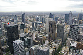
Aerial view of the Hoddle Grid in MelbournePopulation: 20,360 (suburb)[1] Established: 1835 Postcode: 3000, 3004, 3006 Location: - 35 km (22 mi) from Belgrave
- 29 km (18 mi) from Dandenong
- 19 km (12 mi) from Glen Waverley
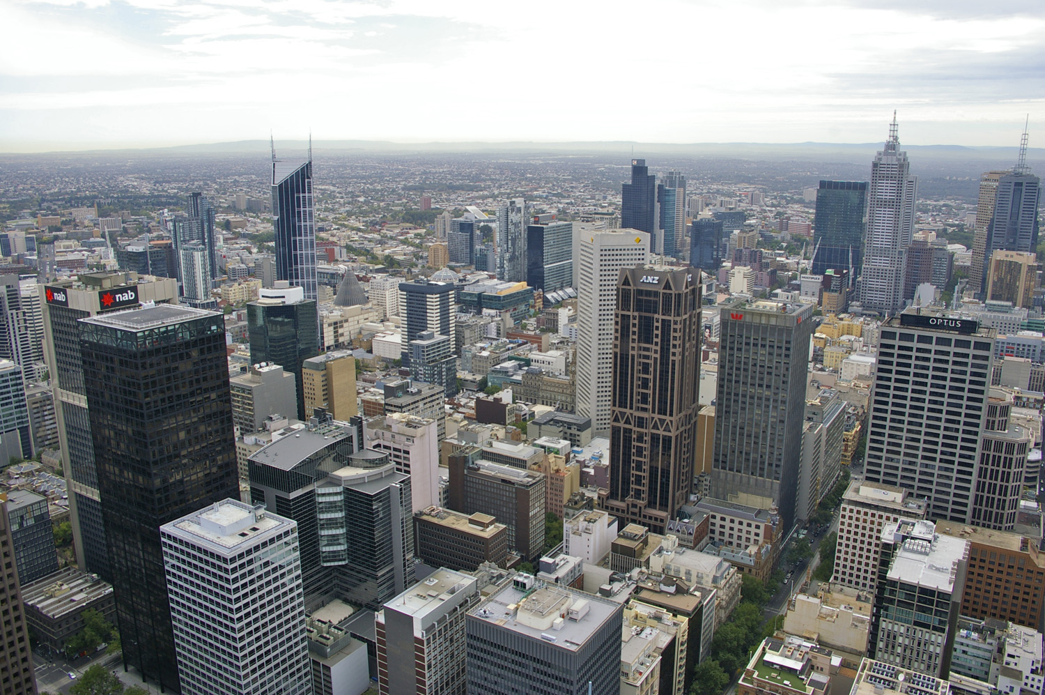
LGA: Melbourne State District: Melbourne Federal Division: Melbourne Localities around City Centre: North Melbourne Carlton / Parkville Fitzroy Docklands City Centre East Melbourne Port Melbourne Southbank / South Wharf St Kilda Rd / South Yarra Melbourne City Centre (sometimes referred to as "Central City",[2] and colloquially known as simply "The City") is an area of Melbourne in Victoria, Australia. It is not to be confused with the larger local government area of the City of Melbourne. It is the area in which Melbourne was established in 1835,[3] and its boundaries are defined by the Government of Victoria's Melbourne Planning Scheme.[4] Today, it comprises the two oldest areas of Melbourne; the Hoddle Grid and Queen Victoria Market, as well as sections of the redeveloped areas of Southbank and South Wharf.[5]
It is the core of the central activities district (CAD) of Melbourne's inner suburbs, and encompasses a number of places of significance, which include: Crown Casino, Federation Square, Flinders Street Station, Melbourne Aquarium, Melbourne Convention and Exhibition Centre, Melbourne Town Hall, National Gallery of Victoria, State Arts Centre of Victoria, State Library of Victoria, State Parliament of Victoria, Supreme Court of Victoria and the Australian Centre for the Moving Image. Bordering its north-east perimeter is the World Heritage-listed Royal Exhibition Building and Carlton Gardens as well as the Melbourne Museum. It is also the main terminus for the Melbourne metropolitan and Victorian regional passenger rail networks - being Flinders Street and Southern Cross stations respectively, as well as the most dense section of the Melbourne tram network.
It is the major central business district (CBD) of Greater Melbourne's metropolitan area, and a major financial centre in Australia and the Asia-Pacific region.[6] The City is home to the corporate headquarters of the World's two largest mining companies: BHP Billiton and Rio Tinto Group; as well as two of Australia's "big four" banks: ANZ and NAB, two largest gaming companies: Crown and Tabcorp, largest telecommunications company Telstra, two largest transport management companies: Toll and Transurban as well as the iconic brewing company Foster's Group. It also serves as the main administrative centre for the City of Melbourne and the Government of Victoria – the latter with the suburb of East Melbourne. Two universities have major campuses in the area: Royal Melbourne Institute of Technology (RMIT City campus) and University of Melbourne (Victorian College of the Arts).
It has hosted a number of events of significance, which include: the 1901 inauguration of the Government of Australia, 1956 Summer Olympic Games, 1981 Commonwealth Heads of Government Meeting, 1995 World Police and Fire Games, 2000 World Economic Forum, 2006 Commonwealth Games and G20 Ministerial Meeting. It is also recognised for the substantial number of cultural and sports events and festivals it holds annually – many being the largest in Australia and the World. The Hoddle Grid is home to Melbourne's famed alleyways and arcades and is renowned for its distinct blend of contemporary and Victorian architecture as well as expansive parks and gardens which adjoin it edges.[7] It is also the literary centre of Australia, and has more bookshops and publishing companies per capita than any other city in Australia, and includes the headquarters of the World's largest travel guidebook publisher Lonely Planet. In 2008, it was designated a "City of Literature" by UNESCO in its Creative Cities Network.[8]
Contents
History
Further information: History of MelbourneMelbourne's central grid patterned layout, known as the Hoddle grid, was first laid out in 1837. From the 1870s to 1920s, the central part of Melbourne was home to mostly medical professionals who had established practices along Collins Street and Spring Street[9] and before the 1960s, only a handful of permanent residents lived in the Spring Street area and St Kilda Road. The area was largely unpopular for residents and council policies did not permit development of apartment style housing in the area.
St Kilda Road was annexed in the 1960s and given the postcode of Melbourne 3004 to stimulate office development along the strip and reduce pressure on overdevelopment of the Hoddle Grid. The result was the demolition of many of the street's grand mansions.
Things changed somewhat due to the Kennett government's Postcode 3000 planning policy in the 1990s, which provided incentives for living in the central area.
Although the city centre now includes St Kilda Road, it competes for office space with Southbank, Docklands and the major outer suburban centres such as Box Hill, Glen Waverley, Ringwood, Belgrave, Ferntree Gully and increasingly South Yarra.
Boundaries and geography
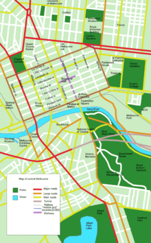 Map of Melbourne City Centre (with some inner suburbs)
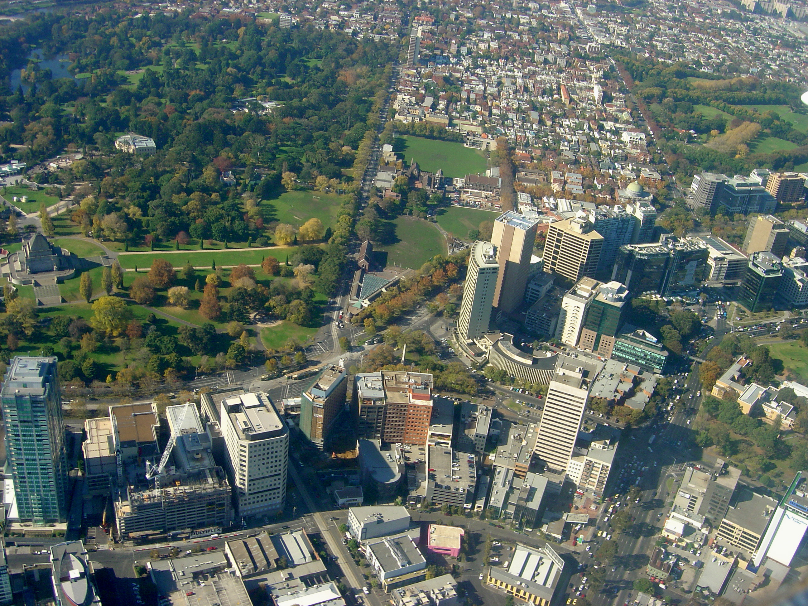
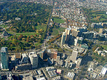 An aerial view of part of the St Kilda Road office district and the Botanic Gardens area.
Officially, the city centre is bordered by Spencer Street to the west and extends north as far as Grattan Street which borders Carlton. The border extends along La Trobe Street, William Street, Peel Street, Grattan Street, taking in the Queen Victoria Market, Berkeley Street, Victoria Street. To the east it is bordered by Spring Street, however the area extends east to take in parts of Wellington Parade, Brunton Avenue, Punt Road and the Yarra River. It borders South Yarra to the south east at Anderson Street, Domain Road, Domain Street, Arnold Street, Fawkner Park, Commercial Road, High Street. It also borders both St Kilda along St Kilda Road and Albert Park along Queens Road, Lakeside Drive and South Melbourne along Albert Road, Kings Way, Palmerston Crescent, Wells Place and finally Southbank along St Kilda Road and the south side of Flinders Street (Northbank) which includes Flinders Street Station and the Melbourne Aquarium.
Although these are the borders on official maps, there are several adjoining areas that function as part of the Central Activities District. This includes Melbourne Docklands (with Docklands Stadium), Southbank, Victoria and East Melbourne/Jolimont (with the Melbourne Cricket Ground).
Although the area is described as the centre, it is neither the geographic or demographic centre of Melbourne, due to an urban sprawl to the south east; the geographic centre is currently located at Bourne St, Glen Iris.[10]
Demographics
Central Melbourne has one of the fastest growing residential populations in Australia. Residents of the city centre are of mixed social status.[11] On one hand, living in the centre of the city offers proximity to work and the best access to public transport. On the other hand, there are many strata titled studio apartments that have no carparks and limited space. As a result there is a mix of students and young urban professionals living in the locality of Melbourne.
Economy
Jetstar Airways has its head office in the suburb.[12][13]
Culture and sport
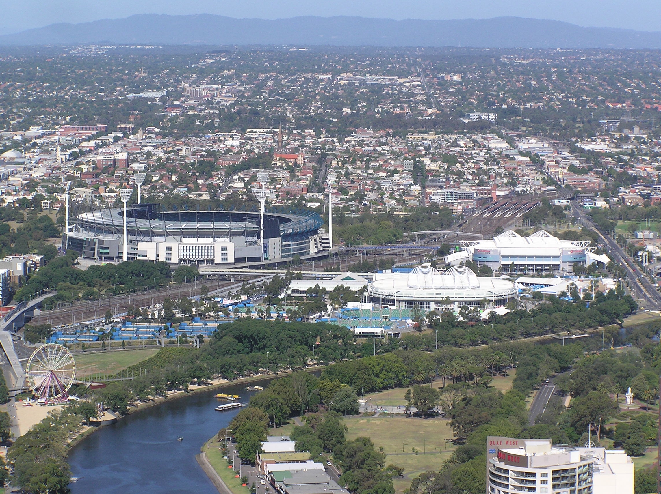
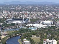 3 major buildings of Melbourne Park: 1. Melbourne Cricket Ground (MCG) 2. Rod Laver Arena (Australian tennis stadium) 3. Vodafone Arena (sports & entertainment venue)
Most professional sporting clubs represent Greater Melbourne (e.g. Melbourne Victory, Melbourne Storm). An exception is the Melbourne Cricket Club and Melbourne Football Club (its offshoot) both based at the Melbourne Cricket Ground which was built in Jolimont, adjacent to the city but a locality of the suburb of East Melbourne. Both were the first clubs of their respective sports and established in a time when the city's population was still very small and limited to a handful of inner suburbs. As a result, the Melbourne Cricket Club has a fairly exclusive membership, whilst the Melbourne Football Club, although bearing the name Melbourne, is associated by the supporters of other suburban clubs as representing the central suburb and perceive its supporters to represent the locality and not the entire city.[14] As a result, despite its rich tradition and early success, it is one of the least supported clubs in the VFL/AFL. The lack of identity resulted in a push for the Melbourne Hawks, which was stopped by intervention from Joseph Gutnick and the majority of the Hawthorn Football Club members. It has had intense rivalries with younger clubs from the adjacent inner suburbs such as the Collingwood Football Club and early inter-town rival Geelong Football Club. The Melbourne Football Club has recently made efforts to shed its suburban tag and be embraced by the whole metropolitan area.[15] In line with this, the club recently employed strategies such as establishing Team Melbourne, (a group of sporting teams which bear the name "Melbourne"), and a strategy for promoting the brand as representing the city in China through club supporter and former Lord Mayor John So.
Golf is played at the course of the Albert Park Golf Club on Queens Road.[16]
Transport
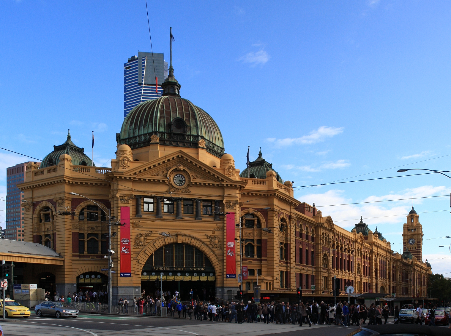
 Flinders Street Station
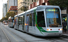 Trams on Spencer Street
The Melbourne City Centre is the transport hub of the city.
Despite a wide range of public transport options, the automobile still remains the primary method of getting around in the Melbourne City Centre. The main arterial is King Street. There are major taxi termini in the CBD.
The city is serviced by five railway stations as part of the Melbourne Underground Rail Loop: Flinders Street (the busiest), Southern Cross Station (the hub of the regional network in Spencer Street at Melbourne Docklands) also an interstate terminal and three underground stations - Parliament, Melbourne Central and Flagstaff (not open on weekends) stations. Flinders Street Station is also the hub for Melbourne's suburban train network.
Trams run down the main streets Flinders, Collins, Bourke and Latrobe as well as Spencer Street, Market Street, Elizabeth Street, Swanston Street, Spring Street, Swan Street and St Kilda Road. There are several large accessibility tram superstops located in Flinders Street, Collins Street, Swanston Street and Bourke Street mall.
The city is also well connected by bus services, with majority of buses running down Lonsdale street. Major bus stops include Melbourne Central and QV. Most bus routes service suburbs north and east of the city given the lack of train lines to these areas.
Major bicycle trails lead to the CBD and a main bicycle path down Swanston Street.
Ferries dock along the northbank of the Yarra at Federation Wharf and the turning basin at the Aquatic Centre. There is also a water taxi service to Melbourne and Olympic Parks.
References
Notes:
- ^ Australian Bureau of Statistics (25 October 2007). "Melbourne (Urban Centre/Locality)". 2006 Census QuickStats. http://www.censusdata.abs.gov.au/ABSNavigation/prenav/LocationSearch?collection=Census&period=2006&areacode=SSC21439&producttype=QuickStats&breadcrumb=PL&action=401. Retrieved 2007-10-25.
- ^ Government of Victoria 2009, p. 1, clause 21.08-1
- ^ Melbourne City Council 1997, p. 8
- ^ Government of Victoria 2009, p. 3, figure 12: Central City
- ^ Government of Victoria 2009, p. 3, figure 12: Central City
- ^ Friedman, John (1997), "Cities Unbound: The Intercity Network in the Asia-Pacific Region", Management of Social Transformations, UNESCO, retrieved: 5 August 2011
- ^ Diamonstein, Barbaralee (9 August 1987), "Victorian Scenes on a Melbourne Walk", New York Times, The New York Times Company, retrieved: 5 August 2011
- ^ "Melbourne, Australia: City of Literature", Creative Cities Network, UNESCO, retrieved: 10 August 2011
- ^ Collins Street from the City of Melbourne
- ^ Glen Iris still the heart of city's sprawl, The Age, 5 August 2002
- ^ City of Melbourne - Research - Who lives in the city?
- ^ "Corporate addresses". Jetstar Airways. http://www.jetstar.com/au/en/contact-us/corporate-addresses.aspx. Retrieved 12 August 2009.
- ^ "Terms of use." Jetstar. Retrieved on 25 December 2010. "Licensed Address: 473 Bourke St, MELBOURNE, VIC, 3000"
- ^ Melbourne Demons - The rust bucket of Australia from ConvictCreations.com
- ^ A new base for Demons? from the Age
- ^ Golf Select, Albert Park, http://www.golfselect.com.au/armchair/courseView.aspx?course_id=255, retrieved 2009-05-11
Texts:
- Government of Victoria (2009), Melbourne Planning Scheme, Department of Planning and Community Development (PDF version), retrieved: 5 August 2011
- Melbourne City Council (1997), The History of the City of Melbourne, Melbourne City Records and Archives Branch (PDF version), retrieved: 5 August 2011
External links
- Local history of Melbourne CBD
- Melbourne City Centre is at coordinates 37°49′05″S 144°58′34″E / 37.818°S 144.976°ECoordinates: 37°49′05″S 144°58′34″E / 37.818°S 144.976°E
Events in the Melbourne City Centre Note: this includes events held in the Melbourne City Centre and its fringe areas, not the Greater Melbourne metropolitan area Summer All: Summer Fun in the City of Melbourne
December: Australian Dancesport Championships • Australian Film Institute Awards • Boxing Day Test • Carols by Candlelight • Myer Christmas Parade
January: Australian Open • Midsumma Festival • Melbourne International Boat Show • One Day International Cricket
February: Melbourne International Motor Show • St Kilda FestivalAutumn March: Australian Grand Prix • Melbourne Fashion Festival • Melbourne Food and Wine Festival • Moomba Waterfest • Melbourne Queer Film Festival
April: ANZAC Day Parade • AFL ANZAC Day clash • Logie Awards • Melbourne International Comedy Festival • Melbourne International Flower and Garden Show • Melbourne Jazz Festival
May: Human Rights Arts and Film Festival • Melbourne Jazz Fringe FestivalWinter All: Melbourne Winter Masterpieces series
June: AFL Queen's Birthday clash • Melbourne International Animation Festival
July: State of Design Festival • Melbourne International Film Festival • Melbourne Open House • Run Melbourne
August: Melbourne Day • Melbourne Underground Film Festival • Melbourne Writers Festival • Manifest • Craft CubedSpring September: AFL Grand Final • Melbourne Fringe Festival • Melbourne International Festival of Brass • Royal Melbourne Show • Melbourne Spring Fashion Week
October: Around the Bay in a Day • Melbourne International Arts Festival • Melbourne Marathon Festival • Melbourne Spring Racing Carnival
November: Head of the Yarra • Melbourne Cup CarnivalSee also: Landmarks in the Melbourne City Centre · Museums in the Melbourne City Centre · Theatres in the Melbourne City Centre Theatres in the Melbourne City Centre Note: this includes theatres in the Melbourne City Centre and its fringe areas, not the Greater Melbourne metropolitan area Venues ACCA • Arts Centre • Comedy Theatre • Forum Theatre • Her Majesty's Theatre • La Mama Theatre • Malthouse Theatre • Melbourne Athenaeum • Melbourne Recital Centre • MTC Theatre • National Theatre • Palais Theatre • Palace Theatre • Princess Theatre • Regent Theatre • RMIT Capitol Theatre • Sidney Myer Music BowlMajor Companies The Australian Ballet • OXYGEN Productions • Chunky Move • Melbourne Symphony Orchestra • Melbourne Theatre Company • Opera Australia • Victorian OperaSee also: Events in the Melbourne City Centre • Landmarks in the Melbourne City Centre • Museums in the Melbourne City Centre Museums in the Melbourne City Centre Note: this includes museums in the Melbourne City Centre and its fringe areas, not the Greater Melbourne metropolitan area Chinese Museum · City Museum · Cooks' Cottage · Heide Museum of Modern Art · Hellenic Museum · Ian Potter Museum of Art · Immigration Museum · Jewish Museum · La Trobe's Cottage · Maritime Museum · Melbourne Museum · Sports Museum · Scienceworks MuseumSee also: Events in the Melbourne City Centre · Landmarks in the Melbourne City Centre · Theatres in the Melbourne City Centre Streets of Melbourne's Hoddle Grid Latitudinal streets Longitudinal streets South to North: Flinders · Flinders Lane · Collins · Little Collins · Bourke · Little Bourke · Lonsdale · Little Lonsdale · La TrobeSignificant lanes ACDC Lane · Bank Place · Bligh Place · Block Place · Caledonian Lane · Causeway Lane · Centre Place · Degraves Street · Hardware Lane · Hosier Lane · Niagara Lane · Manchester Lane · McKillop Street · Punch LaneSignificant arcades Block Arcade · Campbell Arcade · Cathedral Arcade · Centreway Arcade · Howey Place · Melbourne GPO · Port Philip Arcade · Royal ArcadeMelbourne's public transport - Metlink Modes and network Ticketing Metropolitan rail operators Metro Trains Melbourne (heavy rail) • KDR Melbourne - Yarra Trams (tram/light rail)Regional rail operators V/Line (heavy rail)Metropolitan and regional bus operators Broadmeadows Bus Service • Cardinia Transit • Cranbourne Transit • Driver Bus Lines • Dyson's Bus Services • Eastrans • East West Bus Company • Grenda's • Hope Street Bus Line • Invicta Bus Services • Ivanhoe Bus Company • Kastoria Bus Lines • Martyrs Bus Service • Melbourne Bus Link • McKenzie's • Moonee Valley • Moorabbin Transit • Moreland Buslines • NationalBus • Panorama Coaches • Peninsula Bus Lines • Portsea • Reservoir • Ryan Brothers Bus Service • Sita Buslines • Skybus Super Shuttle • Sunbury Bus Service • Tullamarine Bus Lines • US Bus Lines • Ventura Bus Lines • WestransPlanned infrastructure Melbourne Metro • Regional Rail Link • Proposed Rail ExtensionsAuthorities Trams in Melbourne - Yarra Trams Routes Current Tram Fleet W • Z • A • B • C • C2 • DOperator KDR Melbourne (Yarra Trams)Former operators Prahran and Malvern • Hawthorn • Melbourne, Brunswick and Coburg • Fitzroy, Northcote and Preston • Footscray • Northcote Municipality • North Melbourne Electric Tramway and Lighting Company • Melbourne and Metropolitan Tramways Board • Victorian Railways • M>Tram • Transdev TSLTourist services Tram depots Brunswick • Camberwell • East Preston • Essendon • Glenhuntly • Hawthorn • Kew • Malvern • North Fitzroy • Preston Workshops • Newport Workshops • Southbank • South MelbourneMiscellaneous Suburbs of the City of Melbourne | Melbourne | Victoria Carlton · Carlton North · Docklands · East Melbourne · Flemington · Kensington · Melbourne CBD · North Melbourne · Port Melbourne · Parkville · Southbank · South Wharf · South Yarra · West Melbourne
Suburbs of the City of Port Phillip | Melbourne | Victoria Albert Park · Balaclava · Elwood · Melbourne · Middle Park · Port Melbourne · Ripponlea · St Kilda · St Kilda East · St Kilda West · Southbank · South Melbourne
Categories:- Landmarks in Melbourne
- Festivals in Melbourne
- Geography of Melbourne
- Central business districts in Australia


Wikimedia Foundation. 2010.