- Melbourne tram route 86
-
Bundoora RMIT - Waterfront City Docklands 
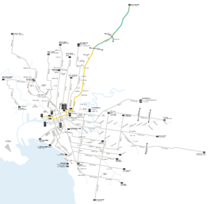
Route Information Route Number 86 Number of stops 75 in / 74 out Timetables Link Route Map Link Zone Location Zone 1 Docklands Drive (Waterfront City) - Plenty Road (Tyler Street) Zone 1 & 2 Plenty Rd (Tyler Street - Bundoora RMIT) Tram route 86 is a public transport service in Melbourne, Victoria, Australia. It runs from Bundoora in the northern suburbs to Waterfront City Docklands in the city. It is one of Melbourne's busiest tram routes carrying 44,200 passengers a day.[1] Route 86 will be one of two suburban tram routes to provide a transport link to The Southern Star observation wheel.
Unlike most tram routes in Melbourne, it falls within Metcard/myki ticketing Zone 1 and Zone 1/2.
An extension from Docklands along Footscray Road to Footscray is proposed.[2]
In 2010 Melbourne-based musical comedian The Bedroom Philosopher released an album Songs from the 86 Tram inspired by the tram route as well as an award-winning comedy show of the same name.[3]
Contents
History
A cable tram line operated by the Melbourne Tramway and Omnibus Company opened on 10 August 1887, operating along Bourke Street, Gurtrude Street, Smith Street and Queens Parade to the Merri Creek.[4] On 18 February 1890 a group of Northcote land speculators built a line between the Melbourne Tramway and Omnibus Company terminus and Dundas Street, the line was not as successful as they had hoped, closed down and reopened twice before the municipal government bought it in 1901 and leased out its operation. At the end of the lease council took over operation for a short time.[5] The Melbourne Tramway and Omnibus Company line was taken over by the Melbourne and Metropolitan Tramways Board on 1 November 1919 with the Northcote Cable Tramway line coming under Melbourne and Metropolitan Tramways Board control on 20 February 1920.[5]
The Fitzroy, Northcote and Preston Tramways Trust had started constructing a system but it wasn't until after its takeover by the Melbourne and Metropolitan Tramways Board that services first ran, on 1 April 1920, part of this system included a line from Dundas Street to Tyler Street.[6] This network was orphaned from the rest of the electric network until 24 March 1925 when a line along Holden Street, Pilkington Street and Barkly Street was built by the Melbourne and Metropolitan Tramways Board to allow access to the CBD via Lygon Street.[7]
The two cable lines were through routed by the Melbourne and Metropolitan Tramways Board, and operated until 26 October 1940, when the Bourke Street cable lines were abandoned by the Melbourne and Metropolitan Tramways Board in favour of double decker buses.[8] The Bourke Street cable lines were the last cable trams to operate in Melbourne. Melbourne and Metropolitan Tramways Board, unhappy with the performance of the buses wished to rebuilt the lines as electric tram services, it was decided to reinstate trams when the buses were life expired, trams first ran on the 88 (predecessor to the modern 86) on 26 June 1955,[9] with East Brunswick starting operating on 6 May 1956.[9]
On 18 May 1983 the suburban terminus was extended from Tyler Street to Boldrewood Parade, then to La Trobe University on 10 January 1985, to Settlement Road on 26 April 1987[10] and to the current terminus at McKimmies Road on 12 October 1995.[11] This final extension cost $12.6 million and was funded as part of the Commonwealth Government's Building Better Cities program.[12]
As part of the Docklands redevelopment project La Trobe Street was extended west over the Spencer Street railyards in 2000,[13] and with this extension route 86 was extended along Spencer Street and La Trobe Street to Docklands Stadium.
In July 2008 route 30 and route 86 swapped terminus's, with route 30 terminating in Harbour Esplanade at Central Pier, and route 86 being extended to Waterfront City.[14]
In August 2008 route 86 was the first route to see tram based testing of the myki ticketing system, using special services not open to normal fare-paying passengers.[15]
Prior the all trams stops in Zone 2 being rezoned as Zone 1/2 overlap - as a result of the introduction of myki - stops 61 to 71 were in Zone 2.
A project to: improve access through platform stops, perform track and overhead renewal and improve speed and reliability on a 6.8km section of route 86, along High Street and Plenty Road, between Westgarth Street, Westgarth and Albert Street, Reservoir was started in 2011.[16][17]
Route
Route 86 

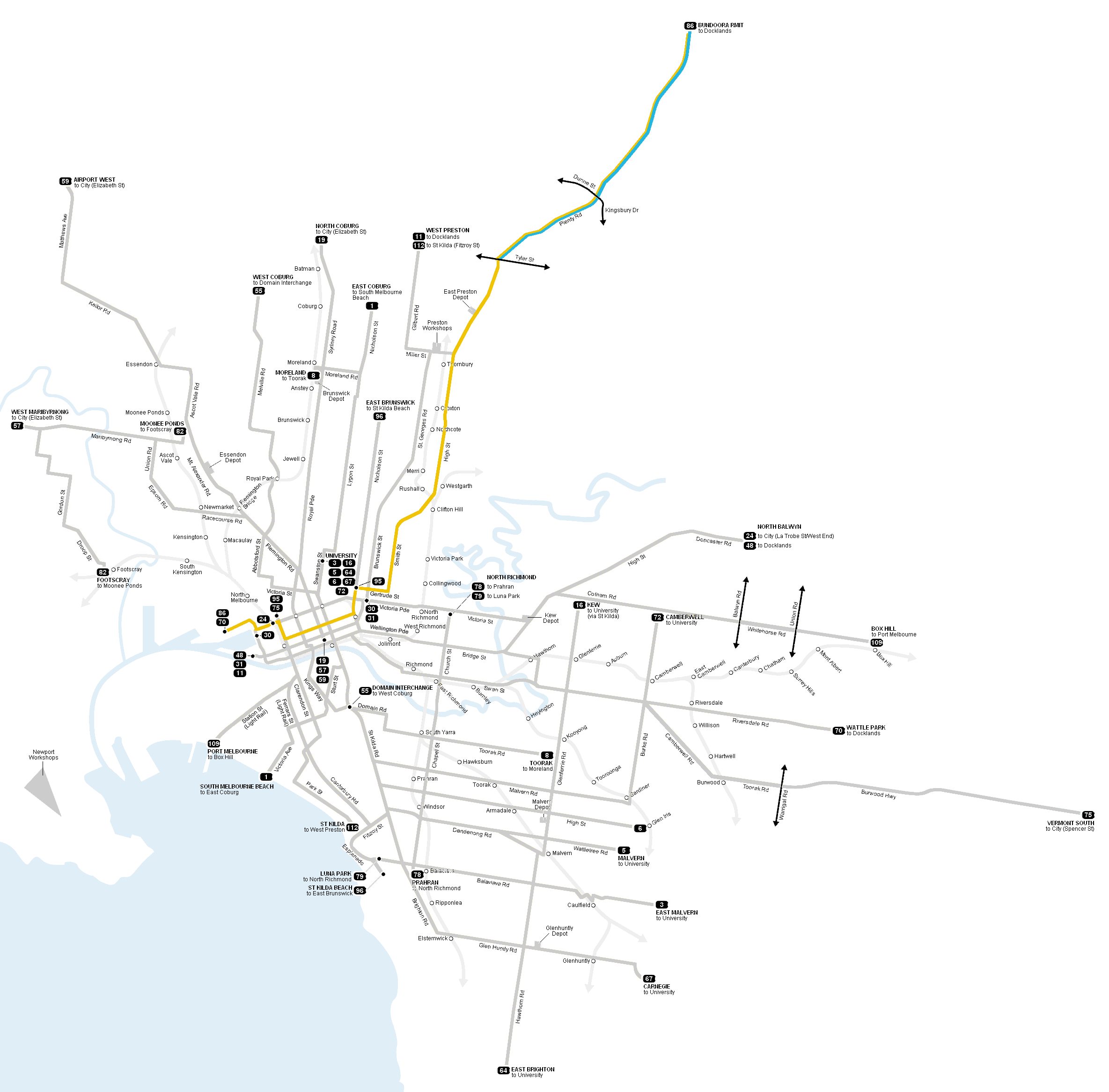
Bundoora RMIT Stop 71 
Clements Rd 70 Grimshaw St 65 La Trobe University 60 Reservoir District Secondary College 57 
Tyler St 52 
Murray Rd 49 
Preston Bell St Bell Station 45 Dundas St 42 Separation St Northcote Station 33 Northcote Westgarth St Westgarth Station 27 Clifton Hill Clifton Hill Station 25 Fitzroy Johnston St 19 Gertrude St 15 Brunswick St Route 112 13 Melbourne Museum Route 96 12 Victoria Pde Routes 24, 30, City Circle 11 City Spring St Parliament Station 9 Swanston St Routes 1, 3/3a, 5, 6, 8, 16, 64, 67, 72 6 Elizabeth St Routes 19, 57, 59 5 Queen St 4 William St Route 55 3 Spencer St Southern Cross Station Routes 75, 96 1 Etihad Stadium D1 
Waterfront City Docklands D11 Not all stops are shown, refer to timetable for full list of stops.
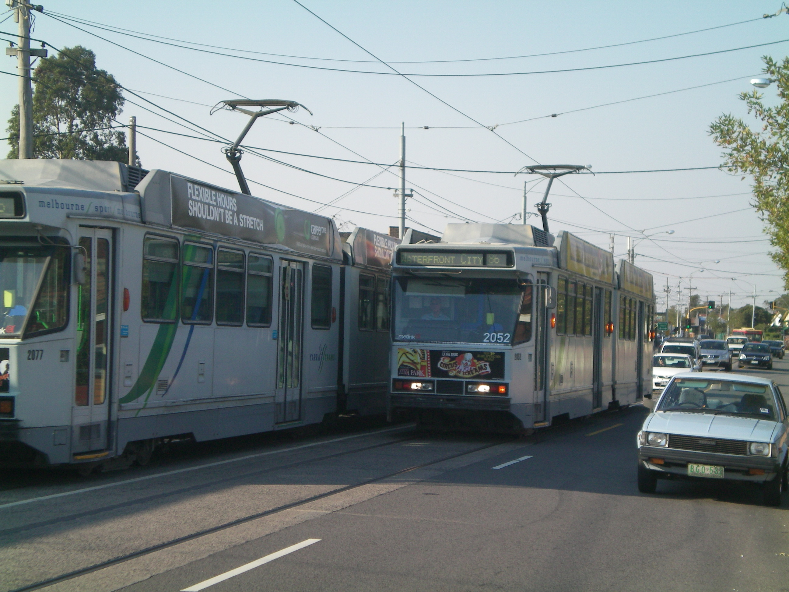
 Two route 86 trams pass each other along Plenty Road, Preston
Route 86 runs from Bundoora, travelling south on Plenty Road traversing the suburbs of, Reservoir and Preston, passing RMIT Bundoora Campus and La Trobe University. Plenty Road ends in Preston at Dundas Street and High Street, route 86 turns slightly into High Street and continues south through Thornbury and Northcote. It then crosses the Merri Creek, continuing along Queens Parade Clifton Hill, heading south west, turning south into Smith Street passing between Fitzroy and Collingwood. Just before the end of Smith Street it turns west into Gurtrude Street, Fitzroy, and south into Nicholson Street, Carlton, past the Royal Exhibition Building in the Carlton Gardens, a World Heritage Site.
It enters the CBD on Spring Street turning west into Bourke Street at Parliament House, travels through the Bourke Street Mall and turns north into Spencer Street, passing Southern Cross Station, it turns west at La Trobe Street, passing over the Spencer Street rail yards into Docklands, it travels north briefly on Harbour Esplanade before turning west into Docklands Drive, where it terminates in Waterfront City Docklands.
Operation
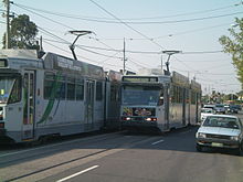
Route 86 is run from East Preston depot[18] and is predominantly run with B2 class trams and the two B1 class trams (they run out of East Preston depot), although it isn't uncommon for A class trams to be rostered on.
Maps and Timetables
- Official timetables
- Official route map
- Official tram network map
- Tram and train network map from railmaps.com.au
See also
- Trams in Melbourne
- Transportation in Australia
References
- ^ "Learning our lines", The Age, http://www.theage.com.au/victoria/learning-our-lines-20110618-1g94d.html, retrieved 2011-09-28
- ^ Lucas, Clay (2008-01-02). "Vision for 'friendlier' Docklands". The Age. http://www.theage.com.au/articles/2008/01/01/1198949817058.html?page=fullpage#contentSwap1. Retrieved 2008-07-19.
- ^ http://www.comedyfestival.com.au/2010/season/shows/the-bedroom-philosopher-songs-from-the-86-tram
- ^ "Melbourne Tramway and Omnibus Company Limited", TMSV Running Journal Vol 9 No 3, page 16, http://www.tramway.org.au/runningjournal/rj_vol9_no3.pdf, retrieved 2011-10-16
- ^ a b "Northcote: the on again, off again cable tramway", Friends of Hawthorn Tram Depot, http://www.hawthorntramdepot.org.au/papers/northcote.htm, retrieved 2011-10-03
- ^ "Milestones, 1911 - 1920", Yarra Trams, http://www.yarratrams.com.au/desktopdefault.aspx/tabid-155/173_read-883/, retrieved 2011-10-03
- ^ "Milestones, 1921 - 1930", Yarra Trams, http://www.yarratrams.com.au/desktopdefault.aspx/tabid-155/173_read-882/, retrieved 2011-10-09
- ^ "Milestones, 1931 - 1940", Yarra Trams, http://www.yarratrams.com.au/desktopdefault.aspx/tabid-155/173_read-881/, retrieved 2011-10-03
- ^ a b "Milestones, 1951 - 1960", Yarra Trams, http://www.yarratrams.com.au/desktopdefault.aspx/tabid-155/173_read-879, retrieved 2011-10-03
- ^ "Milestones, 1981 - 1990", Yarra Trams, http://www.yarratrams.com.au/desktopdefault.aspx/tabid-155/173_read-876/, retrieved 2011-10-03
- ^ "Milestones, 1991 - 2000", Yarra Trams, http://www.yarratrams.com.au/desktopdefault.aspx/tabid-155/173_read-875/, retrieved 2011-10-03
- ^ Lyndsay Neilson. "Appendix 1: Funding Allocation, Victorian Area Strategies". The ‘Building Better Cities’ program 1991-96: a nation-building initiative of the Commonwealth Government. epress.anu.edu.au. http://epress.anu.edu.au/anzsog/auc/mobile_devices/ch08s15.html#d0e3496. Retrieved 2010-11-01.
- ^ "Thank You Melbourne", VicUrban, http://www.docklands.com/cs/Satellite?c=VArticle&cid=1182927626861&pagename=VicUrban%2FLayout&site=Docklands&pid=1182927626296&oaid=1182927626797, retrieved 2011-10-04
- ^ "Completed tram initiatives", Department of Transport, http://www.transport.vic.gov.au/pt/public-transport-projects-and-improvements/metropolitan-tram-network/completed-tram-initiatives, retrieved 2011-10-03
- ^ Ashley Gardiner (August 18, 2008). "Smart card tests to begin on trams this week". Herald Sun. www.news.com.au. http://www.news.com.au/heraldsun/story/0,21985,24196543-2862,00.html. Retrieved 2008-08-18.
- ^ "Tram Route 86 Corridor Project", Darebin City Council, http://www.darebin.vic.gov.au/page/page.asp?page_Id=6152, retrieved 2011-10-04
- ^ "Tram Route 86 – High Street and Plenty Road", VicRoads, http://vicroads.vic.gov.au/Home/RoadProjects/MelbourneRoadProjects/Inner/TramRoute86.htm, retrieved 2011-10-04
- ^ "East Preston Depot", VICSIG, http://www.vicsig.net/index.php?page=trams&depot=east%20preston, retrieved 2011-10-04
Trams in Melbourne - Yarra Trams Routes Current Tram Fleet W • Z • A • B • C • C2 • DOperator KDR Melbourne (Yarra Trams)Former operators Prahran and Malvern • Hawthorn • Melbourne, Brunswick and Coburg • Fitzroy, Northcote and Preston • Footscray • Northcote Municipality • North Melbourne Electric Tramway and Lighting Company • Melbourne and Metropolitan Tramways Board • Victorian Railways • M>Tram • Transdev TSLTourist services Tram depots Brunswick • Camberwell • East Preston • Essendon • Glenhuntly • Hawthorn • Kew • Malvern • North Fitzroy • Preston Workshops • Newport Workshops • Southbank • South MelbourneMiscellaneous Categories:- Tram routes in Melbourne
Wikimedia Foundation. 2010.