- Kensington, Victoria
Infobox Australian Place | type = suburb
name = Kensington
city = Melbourne
state = vic

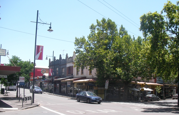
caption = The corner of Bellair St and Macaulay Rd is the commercial heart of Kensington and opposite the main railway station.
lga = City of Melbourne
lga2 = City of Moonee Valley
postcode = 3031
pop = 8676 (2006) Census 2006 AUS | id = SSC21379 | name = Kensington (State Suburb) | accessdate = 2007-09-26 | quick = on]
area = 3.9
est =
propval = $520,000 [ [http://www.domain.com.au/public/suburbprofile.aspx?suburb=Kensington&postcode=3031 Kensington] , accessed 04 July 2008]
stategov = Melbourne
fedgov = Melbourne
dist1 = 4
location1= Melbourne
near-nw = Flemington
near-n = Flemington
near-ne = Parkville
near-w = Footscray
near-e = North Melbourne
near-sw = Footscray
near-s = West Melbourne
near-se =Kensington is a suburb in the inner-west of
Melbourne , Victoria,Australia . Since a boundary change in mid-2008, it lies wholly within the Local Government Area of theCity of Melbourne . At the 2006 Census, Kensington had a population of 8676.Kensington was once home to one of Victoria's major abbatoirs and livestock saleyards, as well as an army ordnance depot, and has a strong working-class history. Since the 1970s, these sites fell redundant and made way for one of the last of a series of comprehensive inner-urban redevelopment projects carried out under the auspices of the State government, the
Kensington Banks housing estate. Kensington retains a mixture of heavy and light industrial landuses with a gentrifying residential component. It is also the location of one of Melbourne's 1970spublic housing estates which comprised a mixture of 12-storey high-rise towers and low-rise walk-up flats. The walk-up blocks have been redeveloped by developerBecton into a mixture of privateapartment s,townhouse s andpublic housing units.Commerce
The commercial and social heart of Kensington is the
Macaulay Road shopping strip, which turns the corner into Bellair Street, opposite Kensington railway station. This short but lively strip has a number of cafes, restaurants and pubs, as well as localsupermarkets , newsagents, post office and the Macaulay credit co-operative.Educational facilities
Kensington has a government primary school (Kensington North Melbourne PS), a Catholic primary school (Holy Rosary) and a government secondary school (Kensington Community High School).
Parks and public open spaces
Compared to many other inner-suburbs of Melbourne, Kensington is relatively well-provided with public open space. The major recreational area is
J.J. Holland Park , adjacent to South Kensington railway station, which has three ovals, aBMX track, children's play areas, a public swimming pool and a community centre. The Kensington Banks redevelopment has provided a second major public park on the Maribyrnong River frontage, with tennis facilities and walking tracks from the river that continue through the estate following the line of the old stockroute, lined with historicpeppercorn tree s. The new residential areas have been planned around a series of smaller-scaled open spaces, one of which is notable as theWomen's Peace Park , to the west of Epsom Road. The open space spine formed by the stockman's route passes under Epsom Road and continues up to Racecourse Road.Transport
Kensington is serviced by three railway stations:Kensington on the Craigieburn railway line to the north-western suburbs, South Kensington on the three lines serving the western suburbs (The Sydenham, Werribee and Williamstown lines) and Macaulay on the Upfield line serving the northern suburbs. The No. 57 tram serves the northern edge of Kensington on Racecourse Road. The are two bus services: the 402 along Macaulay and Kensington Roads, and the 404 along Smithfield and Epsom Roads.
References
External links
* [http://localhero.biz/article/permatitle/history_of_kensington,_victoria/ Localhero: History of Kensington]
Wikimedia Foundation. 2010.
