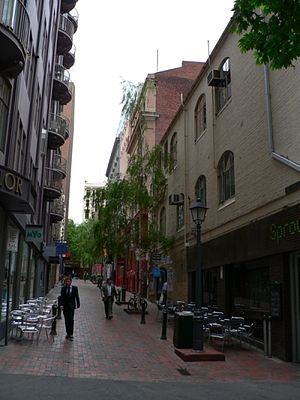
McKillop Street, Melbourne
- McKillop Street, Melbourne
-

McKillop Street looking north from Little Collins
McKillop Street is a street in Melbourne, Victoria. It is a short, quiet and narrow open laneway, running between Bourke Street and Little Collins Street between Queen Street and Elizabeth Street in the central business district of Melbourne.
Located between the financial centre and shopping precinct, McKillop Street is currently flanked by some small boutique shops and outdoor dining cafes.
The lane is paved with red brick, has several trees and heritage style lampposts along it and restricted access to cars. There are some heritage buildings converted into apartments along the street.
External links
| v · d · eStreets of Melbourne's Hoddle Grid |
|
| Latitudinal streets |
|
|
| Longitudinal streets |
|
|
| Significant lanes |
|
|
| Significant arcades |
|
|
References
Coordinates: 37°48′55″S 144°57′42″E / 37.81528°S 144.96167°E / -37.81528; 144.96167
Categories: - Streets in Melbourne
- Heritage sites in Melbourne
Wikimedia Foundation.
2010.
Look at other dictionaries:
Collins Street, Melbourne — Collins Street Looking down Collins Street from Southern Cross Station Length: 2 km (1 mi) Location: Melbourne C … Wikipedia
Degraves Street, Melbourne — Degraves laneway Degraves Street is a street in Melbourne, Victoria. It is named after Charles and William Degraves, pioneer merchants who settled in Melbourne from Hobart, Tasmania in 1849. William Degraves (1821–1883) was also a large scale… … Wikipedia
Market Street, Melbourne — Market Street, facing north from Flinders Street Market Street is one of the north south streets in the central business district of Melbourne, Australia, part of the Hoddle Grid laid out in 1837. Market Street is the only major deviation to the… … Wikipedia
McKillop — McKillop, MacKillop, Mackillop may refer to: People McKillop (surname), the surnames McKillop, MacKillop, and Mackillop Places Electoral district of MacKillop Huron East, Ontario (redirect from McKillop Township) McKillop No. 220, Saskatchewan… … Wikipedia
Melbourne City Centre — This article is about the locality within the postcodes 3000, 3004 and 3006 of Melbourne in Victoria, Australia, officially known as Melbourne . For the Greater Melbourne metropolitan area, see Melbourne. For the local government area that… … Wikipedia
Lanes and arcades of Melbourne — See also: List of lanes and arcades in Melbourne city centre The lanes and arcades of Melbourne, Australia, have collectively become culturally important. The Melbourne central business district s numerous lanes mostly date to the Victorian era… … Wikipedia
Howey Place, Melbourne — Howey Place looking south from Little Collins Howey Place, formerly known as Cole s Walk is a shopping arcade in Melbourne, Victoria. It is a short, narrow covered laneway, running south from Little Collins Street between Swanston Street and… … Wikipedia
Niagara Lane, Melbourne — Niagara lane looking south from Lonsdale street. Niagara Lane is a small lane in the Melbourne CBD, Australia. It runs roughly north south between Bourke Street and Little Bourke Street. The lane is named after the Niagara buildings, early 20th… … Wikipedia
List of lanes and arcades in Melbourne city centre — A list of lanes in Hoddle Grid.* ACDC Lane * Albert Coates Lane (Queen Victoria Village) * Artemis Lane (Queen Victoria Village) * Bank Place * Beaney Lane * Bennetts Lane * Bligh Place * Block Place * Brown Alley * Centre Place * Chapter House… … Wikipedia
Hoddle Grid — The Hoddle Grid is the layout of the streets in the centre of the central business district of Melbourne. Named after its designer, Robert Hoddle, the Grid was laid out in 1837, and later extended. It covers the area from Flinders St to Queen… … Wikipedia

