- Transport in Greater Tokyo
-
The transport network in Greater Tokyo includes public and private rail and highway networks; airports for international, domestic, and general aviation; buses; motorcycle delivery services, walking, bicycling, and commercial shipping. While the nexus is in the central part of Tokyo, every part of the Greater Tokyo Area has rail or road transport services. The sea and air transport is available from limited number of ports for the general public.
Public transport within Greater Tokyo is dominated by one of the world's most extensive urban rail networks of clean and efficient surface trains and subways run by a variety of operators, with buses, trams, monorails, and other modes supporting the railway lines.[1] 40 million passengers use the rail system daily(14.6 billion annually) with the subway representing 22% of that figure with 8.66 million using it daily.[2] There are 0.61 commuter rail stations in the Tokyo area per square mile (one for each 1.6 square miles) of developed land area, though there are more in Osaka and Nagoya, combined with the high density connecting bus networks, Commuter rail ridership is very dense, at 6 million people per line mile annually, with the highest among automotive urban areas.[3] Walking and cycling are much more common than in many cities around the globe. Private automobiles and motorcycles play a secondary role in urban transport.
Contents
Air
Primary airports
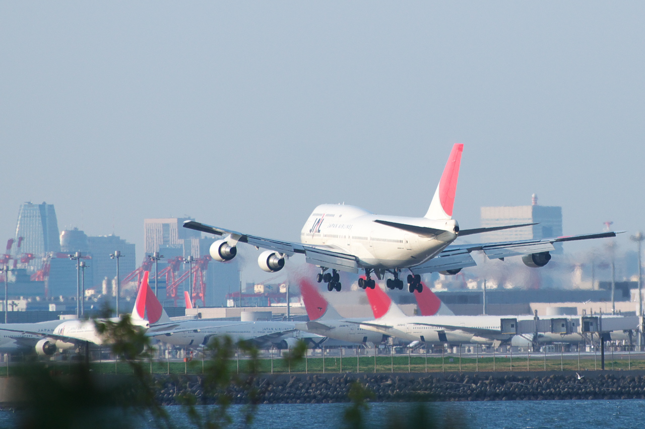
 Tokyo International Airport
Two airports handle the vast majority of commercial flights in the region. Haneda Airport in Ōta, Tokyo is the domestic hub for Japan's flag carrier Japan Airlines and has recently become a new hub for some international flights. The other, Narita International Airport in Narita, Chiba Prefecture is the international gateway airport to the region. Both airports have completed expansions, despite this Tokyo is still congested, though not severely like before 2011.
Secondary airports
Chofu Airport in the city of Chōfu in western Tokyo handles commuter flights to the Izu Islands, which are administratively part of Tokyo. Tokyo Heliport in Kōtō serves public-safety and news traffic. In the Izu Islands, Ōshima Airport on Ōshima, Hachijōjima Airport on Hachijō, and Miyakejima Airport on Miyake provide air services.
Ibaraki Airport, located 85 km north of Tokyo, was positioning itself as a hub for low-cost carriers, flights from here to Sapporo seem to be the most popular. Shizuoka Airport, 175 km southwest of Tokyo, aims to be a more convenient alternative for Shizuoka residents than airports in Tokyo or Nagoya, however none of the above airports have shown to take away any significant traffic from Narita or Haneda and continue to play minor roles.
Military
In addition, the Greater Tokyo area has military bases with airfields:
- Yokota Air Base (USAF/JASDF)
- NAF Atsugi (USN/JMSDF)
Helipads
There is also a limited number of helicopter transport services in Tokyo, with one service linking Narita airport with central Tokyo.[4]
Rail
Overview
Rail is the primary mode of transport in Tokyo. Tokyo has the most extensive urban railway network and the most used in the world with 40 million passengers in the metro area daily. [5] There are 882 interconnected rail stations in the Tokyo Metropolis, 282 of which are Subway stations.[6], with several hundred more in each of the 3 surrounding suburban prefectures. There are 30 operators running 121 passenger rail lines (102 serving Tokyo and 19 more serving Greater Tokyo but not Tokyo's city center itself), excluding about 12 cable cars. Despite this vastness, the network is still being expanded, albeit with more service upgrades and fewer new lines. Each of the region's rail companies makes their own maps, with key transfer points highlighted. Trains are often extremely crowded at peak travel times, with people being pushed into trains by so-called oshiya ("pushers"). Most lines in Tokyo are privately owned and operated, though the Toei Subway is run directly by the Tokyo Metropolitan Government and Tokyo Metro is owned indirectly by the Tokyo and national governments. Rail and subway lines are highly integrated and dense; commuter trains from the suburbs continue directly into the subway network on many lines, often emerging on the other side of the city to serve another company's surface commuter line. Shinjuku Station is the busiest train station in the world by passenger throughput.[7] It is estimated some 20 million people use rail as their primary means of transport (not trips) in the metropolitan area daily. In comparison, the entire country of Germany, with the highest per-capita railway use in Europe, has 10 million daily train riders.[8]
Busiest stations
Passengers carried in Greater Tokyo stations daily (2007):
- Shinjuku Station 3.64 million (Registered with Guinness World Records)[9]
- Ikebukuro Station 2.71 million[10]
- Shibuya Station 2.18 million[11]
- Yokohama Station 2.09 million[12]
- Tokyo Station 1.12 million[13]
- Shinagawa Station 0.91 million[14]
- Takadanobaba Station 0.90 million [15]
- Shimbashi Station 0.85 million[16]
Japan Rail
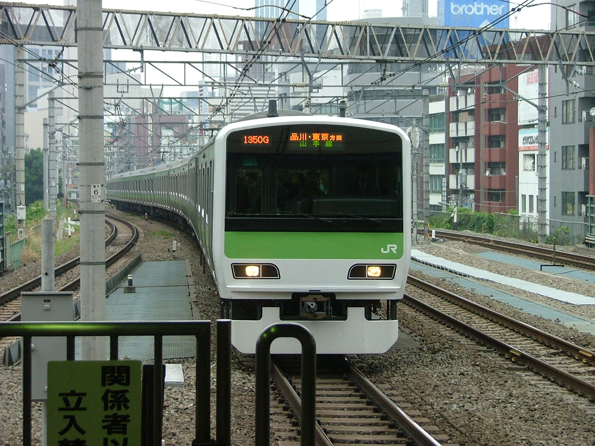
East Japan Railway Company, or JR East, is the largest passenger railway company in the world. It operates trains throughout the Greater Tokyo area (as well as the rest of northeastern Honshū).
In addition to operating some long-haul shinkansen ("bullet train") lines, JR East operates Tokyo's largest commuter railway network. This network includes the Yamanote Line, which encircles the center of Tokyo; the Keihin-Tōhoku Line between Saitama and Yokohama; the Chūō Line to western Tokyo; the Sōbu Line and Keiyō Line to Chiba; and the Yokohama, Tōkaidō, and Yokosuka lines to Kanagawa.
Many additional lines form a network outside the center of the city, allowing inter-suburban travel. Among these are the Hachikō, Itsukaichi, Jōban, Jōetsu, Kawagoe, Musashino, Ōme, Negishi, Nambu, Sagami, Takasaki, and Tsurumi lines. In total, JR alone operates 23 lines within the Greater Tokyo area.
JR East is also the majority shareholder in the Tokyo Monorail, one of the world's most commercially successful monorail lines.
Other railway operators serving central Tokyo
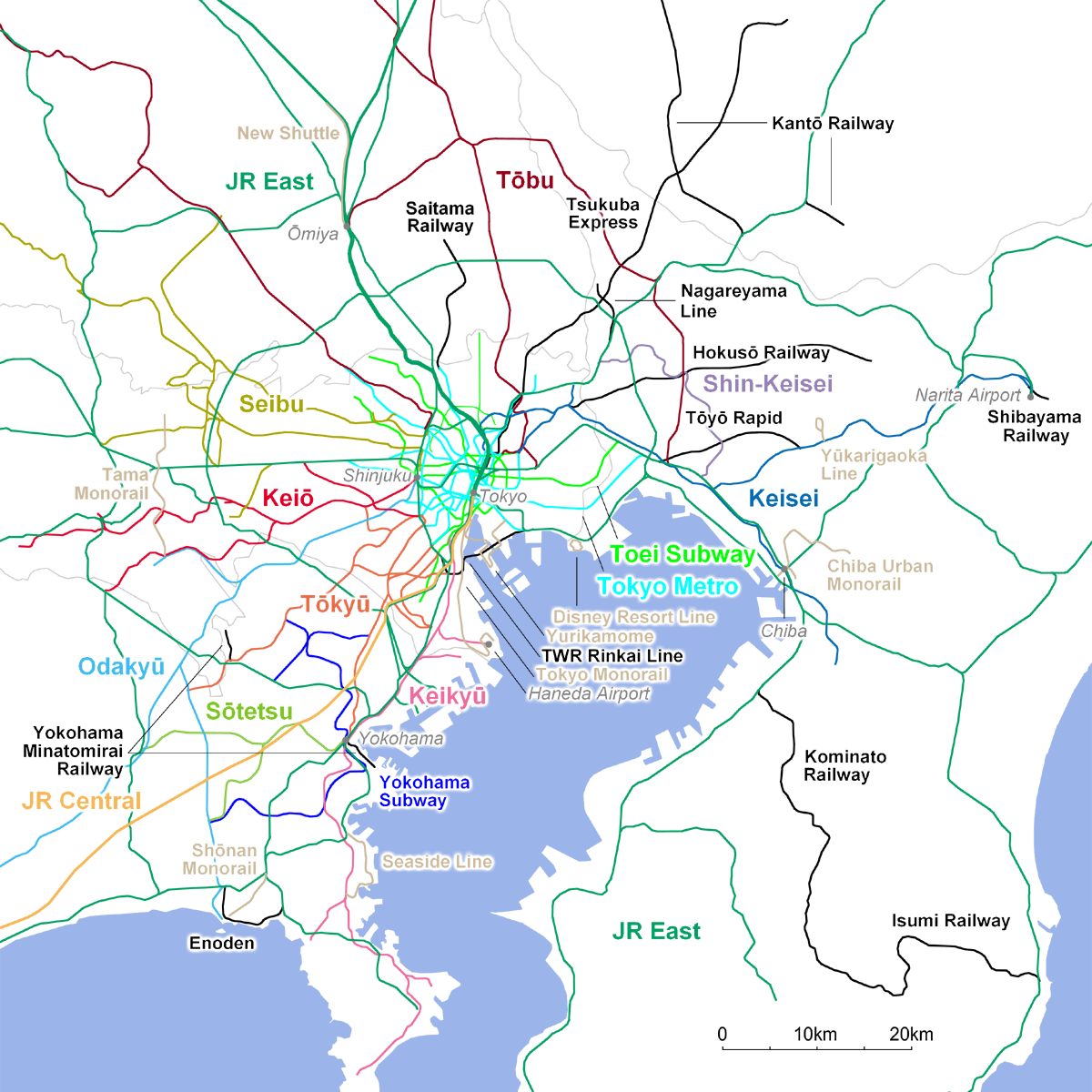
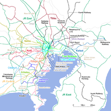 Map of operators in Greater Tokyo Area
Regional railways transport commuters from the suburbs to central Tokyo. These include several private railway networks that own and operate a total of 55 lines serving Tokyo. These same operators indirectly operate another 24 lines outside of Tokyo as well as a few tourist-oriented aerial lifts and funiculars.
- Keihin Electric Express Railway (Keikyū): Operates out of Shinagawa Station to Kanagawa and Haneda Airport. Five lines.
- Keio Corporation: Operates out of Shinjuku Station and Shibuya Station to western Tokyo. Six lines.
- Keisei Electric Railway: Operates out of Ueno Station to Chiba (including Narita International Airport). Seven lines.
- Odakyū Electric Railway: Operates out of Shinjuku Station to Kanagawa, most notably Odawara and Hakone. Three lines.
- Seibu Railway: Operates out of Seibu Shinjuku Station and Ikebukuro Station to western Tokyo. Thirteen lines.
- Tōbu Railway: Operates out of Ikebukuro Station and Asakusa Station to Saitama, Gunma, and Tochigi. Twelve lines.
- Tōkyū Corporation (Tōkyū): Operates out of Shibuya Station and Meguro Station to southern Tokyo and Yokohama. Eight lines.
- Metropolitan Intercity Railway Company (Tsukuba Express or TX): Links Akihabara Station with Tsukuba. One line.
Some private and public carriers operate within the boundaries of Tokyo.
- Tama Toshi Monorail: A suburban transit line running north/south through Western Tokyo.
- Tokyo Monorail: Connects central Tokyo to Haneda Airport.
- Tokyo Waterfront Area Rapid Transit: Operates the Rinkai Line along the Tokyo waterfront to Odaiba.
- Yurikamome: People mover serving the Tokyo waterfront and Odaiba.
Subways operators
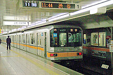 The Ginza Line, Asia's oldest subway line, first opened in 1927
Two organizations operate the Tokyo subway network:
- Tokyo Metro (formerly Eidan): Operates Tokyo's (and Japan's) largest subway network, with nine lines.
- Tokyo Metropolitan Bureau of Transportation: Operates the four Toei subway lines as well as the following:
- Toden Arakawa Line: Once a common sight before subways and buses came to fore, the streetcar network has shrunk to only this one route between Waseda Station and Minowabashi Station.
- Nippori-Toneri Liner: People mover in northeast Tokyo owned and operated by the Tokyo Metropolitan Bureau of Transportation.
- Ueno Zoo Monorail — Short monorail in Ueno Zoo.
Suburban railway operators of Greater Tokyo
Railway companies that serve other parts of Greater Tokyo include:
- Chiba Urban Monorail: Serving the city of Chiba.
- Disney Resort Line: A monorail that links Maihama Station and Tokyo Disney Resort.
- Enoshima Electric Railway (Enoden): Scenic rail line running between Kamakura and Fujisawa in southern Kanagawa.
- Hokusō Railway: Northeast Chiba Prefecture.
- Sagami Railway (Sōtetsu): Serves eastern Kanagawa. Three lines.
- Saitama New Urban Transit (New Shuttle): A people mover in central Saitama.
- Saitama Rapid Railway: A commuter line connecting southern Saitama to Tokyo.
- Kanazawa Seaside Line: People mover in southern Yokohama.
- Shibayama Railway: A short railway line in northern Chiba.
- Shin-Keisei Electric Railway: A commuter line in northwest Chiba.
- Shōnan Monorail: A monorail connecting Fujisawa Station to the Shōnan coast.
- Ryūtetsu: A short line railway in Nagareyama, Chiba.
- Tōyō Rapid Railway: A commuter line in Funabashi and Yachiyo, Chiba.
- Yamaman Yukarigaoka Line: A people mover in Sakura, Chiba.
- Yokohama Minatomirai Railway (Minatomirai Line and Kodomo-no-Kuni Line): Owns two lines in Yokohama; operations are subcontracted to Tokyu Corporation.
- Yokohama Municipal Subway: Owned and operated by the Yokohama city government. Two lines.
Ridership
Below is the annual ridership of each major operator as of the 2007 fiscal year.[17] Transfers between operators are not counted unless they pass through a ticketing gate (not simply a platform).
Operator Annual ridership (millions) East Japan Railway Company 5,459.000 [18] Tokyo Metro 2,321.770 [19] Tōbu Railway 877.683 [19] Tōkyū Corporation 1,065.439 [19] Toei Subway 1,705.959[20] Odakyū Electric Railway 717.211 [19] Seibu Railway 628.781 [19] Keio Corporation 637.180 [19] Keihin Electric Express Railway 444.157 [19] Keisei Electric Railway 258.505 [19] Sagami Railway 230.889 [19] Total 14,346.574 Buses
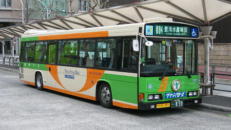
Public buses in Greater Tokyo usually serve a secondary role, feeding bus passengers to and from train stations. Exceptions are long distance bus services, buses in areas poorly served by rail (not many exist), and airport bus services for people with luggage. Tokyo Metropolitan Bureau of Transportation operates Toei buses mainly within the 23 special wards while private bus companies (mostly the subsidiaries of the large train operators listed above) operate other bus routes, as do other city governments, such as Kawasaki City Bus, Yokohama City Bus, etc. Toei buses have a fixed fare of 200 yen[21] per ride, while most other companies charge according to distance. Some train operators offer combined bus/train tickets; special fares apply for children, seniors and the disabled. Some routes feature non-step buses with a kneeling function to assist mobility-impaired users.[22]
Taxis
Taxis also serve a similar role to buses, supplementing the rail system, especially after midnight when most rail lines cease to operate. People moving around the city on business often chose taxis for convenience, as do people setting out in small groups.
As of December 2007[update], taxis cost ¥710 (~$7.89 at ¥90/$1 USD) for the first two kilometers, and ¥90 for every 288 meters thereafter, or approximately ¥312.5 per kilometer. Most companies tend to raise fares by 20% between 22:00-5:00, but other companies have kept fares low to compete in a crowded market.[23][24]
Roads
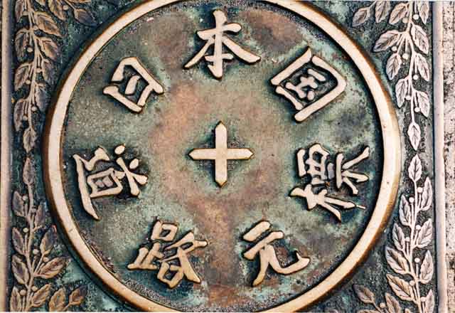
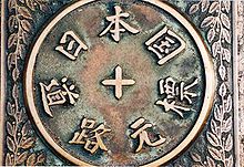 This marker in Nihonbashi is the place from which distances along highways are reckoned
Local and regional highways
National, prefectural and metropolitan, and local roads crisscross the region. Some of the major national highways are:
- Route 1 links Tokyo to Osaka along the old Tōkaidō
- Route 6 and Route 4 carries traffic north all the way to Sendai and Aomori respectively.
- Route 14 connects Nihonbashi with Chiba Prefecture.
- Route 16 is a heavily travelled circumferential linking Yokosuka, Yokohama, western Tokyo, Saitama, and Chiba.
- Route 17 originates in central Tokyo and passes through Saitama en route to Niigata Prefecture.
- Route 20 crosses Tokyo from east to west, continuing into Yamanashi Prefecture.
The datum from which distances are reckoned is in Nihonbashi.
Expressways
The Shuto Expressway network covers central Tokyo, linking the intercity expressways together, while primarily serving commuters and truck traffic. The Bayshore Route bypasses Tokyo by traveling from Kanagawa Prefecture in between, above, and under manmade islands around Tokyo Bay to Chiba Prefecture. The Tokyo Bay Aqua-Line, which goes underneath Tokyo Bay, links Kawasaki to Kisarazu in Chiba Prefecture. Important regional expressways include the Tokyo Gaikan Expressway, Daisan-Keihin Road, and Keiyō Road. Presently under construction (with some segments operating), the Ken-Ō Expressway will be a major circumferential through the area.
Many long-distance expressway routes converge at Tokyo including the Tōmei Expressway, Chūō Expressway, Kan-Etsu Expressway, and Tōhoku Expressway.
Maritime transport
Passenger ferries
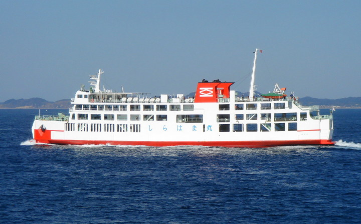
 Tokyo-Wan Ferry Shirahama-maru
The notable route which serves as internal transport is Tokyo-Wan Ferry, the car-passenger ferry route between Yokosuka, Kanagawa and Futtsu, Chiba,[25] crossing Tokyo Bay. Other passenger services within the bay are mostly used as scenic cruises, such as Tokyo Cruise Ship and Tokyo Mizube Line in Tokyo, The Port Service and Keihin Ferry Boat in Yokohama.
Out of the bay, the car-passenger ferries to the Izu Islands and the Ogasawara Islands, Shikoku, Kyūshū, the Amami Islands and Okinawa serve from the ports of Tokyo or Yokohama.[26] The car-passenger ferries to Hokkaidō serve from Ōarai, Ibaraki.[26] There are some other freight ferries (which can carry less than 13 passengers) serving out of the Bay.
Shipping
Shipping plays a crucial role for inbound and outbound freight, both domestic and international. The Port of Tokyo and Port of Yokohama are both major ports for Japan and Greater Tokyo.
See also
- Transport in Greater Osaka
- Transport in Greater Nagoya
- Transport in Fukuoka-Kitakyūshū
References
- ^ name="Urban Transport Factbook"
- ^ http://www.mlit.go.jp/kisha/kisha07/01/010330_3/01.pdf
- ^ Urban Transport Factbook, Tokyo-Yokohama Suburban Rail Summary
- ^ http://search.japantimes.co.jp/cgi-bin/nn20090314f1.html
- ^ http://www.mlit.go.jp/kisha/kisha07/01/010330_3/01.pdf
- ^ There are 0.61 commuter rail stations in the Tokyo area per square mile (one for each 1.6 square miles) of developed land area, though there are more in Osaka and Nagoya, combined with the high density connecting bus networks, Commuter rail ridership is very dense, at 6 million people per line mile annually, with the highest among automotive urban areas. Urban Transport Factbook, Tokyo-Yokohama Suburban Rail Summary
- ^ According to the Shinjuku Station article, the station was used by an average of 3.64 million people per day in 2007. It is registered with Guinness World Records.
- ^ BBC NEWS | Business|German train strike brings chaos
- ^ JR East 1,571,602 (785,801×2), Odakyū 498,918, Keiō 747,407l, Toei 262,688+130,800, Tokyo Metro 240,984, Seibu 188,184
- ^ JR East 1,179,674, Tobu 519,271, Seibu 520,164, Tokyo Metro 491,958
- ^ JR East 891,460, Tokyu 414,833+680,395, Tokyo Metro Hanzoumon Line 472,123+258,609, Keio 343,697
- ^ JR East 806,788, Yokohama Municipal Subway 132,290 (66,145×2), Keikyū 308,041, Tokyu 323,851, Yokohama Minatomirai Railway 134,830, Railway 440,986
- ^ JR East 792,304, JR Central 190,000 (95,000×2), Tokyo Metro 140,486
- ^ JR East 648,506, JR Central 21,872, Keikyū 242,804
- ^ JR East 424,572, Seibu 294,094, [http://www.tokyometro.jp/corporate/data/jinin/index.html Tokyo Metro 187,458
- ^ JR East 499,214, Tokyo Metro 217,790, Toei 78,139, Yurikamome 58,824
- ^ The figures are those of directly operated lines, without subsidiary or related company lines. The actual total figure is higher than shown here as smaller operators are not listed.
- ^ JR East 2009 Annual Report, p. 94. Accessed March 24, 2010.
- ^ a b c d e f g h i 大手民鉄16社の鉄軌道部門輸送実績(2008年度) Accessed March 24, 2010.
- ^ 各駅乗降人員一覧, Tokyo Metropolitan Bureau of Transportation, Accessed March 24, 2010.
- ^ Toei Transportation Information: Operations
- ^ Toei Bus official website: 50% of buses are now non-step buses.
- ^ http://www.zimbio.com/Japan/articles/707/Taxi+fares+get+first+price+hike+Tokyo+Kanagawa
- ^ http://iguide.travel/Tokyo/Getting_Around/By_taxi
- ^ ja:東京湾フェリー as of 2007-08-01T09:48 retrieved on 2007-09-07.
- ^ a b ja:日本のフェリー会社一覧 as of 2007-09-05T13:17 retrieved on 2007-09-07.
External links
- JR East official website, showing the map of the Suica/PASMO accepting area, which roughly corresponds with Greater Tokyo Area (Japanese)
- Greater Tōkyō Railway Network, unofficial railway map of Greater Tokyo (English)
- Tokyo Railway Map, bilingual railway map of central Tokyo (Japanese) (English)
Tokyo Metropolis Special Wards 

Cities Districts and
SubprefecturesCategories:- Transport in Tokyo
- Transport in Japan

Wikimedia Foundation. 2010.