- Chōfu, Tokyo
-
Chōfu
調布市— City — 
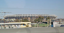
FlagLocation of Chōfu in Tokyo Metropolis Coordinates: 35°39′2.21″N 139°32′26.5″E / 35.6506139°N 139.540694°ECoordinates: 35°39′2.21″N 139°32′26.5″E / 35.6506139°N 139.540694°E Country Japan Region Kantō Prefecture Tokyo Metropolis Government - Mayor Yoshiki Nagatomo (since July 2002) Area - Total 21.53 km2 (8.3 sq mi) Population (June 1, 2010) - Total 224,878 - Density 10,440/km2 (27,039.5/sq mi) Time zone Japan Standard Time (UTC+9) City Symbols - Tree Cinnamomum camphora - Flower Lagerstroemia indica - Bird Japanese White-eye Phone number 042-481-7111 Address 2-35-1 Kojima-cho, Chōfu-shi, Tokyo-to 182-8511 Website Chōfu city official HP Chōfu (調布市 Chōfu-shi) is a city located in the western end of Tokyo Metropolis, Japan. As of 2010, the city has an estimated population of 224,878 and a population density of 10,440 persons per km². The total area was 21.53 km². Tokyo Stadium (commonly known as Ajinomoto Stadium) in Chōfu hosts soccer games for two J. League teams: F.C. Tokyo and Tokyo Verdy.
Contents
Geography
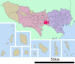
Chōfu is approximately in the geographic center of Tokyo Metropolis, on the Musashino Terrace bordered by the floodplains of the Tama River.
Surrounding municipalities
- Setagaya, Tokyo
- Mitaka, Tokyo
- Fuchu, Tokyo
- Koganei, Tokyo
- Komae, Tokyo
- Inagi, Tokyo
- Kawasaki, Kanagawa
History
The area of present day Chōfu has been inhabited since Japanese Paleolithic times, and numerous remains from the Jōmon, Yayoi and Kofun periods have been discovered. During the Nara period, it became part of ancient Musashi Province. During the Sengoku period, the area was frequently contested between the Late Hōjō clan and Uesugi clan. During the Edo period, the area prospered as a post station on the Kōshū Kaidō and as a center for silkworm production.
The in post-Meiji Restoration cadastral reform of April 1, 1889, Chōfu Town and neighboring Jindai Village were established within Kanagawa Prefecture. The entire district was transferred to the control of Tokyo Metropolis on April 1, 1893. Jindai was elevated to town status on November 3, 1952 and merged with Chōfu Town on April 1, 1955 to form the present city of Chōfu.
Economy
Chōfu is primarily a regional commercial center, and a bedroom community for central Tokyo.
The headquarters of the Japan Aerospace Exploration Agency are also located in the city.
Transportation
Railroad
- Keio Electric Railway – Keiō Line
- Sengawa - Tsutsujigaoka - Shibasaki - Kokuryō - Fuda - Chōfu - Nishi-Chōfu
- Keio Electric Railway – Keiō Sagamihara Line
Highway
Airport
Education
- University of Electro-Communications
- Tokyo University of Foreign Studies
- Toho Gakuen School of Music
- Shirayuri Women's University
- Jikei University School of Medicine
Chōfu is also home to the American School in Japan, a K-12 institution attended by many American and international children.
Local attractions
Every July, Chōfu hosts the Chōfu City Fireworks Festival, attended by as many as 300,000 people along the banks of the Tamagawa River. The tiny Fuda Station on the Keio Line is inundated on this one day with tens of thousands of visitors.[citation needed]
Chōfu has a large cultural centre which supports many groups encouraging the integration of foreigners into Japanese society, providing free Japanese, Shodo, Ikebana, Karate (and many other) lessons.
There is the park and memorial hall commemorating the life of novelist Mushanokōji Saneatsu, a former resident of Chōfu.
For the 1964 Summer Olympics, the city served as part of the route for the athletic 50 kilometer walk and marathon events.[1]
Noted people from Chōfu
- Kondō Isami – Bakumatsu period samurai
- Saneatsu Mushanokōji – novelist, playwright, poet
- Nobuko Imai - violinist
- Oku Shutaro – director
- Junji Takada - actor
References
- ^ 1964 Summer Olympics official report. Volume 2. Part 1. pp. 74-5.
External links
- Chōfu official website in English
- Chōfu official website in Japanese
- Tokyo/Chofu travel guide from Wikitravel
Tokyo Metropolis Architecture · Education · Festivals · History · Politics · Sports · Tourism · Transportation Special Wards 

Cities Akiruno · Akishima · Chōfu · Fuchū · Fussa · Hachiōji · Hamura · Higashikurume · Higashimurayama · Higashiyamato · Hino · Inagi · Kiyose · Kodaira · Koganei · Kokubunji · Komae · Kunitachi · Machida · Mitaka · Musashimurayama · Musashino · Nishitōkyō · Ōme · Tachikawa · Tama
Districts and
SubprefecturesPortal · Category Venues of the 1964 Summer Olympics Asaka Nezu Park · Asaka Shooting Range · Chofu City · Enoshima · Fuchu City · Hachioji City · Hachioji Velodrome · Karasuyama-machi · Karuizawa · Kemigawa · Komazawa Gymnasium · Komazawa Hockey Field · Komazawa Olympic Park Stadium · Komazawa Volleyball Courts · Korakuen Ice Palace · Lake Sagami · Mitsuzawa Football Field · Osaka Nagai Stadium · National Gymnasium · Tokyo National Stadium · Nippon Budoka Hall · Nishikyogoku Athletic Stadium · Ōmiya Football Field · Prince Chichiba Memorial Football Field · Sasazuka-machi · Shibuya Public Hall · Shinjuku · Toda Rowing Course · Tokorozawa Shooting Range · Tokyo Metropolitan Gymnasium · Tokyo Metropolitan Indoor Swimming Pool · Waseda Memorial Hall · Yokohama Cultural GymnasiumCategories:- 1964 Summer Olympic venues
- Cities in Tokyo
- Western Tokyo
Wikimedia Foundation. 2010.


