- Special wards of Tokyo
-
Special wards of Tokyo
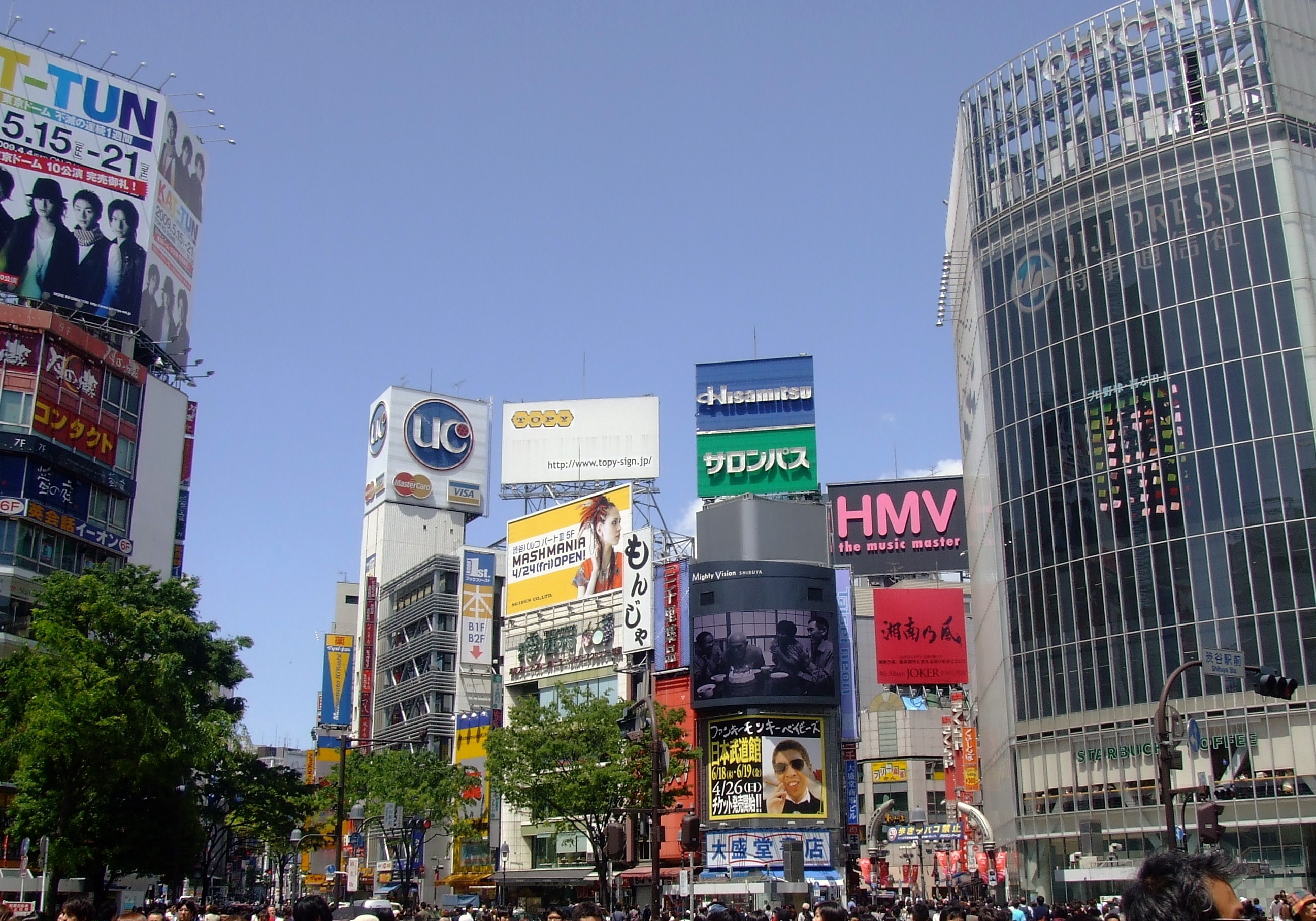
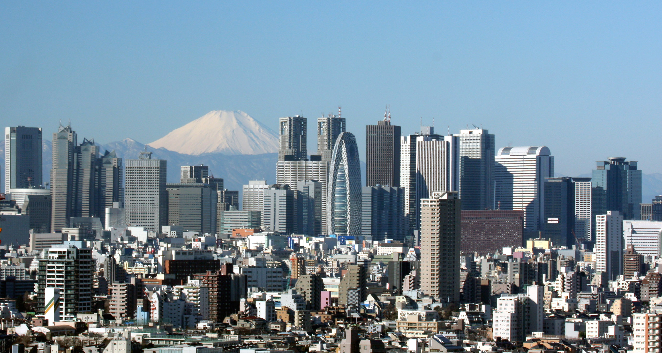
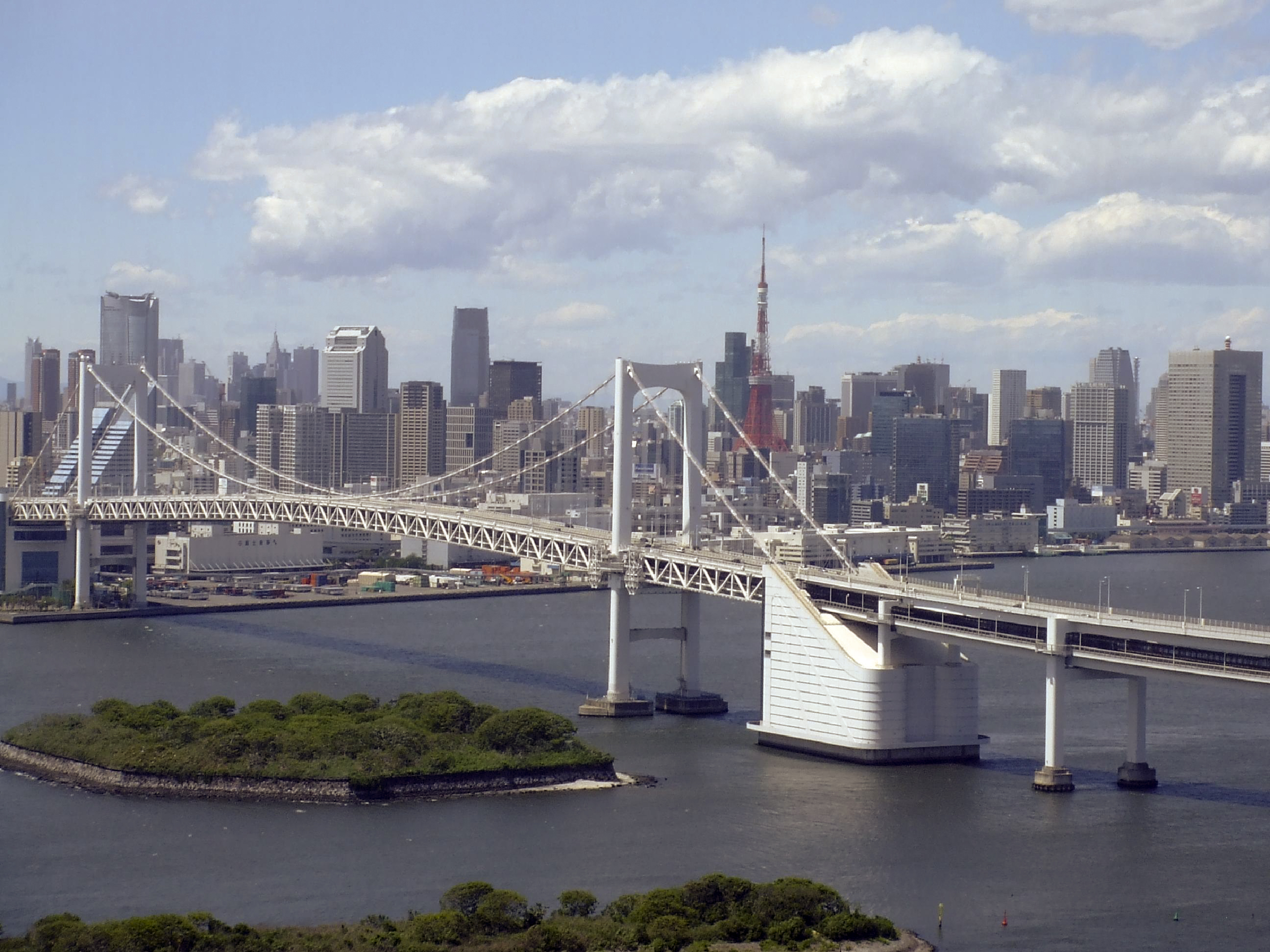
東京特別区Clockwise from top: Rainbow Bridge, Shinjuku, the Tokyo Tower, Shibuya, and the National Diet Building

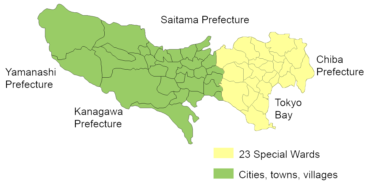
Country Japan Island Honshū Region Kantō Prefecture Tokyo Area – 23 special wards 621.9 km2 (240.1 sq mi) Population (January 1, 2009) – 23 special wards 8,742,995 – Density 14,061/km2 (36,418/sq mi) The special wards (特別区 tokubetsu-ku) are 23 municipalities that together make up the core and the most populous part of Tokyo, Japan. Together, they occupy the land that was the city of Tokyo before it was abolished in 1943. The special wards' structure was established under the Japanese Local Autonomy Law and is unique to Tokyo.
In Japanese, they are commonly known as the "twenty-three wards" (23区 nijūsan-ku). All wards refer to themselves as cities in English, even though the Japanese designation of tokubetsuku is unchanged.
It is merely a grouping of special wards, there is no associated single government body.
Contents
Differences from municipalities
Although special wards are autonomous from the Tokyo metropolitan government, they also function as a single urban entity in respect to certain public services, including water supply, sewage disposal, and fire services. These services are handled by the Tokyo metropolitan government, whereas cities would normally provide these services themselves. To finance the joint public services it provides to the twenty-three wards, the metropolitan government levies some of the taxes that would normally be levied by city governments, and also makes transfer payments to wards that cannot finance their own local administration.
Unlike municipalities (including the municipalities of western Tokyo), special wards are not considered to be local public entities for purposes of the Constitution of Japan. This means that they have no constitutional right to pass their own legislation, or to hold direct elections for mayors and councilors. While these authorities are currently granted by statute, they may be unilaterally revoked by the Diet of Japan; similar measures against other municipalities would require a constitutional amendment.
History
The word "special" distinguishes them from the wards (区 ku) of other major Japanese cities. Before 1943, the wards of Tokyo City were no different from the wards of Osaka or Kyoto. These original wards originally numbered 15 in 1889, and over the years came to expand to the current city area, reaching a number of 35 wards. On March 15, 1943, when the Tokyo city government and prefectural government merged into a single prefectural government, the wards were placed under the direct control of the prefecture. 35 wards of the former city were integrated into 22 on March 15, 1947 just before the legal definition of special wards was given by the Local Autonomy Law, enforced on May 3 the same year. The 23rd ward, Nerima, was formed on August 1, 1947 when Itabashi was split again.
Since the 1970s, the special wards of Tokyo have exercised a considerably higher degree of autonomy than the wards in other cities, making them more like independent cities than districts. Each special ward has its own elected mayor (区長 kuchō) and assembly (区議会 kugikai). In 2000, the National Diet designated the special wards as local public entities (地方公共団体 chihō kōkyō dantai), giving them a legal status similar to cities.
The wards vary greatly in area (from 10 to 60 km²) and population (from less than 40,000 to 830,000), and some are expanding as artificial islands are built. Setagaya has the most people, while neighboring Ōta has the largest area.
The total population (census) of the twenty-three special wards was 8,483,140 as of October 1, 2005,[1] about two-thirds of the population of Tokyo and a quarter of the population of the Greater Tokyo Area. The twenty-three wards have a population density of 13,800 per square kilometre (35,600 per square mile). As of August 2008, the population was 8,731,434 according to the Japan Statistical Agency.[citation needed]
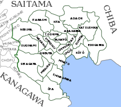
List of special wards
Name Kanji Population
(as of June 2007[update])Density
(/km²)Area
(km²)Major districts  Adachi
足立区 629,392 11,830.68 53.20 Ayase, Kitasenju, Takenotsuka  Arakawa
荒川区 194,777 18,262.25 10.20 Arakawa, Machiya, Nippori, Minamisenju  Bunkyō
文京区 194,933 16,009.28 11.31 Hongō, Yayoi, Hakusan  Chiyoda
千代田区 43,802 3,763.06 11.64 Nagatachō, Kasumigaseki, Ōtemachi, Marunouchi, Akihabara, Yūrakuchō, Iidabashi  Chūō
Chūō中央区 104,997 10,344.53 10.15 Nihonbashi, Kayabachō, Ginza, Tsukiji, Hatchōbori, Shinkawa, Tsukishima, Kachidoki, Tsukuda,  Edogawa
江戸川区 661,386 13,264.86 49.86 Kasai, Koiwa  Itabashi
板橋区 529,059 16,445.72 32.17 Itabashi, Takashimadaira  Katsushika
葛飾区 428,066 12,286.62 34.84 Tateishi, Aoto  Kita
Kita北区 330,646 15,885.67 20.59 Akabane, Ōji, Tabata  Kōtō
Kōtō江東区 436,337 10,963.24 39.8 Kiba, Ariake, Kameido, Tōyōchō, Monzennakachō, Fukagawa, Kiyosumi, Shirakawa, Etchūjima, Sunamachi, Aomi  Meguro
目黒区 267,798 18,217.55 14.70 Meguro, Nakameguro, Jiyugaoka  Minato
港区 205,196 10,088.30 20.34 Odaiba, Shinbashi, Shinagawa, Roppongi, Toranomon, Aoyama, Azabu, Hamamatsuchō, Tamachi  Nakano
中野区 312,939 20,097.82 15.59 Nakano  Nerima
練馬区 702,202 14,580.61 48.16 Nerima, Ōizumi, Hikarigaoka  Ōta
Ōta大田区 674,590 11,345.27 59.46 Ōmori, Kamata, Haneda, Den-en-chōfu  Setagaya
世田谷区 855,416 14,728.23 58.08 Setagaya, Kitazawa, Kinuta, Karasuyama, Tamagawa  Shibuya
渋谷区 205,512 13,337.13 15.11 Shibuya, Ebisu, Harajuku, Hiroo, Sendagaya, Yoyogi  Shinagawa
品川区 353,887 15,576.01 22.72 Shinagawa, Gotanda, Ōsaki, Hatanodai, Ōimachi  Shinjuku
新宿区 309,463 16,975.48 18.23 Shinjuku, Takadanobaba, Ōkubo, Kagurazaka, Ichigaya  Suginami
杉並区 534,981 15,725.49 34.02 Kōenji, Asagaya, Ogikubo  Sumida
墨田区 237,433 16,079.49 13.75 Kinshichō, Morishita, Ryōgoku  Toshima
豊島区 256,009 19,428.44 13.01 Ikebukuro, Komagome, Senkawa, Sugamo  Taitō
Taitō台東区 168,277 16,139.38 10.08 Ueno, Asakusa Overall 8,637,098 13,890.25 621.81 Places
Many important neighborhoods are located in Tokyo's special wards:
- Akasaka
- A district with a range of restaurants, clubs and hotels; many pedestrian alleys giving it a local neighbourhood feel. Next to Roppongi, Nagatachō, and Aoyama.
- Akihabara
- A densely arranged shopping district for electronics and otaku goods.
- Aoyama
- A neighborhood of Tokyo with parks, an enormous cemetery, expensive housing, trendy cafes and international restaurants. Includes the Omotesandō subway station.
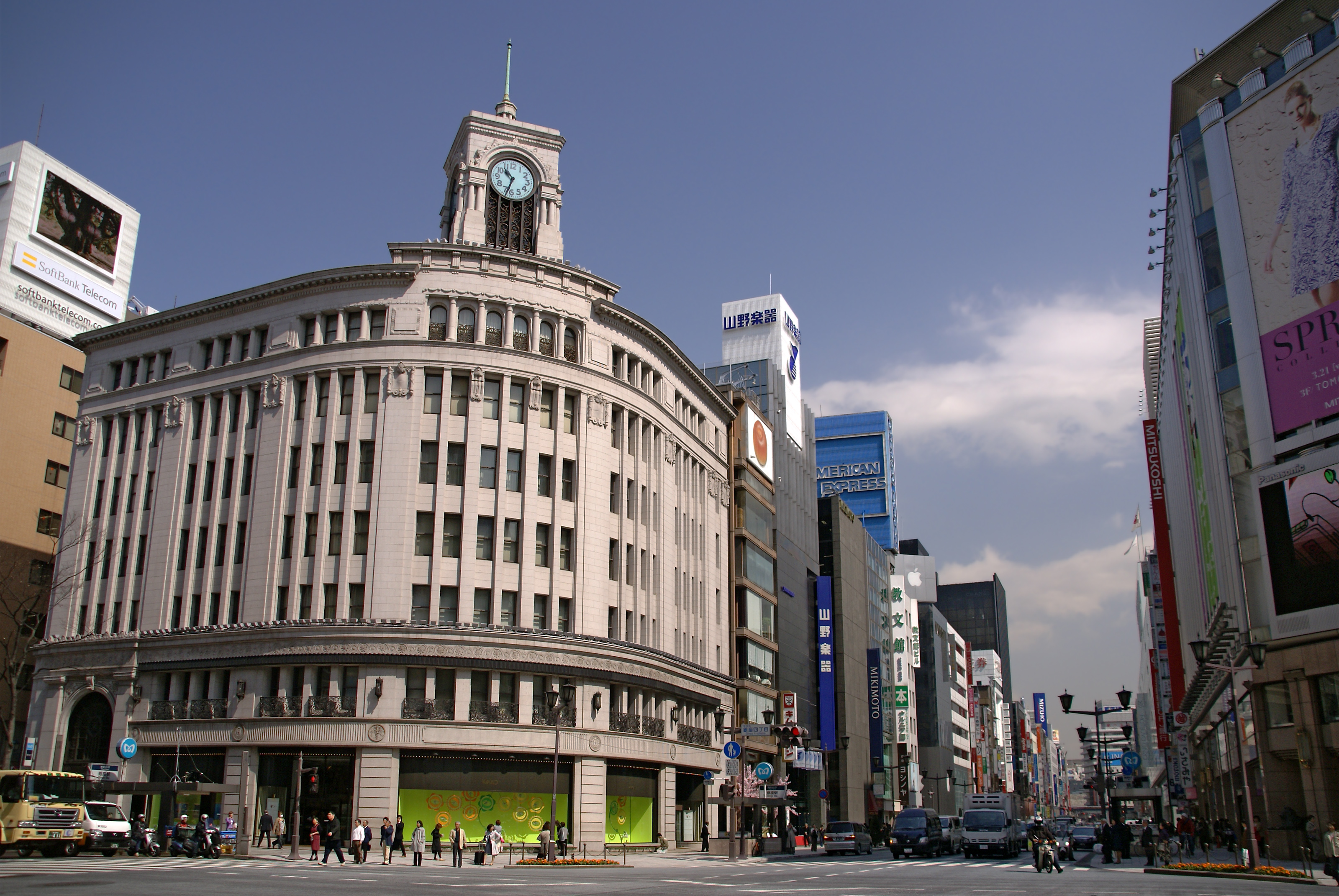
- Ginza and Yūrakuchō
- Major shopping and entertainment district with department stores, upscale shops selling brand-name goods, and movie theaters.
- Harajuku
- Known for its role in Japanese street/teen fashion.
- Ikebukuro
- The busiest interchange in north central Tokyo, featuring Sunshine City and various shopping destinations.
- Jinbōchō
- Tokyo's center of used-book stores and publishing houses, and a popular antique and curio shopping area.
- Marunouchi and Ōtemachi
- The main financial and business district of Tokyo has many headquarters of banks, trading companies and other major corporations. The area is seeing a major redevelopment with new buildings for shopping and entertainment constructed in front of Tokyo Station's Marunouchi side.
- Nagatachō
- The political heart of Tokyo and the nation. It is the location of the Diet, government ministries, and party headquarters.
- Odaiba
- A large, reclaimed, waterfront area that has become one of Tokyo's most popular shopping and entertainment districts.
- Omotesandō
- Known for upscale shopping.
- Roppongi
- Home to the rich Roppongi Hills area, an active night club scene, and a relatively large presence of Western tourists and expatriates.
- Ryōgoku
- The heart of the sumo world. Home to the Ryōgoku Kokugikan and many heya.
- Shibuya
- A long-time center of shopping, fashion, nightlife and youth culture.
- Shinagawa
- In addition to the major hotels on the west side of Shinagawa Station, the former sleepy east side of the station has been redeveloped as a major center for business.
- Shinbashi
- An area revitalized by being the gateway to Odaiba and the Shiodome Shiosite complex of high-rise buildings.
- Shinjuku
- Location of the Tokyo Metropolitan Government Building. The area is best known for Tokyo's early skyscrapers, erected in the 1970s. Major department stores, electronics stores and hotels can also be found here. On the east side of Shinjuku Station, Kabukichō is known for its many bars and nightclubs. Shinjuku Station moves an estimated three million passengers a day, making it the busiest in the world.
- Ueno
- Ueno Station serves commuters to and from areas north of Tokyo. Besides department stores and shops in Ameyoko, Ueno boasts Ueno Park, Ueno Zoo and major national museums. In spring, Ueno Park and adjacent Shinobazu Pond are popular places to view cherry blossoms.
See also
- Capital of Japan
- List of Japanese cities by population
- Local Autonomy Law
- Wards of Japan
- Special cities of Japan (特例市 tokureishi)
References
- ^ 2005 population XLS
External links
- Tokyo Metropolitan Government explanation of special wards (in English)
- Tokyo Metropolitan Government statistics (in Japanese)
Metropolitan cities of Japan Tokyo Metropolis Designated cities Core cities Akita · Amagasaki · Aomori · Asahikawa · Fukuyama · Funabashi · Gifu · Hakodate · Higashiōsaka · Himeji · Iwaki · Kagoshima · Kanazawa · Kashiwa · Kawagoe · Kōchi · Kōriyama · Kumamoto · Kurashiki · Kurume · Maebashi · Matsuyama · Miyazaki · Morioka · Nagano · Nagasaki · Nara · Nishinomiya · Ōita · Okazaki · Ōtsu · Shimonoseki · Takamatsu · Takasaki · Takatsuki · Toyama · Toyohashi · Toyota · Utsunomiya · Wakayama · YokosukaSpecial cities Akashi · Atsugi · Chigasaki · Fuji · Fukui · Hachinohe · Hirakata · Hiratsuka · Ibaraki · Ichinomiya · Isesaki · Jōetsu · Kakogawa · Kasugai · Kasukabe · Kawaguchi · Kishiwada · Kōfu · Koshigaya · Kumagaya · Kure · Matsumoto · Mito · Nagaoka · Neyagawa · Numazu · Odawara · Ōta · Sasebo · Sōka · Suita · Takarazuka · Tokorozawa · Tottori · Toyonaka · Tsukuba · Yamagata · Yamato · Yao · YokkaichiPrefectural capitals
(not included above)World's twenty most populous metropolitan areas 6
 Jakarta
7 São Paulo
8 Delhi
Delhi
9 Keihanshin
10 Shanghai
16
 Cairo
Cairo
17 Buenos Aires
18 London
19 Beijing
20 Karachi
World's fifty most-populous urban areas Categories:- Wards of Tokyo
- Cities in Tokyo
- Geography of Tokyo
- Government of Tokyo


Wikimedia Foundation. 2010.