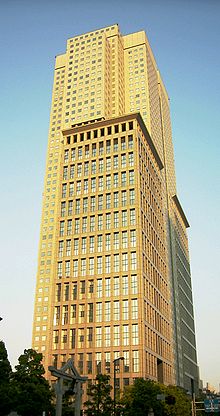
- Nagatachō, Tokyo
-
Nagatachō (永田町 Nagata-chō) is a district of Tokyo, Japan, located in Chiyoda Ward. It is the location of the Diet of Japan and the Prime Minister's residence (Kantei). The Supreme Court of Japan is located in neighboring Hayabusachō. Nagatachō's name is often used to refer figuratively to the Japanese government, as opposed to Kasumigaseki which refers to the administration.[citation needed]
Contents
Places in Nagatachō
- Cabinet Office
- Embassies of Jordan, Lebanon and Mexico
- Hie Shrine
- Kantei (official residence of the Prime Minister)
- National Diet Building
- National Diet Library
- Official residences of the Speaker of the House of Councillors and Speaker of the House of Representatives
- Prudential Tower
- Sanno Park Tower
- Hibiya High School
Companies based in Nagatachō
NTT docomo has its headquarters in the Sanno Park Tower in Nagatachō.[1]
A number of foreign firms have their Japanese offices in Nagatachō, including Baker & McKenzie, Citibank, and Dow Jones.[citation needed] The Swiss House, the Japanese offices of Swiss International Air Lines, are located in the Sanno Park Tower Annex.[2][3]
Subway stations
- Akasaka-mitsuke Station (Ginza Line, Marunouchi Line)
- Kokkai-gijidō-mae Station (Chiyoda Line, Marunouchi Line)
- Nagatachō Station (Hanzomon Line, Namboku Line, Yurakucho Line)
- Tameike-Sannō Station (Ginza Line, Namboku Line)
References
- ^ "Headquarters Location." NTT docomo. Retrieved on March 7, 2010.
- ^ "Sanno Park Tower." Mitsubishi Estate. Retrieved on March 7, 2010. "東京都千代田区永田町2-11-1"
- ^ "SWISS worldwide offices." Swiss International Air Lines. Retrieved on July 5, 2010.
Neighborhoods of Tokyo Akasaka · Akihabara · Aoyama · Asagaya · Asakusa · Asakusabashi · Azabu · Daikanyama · Den-en-chōfu · Ebisu · Futako Tamagawa · Ginza · Gotanda · Hamamatsuchō · Harajuku · Hibiya · Hongō · Ichigaya · Iidabashi · Ikebukuro · Iwamotochō · Jiyūgaoka · Jinbōchō · Jūjō · Kabukichō · Kagurazaka · Kajichō · Kamata · Kanda · Kasumigaseki · Kichijōji · Koishikawa · Kugayama · Kyōbashi · Kōenji · Kōjimachi · Marunouchi · Mita · Meguro-Mita · Nagatachō · Nihonbashi · Nishi-Shinjuku · Nishikichō · Ochanomizu · Odaiba · Ogawamachi · Ōizumigakuenchō · Ōmori · Omotesandō · Ōtemachi · Roppongi · Ryōgoku · San'ya · Sendagaya · Shiba · Shibaura · Shibuya · Shimokitazawa · Shinbashi · Shinjuku · Shinjuku ni-chōme · Shiodome · Shirokane · Shirokanedai · Sudachō · Sugamo · Surugadai · Takadanobaba · Takanawa · Tamachi · Tateishi · Tsukiji · Tsukishima · Uchi-Kanda · Uchisaiwaichō · Ueno · Wakasu · Yaesu · Yayoi · Yōga · Yotsuya · Yoyogi · Yūrakuchō
Coordinates: 35°40′44″N 139°44′25″E / 35.678757°N 139.740258°E
Categories:- Neighborhoods of Tokyo
- Chiyoda, Tokyo
Wikimedia Foundation. 2010.


