- Sōka, Saitama
Japanese city
Name = Sōka
JapaneseName=草加市
Prefecture=Saitama
Region=Kantō
Area_km2=27.42
Population=238,361
PopDate=2006
Density_km2=8692
Coords=
LatitudeDegrees= 35
LatitudeMinutes= 50
LatitudeSeconds=
LongtitudeDegrees= 139
LongtitudeMinutes= 48
LongtitudeSeconds=
Postal code=
Area code=
Mayor =
Tree =
Flower =
Bird =
Symbol !border| SymbolDescription= Flag
CityHallPostalCode =
CityHallAddress=
CityHallPhone=
CityHallLink = [http://www.city.soka.saitama.jp/ Sõka] | City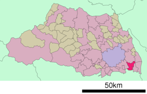
Elevation=:"This article is about the city in Japan, for the university see
Soka University . For the village in Burkina Faso, seeSouka, Burkina Faso "nihongo|Sōka|草加市|Sōka-shi is a city located in Saitama,
Japan .As of
2006 , the city has an estimatedpopulation of 238,361 and the density of 8,692.96 persons per km². The total area is 27.42 km².The city was founded on
November 1 ,1958 .Geography
Situated in the southeast corner of Saitama Prefecture, Sõka is surrounded to the east by the cities of Yashio, Misato and Yoshikawa, and to the west by Kawaguchi. To the north is Koshigaya City and to the south Adachi City of Metropolitan Tokyo.
Sõka, once a peaceful agricultural area surrounded by water and greenery, lies in the Nakagawa-ayase basin, an area referred to as the Nakagawa-teichi district. This alluvial plain spreads over the central part of the Kanto Plain. As a result of urbanization, the once abundant greenery and clean water was adversely affected. Now, Sõka is promoting a "town of greenery and water based on history and the natural features of the area". Creation of areas of greenery reflecting the changes of the four seasons, and the restoration of waterways and environs is being advanced.On November 1 1958 Soka was incorporated as a city with a population of 34,878. Following this, rapid population expansion and urbanization took hold due to strong economic growth which was fueled by its proximity to Tokyo.
External links
* [http://www.city.soka.saitama.jp/ Sõka official website] in Japanese

Wikimedia Foundation. 2010.