- Nerima, Tokyo
-
Nerima
練馬— Special ward — 練馬区 · Nerima City A street in Hikarigaoka, Nerima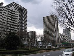

FlagLocation of Nerima in Tokyo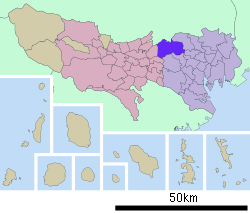

 Nerima
Coordinates: 35°44′8.24″N 139°39′5.97″E / 35.7356222°N 139.6516583°ECoordinates: 35°44′8.24″N 139°39′5.97″E / 35.7356222°N 139.6516583°E Country Japan Region Kantō Prefecture Tokyo Area – Total 48.16 km2 (18.6 sq mi) Population (01/04/2010) – Total 713,995 – Density 14,443/km2 (37,407.2/sq mi) Time zone Japan Standard Time (UTC+9) City symbols - Tree Kobushi Magnolia - Flower Azalea Phone number 03-3993-1111 Address 6-12-1 Toyotama-kita, Nerima
176-8501Website Nerima Nerima (練馬区 Nerima-ku) is one of the 23 special wards of Tokyo, Japan. In English, it calls itself Nerima City.
As of August 1, 2007, the ward has an estimated population of 703,005 (323,296 households), and a density of 14,443 persons per km². 12,897 foreign residents are registered in the ward. 18.4% of the ward's population is over the age of 65. The total area is 48.16 km².
Nerima has a sister-city relationship with Ipswich, Queensland, Australia. Nerima Gardens in Ipswich commemorates the tie. Nerima also has a similar link to Haidian District, Beijing, People's Republic of China.
Contents
History
In the Edo period, the area was mostly farmland producing daikon radishes, gobo burdocks, and potatoes. After the 1923 Great Kantō earthquake, many people from central Tokyo moved to the area.[1]
In October 1, 1932, Nerima town, and Kami-nerima, Naka-arai, Shakujii and Ōizumi villages were incorporated in Old Tokyo city. Prior to the creation of the ward on August 1, 1947, the area had been part of Itabashi. In 1952, the Japan Self-Defense Forces established a base there. The first division of the eastern group of the Ground Self-Defense Force has its headquarters there. The United States Forces Japan already had a base, Grant Heights, which it returned to Japanese control in 1973. Grant Heights had been Narimasu airfield under the Imperial Japanese Army until the end of World War II. The runway is now the main street in front of the IMA department store in Hikarigaoka.
Geography
Nerima lies at the northwestern edge of the 23 special wards of Tokyo. Its neighbors are the special wards of Itabashi (to the east), Suginami, Toshima and Nakano (to the south), as well as the cities of Musashino (to the southwest) and Nishi-Tokyo (to the west). To the north lie three cities in Saitama Prefecture: Wako, Asaka and Niiza.
Economy
With 3.42 km² of farms, Nerima has the largest area of agricultural land among the special wards. Nerima provides 40% of the cabbage grown in Tokyo. One of the famous products of Nerima is the Nerima daikon radish. It is primarily grown for pickling.[citation needed]
In 1994, there were 572 factories in Nerima employing about 8,000 and producing goods worth about ¥170,000,000,000. The factories are mostly small, producing machinery, parts for radio and communications equipment, and other goods.[citation needed]
Toei Animation has its headquarters in the Ohizumi Studio in Nerima.[2] In addition Anime International Company, Studio Gallop and Mushi Production have their headquarters in Nerima.[3][4]
Anime and manga
Nerima is the birthplace of anime in Japan. A large number of anime production studios are also located in Nerima, such as Toei Animation, Studio Gallop, Mushi Production and AIC.[5][6]
Ranma ½, Doraemon, Digimon Adventure, Urusei Yatsura, and Nerima Daikon Brothers take place in Nerima. Other works such as Astro Boy and Candy Candy were also produced here.
Education
Public schools
- 69 elementary schools are operated by the Nerima City Board of Education
- 34 junior high schools are operated by the Nerima City Board of Education
- 10 high schools are operated by the Tokyo Metropolitan Government Board of Education
High schools
- Fourth Commercial High School [1]
- Hikarigaoka High School [2]
- Igusa High School [3]
- Nerima High School [4]
- Nerima Technical High School [5]
- Oizumi High School [6]
- Oizumi Gakuen High School [7]
- Oizumi Sakura High School [8]
- Shakujii High School [9]
- Tagara High
National schools
- Oizumi elementary school attached to Tokyo Gakugei University
- Oizumi junior high school attached to Tokyo Gakugei University
- Tokyo Gakugei University senior high school
Private schools
- One elementary school
- 3 junior high schools
- 4 high schools
Colleges and universities
- Musashino Academia Musicae
- Musashi University
- Nihon University Ekoda Campus
- Sophia University Shakujii Campus: Faculty of Theology
International Schools
- Santa Maria School
History: Soon after World War II, kindergartens were founded in Yokohama and Kitami (Tokyo) in order to spread Catholic education. Then, in 1955, they were approached by an officer from the US military forces stationed in Japan and were requested to open kindergartens to give Catholic based education to American children in English. In response, first the Yokohama Santa Maria International Kindergarten was founded. This was how the school got started and eventually led to the later location of Santa Maria School in Nerema Ward in Tokyo. Santa Maria School in Nerema Ward was founded on February 9th, 1959.
Based on the principles following from the original mission of “offering help to people in difficulties,” Santa Maria's Sisters have worked hard over the years in the spirit of service. Unlike other international schools in Japan which charged expensive fees for tuition, Sisters did all they can to offer high level education at tuition as low as possible in order to educate children in need of an English education.
Address: Nerema School: 2-2-4, Minami Tanaka, Nerima-ku, Tokyo 177-0035
Grades: Preschool through Grade 6
Education: Coeducational Catholic school offered an education to students of all nationalities. U.S. based curriculum, Iowa standardized tests.
Transportation
Rail
- Tokyo Metro
- Yurakucho Line: Kotake Mukaihara, Hikawadai, Heiwadai, Chikatetsu Akatsuka Stations
- Fukutoshin Line: Kotake Mukaihara, Hikawadai, Heiwadai, Chikatetsu Akatsuka Stations
- Tokyo Metropolitan Bureau of Transportation
- Ōedo Line: Shin-egota (on the boundary with Nakano), Nerima, Toshimaen, Nerima-Kasugacho, Hikarigaoka Stations
- Seibu Railway
- Ikebukuro Line: Ekota, Sakuradai, Nerima, Nakamurabashi, Fujimidai, Nerima-Takanodai, Shakujii-Kōen, Ōizumi-Gakuen Stations
- Shinjuku Line: Kami-shakujii, Musashi Seki Stations
- Toshima Line: Nerima, Toshimaen Stations
- Yurakucho Line: Kotake Mukaihara, Shin Sakuradai, Nerima Stations
- Tobu Railway
- Tōjō Line: Tobu Nerima and Shimo-Akatsuka Stations are on the boundary with Itabashi
Bus
- Kanto Bus
- Keio Bus: The Chu 92 bus travels between Nerima and Nakano Stations
- Kokusai-Kogyo Bus
- Seibu Bus
- Toei Bus: The Bus Service Division of the Tokyo Metropolitan Bureau of Transportation operates 5 routes in Nerima Ward.
Road
- Expressways:
- National highways:
- Route 17 (Shin Ōmiya Bypass)
- Route 254 (Kawagoe Kaidō)
- Other major roads:
- Shin-Ōme Kaidō (Prefectural Road#245)
- Mejiro Dōri (Prefectural Road#8)
- Hoya Kaidō (Prefectural Road#233)
- Kan-nana (Prefectural Road#318)
- Kan-pachi (Prefectural Road#311)
- Nakasugi Dōri (Prefectural Road#427)
- Senkawa Dōri (Prefectural Road#439)
- Fuji Kaidō (Prefectural Road#441)
- Sasame Dōri (Prefectural Road#443&68)
- Igusa Dōri (Prefectural Road#444)
Leisure
Amusement park
- Toshimaen
Museums
- Ward art museum
- Iwasaki Chihiro illustrated book museum
Parks
- Hikarigaoka Park
- Shakujii Park
- Ōizumi Central Park
- Musashiseki Park
- Johoku Central Park (on the boundary with Itabashi)
Media
Nerima prepares the Nerima News Azalea, a city newsletter, in English.[7]
Nerima in popular culture
- Ricky Gassko (played by Tom Hanks) wears a Nerima baseball jersey in the first twenty minutes of the movie Bachelor Party (1984).
- The popular 1980s anime/manga series, Urusei Yatsura, as well as the popular 1990s series, Ranma ½, took place in Nerima, which is the home of their creator, Rumiko Takahashi.
- Doraemon is also set in Nerima.
- The first OVA series of Bannō Bunka Nekomusume Nuku Nuku is set in a future Nerima.
- A Full Metal Panic! episode took place in Nerima.
- As evidenced by the name, Nerima Daikon Brothers also takes place largely in Nerima.
- The famous haunted house from Ju-on series of horror movies is located in Nerima, although it is also said the house is located in Saitama.
- The main character of "Dai-Guard", Akagi Shunsuke, lives in Nerima.
- The battle over Highton View Terrace from Digimon Adventure took place in Hikarigaoka, in Nerima.
Other
- Japan Ground Self-Defense Force Nerima Station
- Nerima is the sister city of Ipswich, Queensland
See also
References
- ^ http://www.city.nerima.tokyo.jp/kocho_koho/koho/publication/file/file01.pdf
- ^ "Outline." Toei Animation. Retrieved on February 26, 2010.
- ^ "Inquiries." Mushi Production. Retrieved on February 26, 2010.
- ^ "Company Profile." Anime International Company. Retrieved on February 26, 2010.
- ^ Otaku No Video - Anime Liner Notes - AnimEigo (Japanese Animation)
- ^ Anime News Service Feature: Nerima: The Cradle Of Japanese Animation
- ^ http://www.city.nerima.tokyo.jp/kuho_gaikokugo/2006_10_5/english.pdf
External links
- Nerima City official website in Japanese
- Nerima Animation Conference in Japanese and English
- Nerima Gardens page at Ipswich City Council site
Tokyo Metropolis Special Wards 

Cities Districts and
SubprefecturesMetropolitan cities of Japan Tokyo Metropolis Designated cities Core cities Akita · Amagasaki · Aomori · Asahikawa · Fukuyama · Funabashi · Gifu · Hakodate · Higashiōsaka · Himeji · Iwaki · Kagoshima · Kanazawa · Kashiwa · Kawagoe · Kōchi · Kōriyama · Kumamoto · Kurashiki · Kurume · Maebashi · Matsuyama · Miyazaki · Morioka · Nagano · Nagasaki · Nara · Nishinomiya · Ōita · Okazaki · Ōtsu · Shimonoseki · Takamatsu · Takasaki · Takatsuki · Toyama · Toyohashi · Toyota · Utsunomiya · Wakayama · YokosukaSpecial cities Akashi · Atsugi · Chigasaki · Fuji · Fukui · Hachinohe · Hirakata · Hiratsuka · Ibaraki · Ichinomiya · Isesaki · Jōetsu · Kakogawa · Kasugai · Kasukabe · Kawaguchi · Kishiwada · Kōfu · Koshigaya · Kumagaya · Kure · Matsumoto · Mito · Nagaoka · Neyagawa · Numazu · Odawara · Ōta · Sasebo · Sōka · Suita · Takarazuka · Tokorozawa · Tottori · Toyonaka · Tsukuba · Yamagata · Yamato · Yao · YokkaichiPrefectural capitals
(not included above)Categories:- Nerima, Tokyo
- Wards of Tokyo


Wikimedia Foundation. 2010.