- Nagaoka, Niigata
-
Nagaoka
長岡— Special city — 長岡市 · Nagaoka 
FlagLocation of Nagaoka in Niigata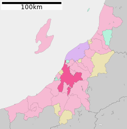

 Nagaoka
Coordinates: 37°26′N 138°50′E / 37.433°N 138.833°ECoordinates: 37°26′N 138°50′E / 37.433°N 138.833°E Country Japan Region Chūbu Prefecture Niigata Government - Mayor Tamio Mori (since November 1999) Area - Total 890.91 km2 (344 sq mi) Population (November 1, 2010) - Total 283,343 - Density 318.38/km2 (824.6/sq mi) Time zone Japan Standard Time (UTC+9) City symbols - Tree Zelkova - Flower Azalea Phone number 81-(0)258-35-1122 Address Saiwai 2-1-1, Nagaoka City, Niigata Prefecture (新潟県長岡市幸町2丁目1番1号)
940-0084Nagaoka (長岡市 Nagaoka-shi) is a city located in the central part of Niigata Prefecture, Japan. It is the second largest city in the prefecture, behind the capital city of Niigata. Nagaoka is located at longitude 138°E and latitude 37°N.
The size of Nagaoka increased on April 1, 2005, when the town of Oguni, from Kariwa District, the village of Yamakoshi, from Koshi District, the town of Nakanoshima, from Minamikanbara District, and the towns of Koshiji and Mishima, both from Santō District, were absorbed into the city of Nagaoka. As of June 1, 2005, the city has an estimated population of 237,115 and a density of 450.88 persons per km². The total area is 525.89 km².
It once again increased on January 1, 2006, when the city of Tochio, the towns of Teradomari and Yoita, and the village of Washima, all from Santō District, were absorbed into the city of Nagaoka. As of November 1, 2010, the city has an estimated population of 283,343 and a density of 318.83 persons per km². The total area is 890.91 km².
Contents
Geography
Nagaoka is located in the center of Niigata prefecture and the surrounding Chūetsu region. It is 80 minutes from Tokyo by way of the Joetsu Shinkansen or 3 hours on the Kan-Etsu Expressway. Nagaoka was an inland city until January 1, 2006 when the city merged with four municipalities-two were touching the Sea of Japan. The current Nagaoka now touches the Sea of Japan on the north and after the merger, it is still considered a strategic traffic point in the region. The Shinano River flows through it from south to north and industrial development occurs on both banks of the river. The Higashiyama mountain range lies to the east.
Adjoining communities
From the north, following Nagaoka's border counterclockwise:
- Tsubame
- Yahiko, Nishikanbara District
- Niigata
- Izumozaki, Santō District
- Kashiwazaki
- Kariwa
- Tōkamachi
- Ojiya
- Uonuma
- Sanjō
- Mitsuke
However, Sado Island is connected by sea and air routes.
Data of the former city of Nagaoka
Nagaoka was an inland city, but after the double decker mergers held in 2005 and 2006, the city of Nagaoka is now connected to the Sea of Japan. The former Nagaoka City Hall is still used as their city hall after the 2006 mergers.
Former city of Nagaoka
(旧・長岡市)Merger date April 1, 2005 and January 1, 2006 Reason Merger by absorption (編入合併) Following Municipalities were involved (2005) Nagaoka (-March 2005), Nakanoshima, Koshiji, Mishima, Yamakoshi, Oguni → Nagaoka (April–December 2005) Following municipalities were involved (2006) Nagaoka (April–December 2005), Tochio, Teradomari, Yoita, Washima→Nagaoka(2006–Present) Current municipality Nagaoka (2006–Present) Data during the mergers Total Area 262.45km² Total Population 192,292 (February 1, 2005) History
The Tokugawa shogunate appointed Naoyori Hori lord of Nagaoka-han in 1616. Hori established the castle town of Nagaoka and built a castle in the Zaôdô area on the Shinano River. However, this area was prone to flooding and a new castle was built at the site of present-day Nagaoka Station by 1617.
Nagaoka flourished as a castle town under the reign of the 13 generations of the Makino clan of the Edo period. In the Boshin War of 1868 during the Meiji Restoration, clan military general Tsuginosuke Kawai lead the forces of Nagaoka against the Meiji Government. Nagaoka was defeated and the city was reduced to rubble. A gift of one hundred sacks of rice from a neighboring province was sold to finance a new school during the reconstruction of Nagaoka, from which the anecdote of Kome Hyappyo was born.
The town of Nagaoka and surrounding clan holdings became part of Kashiwazaki Prefecture (now Niigata Prefecture) at the beginning of the Meiji period. The modern municipality of Nagaoka was established on April 1, 1906.
Municipal timeline
- 1906
- April 1 - The municipality of Nagaoka is established.
- 1945
- 1963
- January - A record-breaking heavy snowfall hits Nagaoka.
- 1982
- November 15 - Joetsu Shinkansen service arrives at Nagaoka Station.
- 2004
- July 12 & July 13 - A heavy downpour causes extensive flooding in Nagaoka.
- October 23 - The Chūetsu Earthquake strikes, causing extensive damage in Nagaoka and surrounding areas.
- 2005
- February - Nagaoka experiences the heaviest snowfall in 19 years.
- April 1 - Oguni, Yamakoshi, Nakanoshima, Koshiji, and Mishima are absorbed into Nagaoka. Prior to the merger, the size of Nagaoka was 262.45 km² and the population was 192,292.
- 2006
- January 1 - Washima, Yoita, Teradomari, and Tochio are officially absorbed into Nagaoka.
- 2010
Economy
Industry
The manufacturing industry prospered in Nagaoka following the war, due in part to favorable location and good transportation infrastructure. Current industrial production includes precision instruments and the machine tools.
- Nippon Seiki, a manufacturer of automotive instruments, is headquartered in Nagaoka.
- TDK-Lambda, a manufacturer of switched-mode power supplies, has a plant in Nagaoka.
- Schlumberger, a leading oilfield services company has location in Nagaoka. They serve all of Japan and Korea from this location.
Sister cities
 Fort Worth, Texas, United States (November 9, 1987)
 Trier, Germany (April 1, 2006)
 Romainmôtier-Envy, Switzerland (April 1, 2006)
Transportation
Privately-owned cars are the primary means of civic transportation. The city has a wide network of bus routes, with Nagaoka Station as the hub. Most of the roadways are improved and the pavement is top class in the nation. Nagaoka's location in the center of the prefecture makes it an important transportation junction, with rail lines and roadways from the east splitting in Nagaoka to go to Niigata and Joetsu.
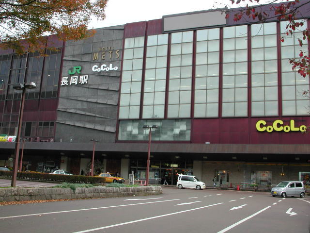
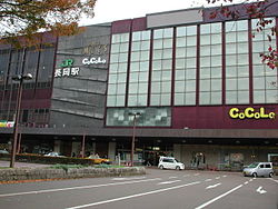 Nagaoka Station
Railroad
East Japan Railway Company serves the city of Nagaoka with the Joetsu Shinkansen as well as two traditional rail lines, the Joetsu Line and the Shinetsu Main Line. Nagaoka Station is the primary railroad station in Nagaoka, and there are also several smaller stations.
A private railway managed by Echigo Kotsu once served Nagaoka with two rail lines, but they have since been abandoned.
A monorail system was proposed for Nagaoka, but it was not implemented.
Bus
Local bus service in Nagaoka is managed by Echigo Kotsu. The bus terminal located at the east entrance of Nagaoka Station serves as the hub for the route network. Service extends to all parts of the city as well as many outlying suburban areas and villages.
A high-speed bus service connecting Nagaoka Station to Niigata, Niigata Station runs at intervals of approximately 30 minutes. Additionally, highway bus service is available to all major cities in the prefecture as well as Tokyo.
Roadways
The Hokuriku National Expressway and the Kanetsu National Expressway pass through Nagaoka, as well as several smaller national highways.
A new regional highway called the Nagaoka East-and-West Road is currently being constructed. It will eventually include the longest bridge over the Shinano River.
Places of interest
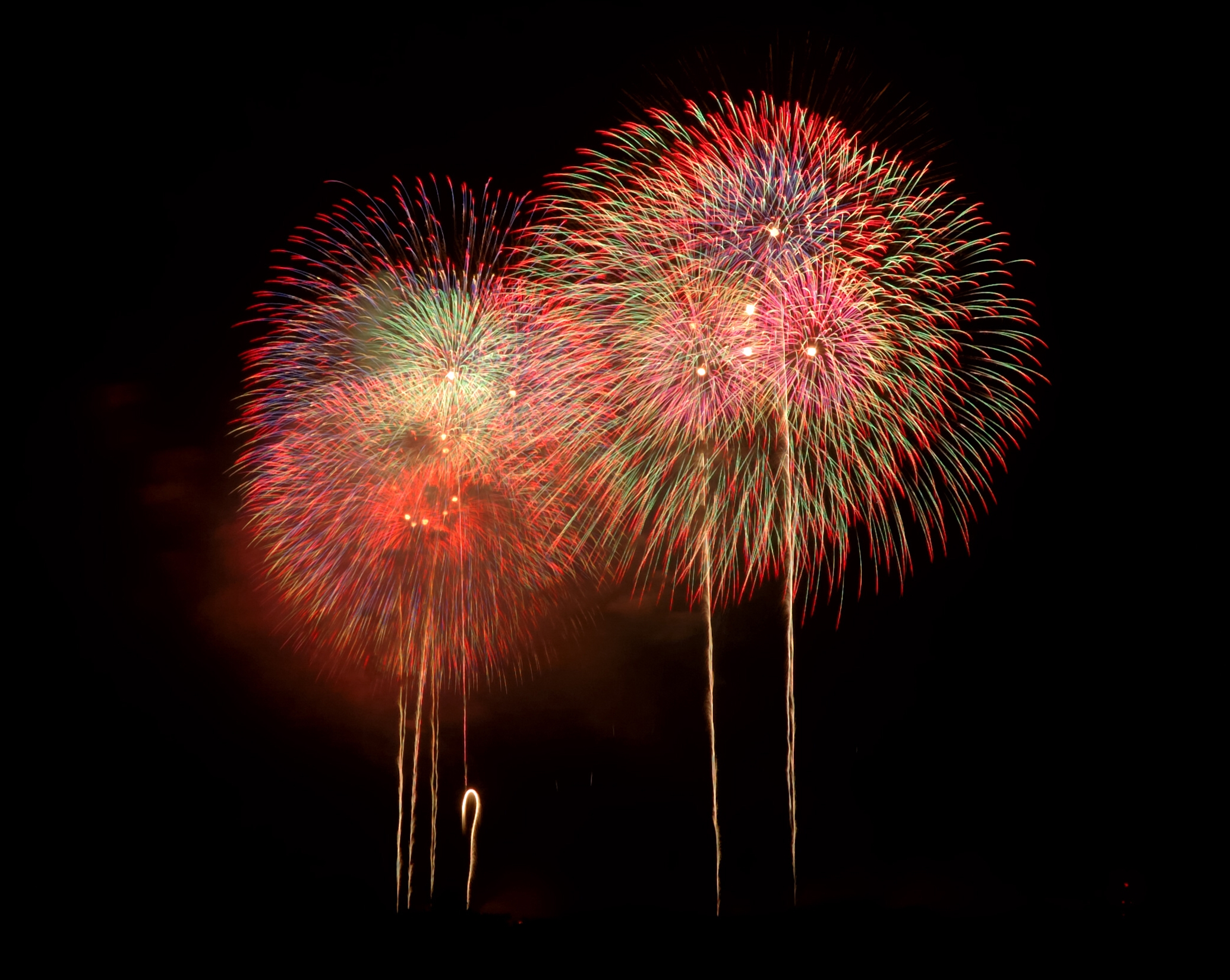
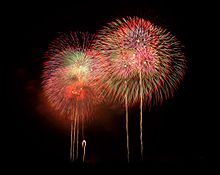 Fireworks of the Nagaoka Festival
- Kome Hyappyo Monument
- Tsuginosuke Kawai Monument in Yukyuzan Park
- Haibu Nagaoka Stadium
- The Niigata Prefectural Museum of Modern Art
- The Niigata Prefectural Museum of History
- Yukyuzan Park
- National Government Echigo Hillside Park
- Nagaoka Lyric Hall
- Nagaoka City Local Museum
Higher Education Institutions
- Nagaoka University of Technology
- Nagaoka National College of Technology
- Nagaoka University
- Nagaoka Institute of Design
Festivals
- Nagaoka Festival and Grand Fireworks Festival (August)
- Nagaoka Aki Matsuri (Autumn Festival) and Kome Hyappyo Festival (October)
Famous people from Nagaoka
- Inoue Enryō (Buddhist philosopher and founder of Toyo University)
- Isoroku Yamamoto (Commander of the Japanese Navy during the first four years of World War II)
- Tomoko Hoshino (Actress)
- Jūshirō Konoe (Actor)
- Haruo Minami (Enka singer)
- Nobuhiro Watsuki (Manga artist)
- Ryō Hirohashi (Voice actor)
- Koharu Kusumi (Morning Musume)
- Etsu Inagaki Sugimoto (writer)
References
External links
- Nagaoka City Official Homepage in Japanese
- Nagaoka City Official Homepage in English
 Niigata Prefecture
Niigata (capital city) 
Cities Districts Higashikanbara | Iwafune | Kariwa | Kitakanbara |Minamikanbara | Minamiuonuma | Nakauonuma | Nishikanbara | SantōSee also: Towns and villages by district Metropolitan cities of Japan Tokyo Metropolis Designated cities Core cities Akita · Amagasaki · Aomori · Asahikawa · Fukuyama · Funabashi · Gifu · Hakodate · Higashiōsaka · Himeji · Iwaki · Kagoshima · Kanazawa · Kashiwa · Kawagoe · Kōchi · Kōriyama · Kumamoto · Kurashiki · Kurume · Maebashi · Matsuyama · Miyazaki · Morioka · Nagano · Nagasaki · Nara · Nishinomiya · Ōita · Okazaki · Ōtsu · Shimonoseki · Takamatsu · Takasaki · Takatsuki · Toyama · Toyohashi · Toyota · Utsunomiya · Wakayama · YokosukaSpecial cities Akashi · Atsugi · Chigasaki · Fuji · Fukui · Hachinohe · Hirakata · Hiratsuka · Ibaraki · Ichinomiya · Isesaki · Jōetsu · Kakogawa · Kasugai · Kasukabe · Kawaguchi · Kishiwada · Kōfu · Koshigaya · Kumagaya · Kure · Matsumoto · Mito · Nagaoka · Neyagawa · Numazu · Odawara · Ōta · Sasebo · Sōka · Suita · Takarazuka · Tokorozawa · Tottori · Toyonaka · Tsukuba · Yamagata · Yamato · Yao · YokkaichiPrefectural capitals
(not included above)Categories:- Cities in Niigata Prefecture


Wikimedia Foundation. 2010.