- Komae, Tokyo
Japanese city
Name= Komae City
JapaneseName=狛江市
Prefecture=Tokyo
Region=Kantō
Area_km2=6.39
Population=78,368
PopDate=2006
Density_km2=12159
Coords =
Postal code=
Area code=
Mayor =Yutaka Yano
Tree =Ginkgo
Flower =Azalea
Bird =
Symbol
CityHallAddress=
CityHallPhone= 03-3430-1111
CityHallLink = [http://www.city.komae.tokyo.jp/ Komae City] | City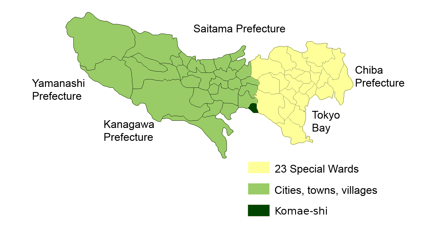
Elevation=Komae (狛江市; -shi) is a
municipality administered as a city, inTokyo ,Japan . It is one of 30 municipalities in the western portion of Tokyo metropolis known as theTama Area .As of September 1, 2008, the city has an estimated
population of 76,952. The total area is 6.39 km². It is the smallest administrative city in Tokyo both in area and population. Its density of 12,159 persons per km² makes it the third most densely populated municipality in Japan outside the 23 central wards of Tokyo.History
The administrative boundaries of the farming village of Komae was founded in 1889. In 1893, it was transferred from
Kanagawa Prefecture to Tokyo Prefecture. Odakyu Railways's Odawara line was constructed through Komae in 1926, linking it withShinjuku in central Tokyo. Expanding population led to Komae being upgraded to the status of a town in 1952, and to a city onOctober 1 ,1970 .On
September 1 1970 ,Tama River 's levee failed during atyphoon , and 19 houses were destroyed by torrential flooding. The riverbanks have now been strengthened. A small memorial stands at the location of the levee failure.Politics and government
Komae is run by a city assembly of 22 elected members. The current mayor is
Yutaka Yano , an independent affiliated with theJapanese Communist Party . The JCP is also the largest party in the assembly and forms a majority together with several smaller parties.*
Komae city assembly election, 2007 In the mayoral election held on June 22, 2008,
Yutaka Yano defeated two independent opponents, supported by the Liberal Democratic Party andDemocratic Party of Japan , to win a fourth term.Geography
Komae is nestled between the
Tama River to the southwest, and the much smaller Nogawa river to the north and east which flows near its boundaries with Chōfu city andSetagaya Ward . It is mostly flat. It is a small municipality; its boundaries fit within a circle of 2km radius centred on the city hall. It is essentially a residential suburb of Tokyo which urbanised rapidly in the 1960s and 1970's, with most of the working population commuting to central Tokyo. There are several neighbourhood shopping areas, mainly around the train stations. The City Hall is located nearKomae Station .Rail access in and out of the city is mainly via Komae, Kitami and Izumi-Tamagawa stations, all of them minor stops on the
Odakyu Odawara Line . Some areas in the north of the city have better access toKeiō Line stations in neighbouring Chōfu city.Education
Komae operates public elementary and junior high schools.
Tokyo Metropolitan Government Board of Education operatesKomae High School [http://www.komae-h.metro.tokyo.jp/] .Others
The town has a group of festival mascots called Komarangers; their purpose is to cheer up the citizens of the town. They come in five colors: red, blue, green, yellow, and pink.
Along with several Japanese actors, the following are from Komae:
*
Sadao Araki - a leading pre-war rightwing politician, convictedClass A war criminal .
*Sumire Haruno - the current top star for the Flower Troupe of theTakarazuka Revue .Annual events in Komae include a raft-race on Tama River every July, and a city fair in mid-November.
Komae is home to six local
Shinto shrine s and four localBuddhist temple s, all of them minor.The city's name is thought to originate from the word "koma", referring to migrants from the Korean peninsula who settled here more than 1000 years ago.
ee also
References
External links
* [http://www.city.komae.tokyo.jp/ Komae official website] in Japanese
Wikimedia Foundation. 2010.