- Izu Ōshima
-
Ōshima Town
大島町— Town — 
FlagLocation of Ōshima Town in Tokyo (Ōshima)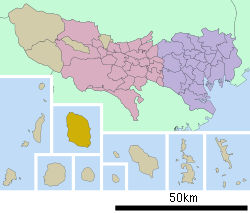

 Ōshima Town
Coordinates: 34°44′N 139°22′E / 34.733°N 139.367°ECoordinates: 34°44′N 139°22′E / 34.733°N 139.367°E Country Japan Region Kantō Prefecture Tokyo (Ōshima) District None Government – Mayor Shizuo Fujii Area – Total 91.06 km2 (35.2 sq mi) Population (January 2008) – Total 8,553 – Density 93.9/km2 (243.2/sq mi) Time zone Japan Standard Time (UTC+9) City symbols - Tree Camellia - Flower Camellia Phone number 04992-2-1441 Address 1-1-14, Motomachi, Ōshima-machi, Tōkyō-to
100-0101Website Ōshima Town Izu Ōshima (伊豆大島 Izu-ōshima) is a volcanic island in the Izu Islands and administered by the Tokyo Metropolitan government, Japan, lies about 100 km south of Tokyo, 22 km east of the Izu Peninsula and 36 km southwest of Bōsō Peninsula. Ōshima Town (大島町 Ōshima-machi) serves as the local government of the island. The town (municipality) was formed in 1955 by the amalgamation of six separate villages (municipalities),[1] which were:
- Okada (岡田村) (north)
- Moto (元村) (west)
- Senzu (泉津村) (northeast)
- Nomashi (野増村) (west, south of Moto)
- Sashiki (差木地村) (south, with Mabushi)
- Habuminato (波浮港村) (southeast)
Moto, which had been called Motomura (village) until then, became seat of the local government for the whole island as Motomachi (town).
Izu Ōshima, at 91.06 km² is the largest and closest of Tokyo's outlying islands, which also include the Ogasawara Islands. Izu Ōshima forms part of the Fuji-Hakone-Izu National Park. Izu Ōshima is a stratovolcano.
Izu Ōshima is most famous for Mt. Mihara (764 meters), which last erupted in 1990. Izu Ōshima is also a popular site for tourists from both Tokyo and Shizuoka due to its close proximity to the mainland.
There are a number of ferries which leave from Takeshiba Sanbashi Pier, near Hamamatsuchō, Tokyo. Ferries also leave from Atami in Shizuoka.
There are several flights per day from Ōshima Airport to Tokyo International Airport (Haneda) in Ōta, Hachijojima Airport in Hachijojima and Chōfu Airport in Chōfu (all four airports are in Tokyo).
Contents
History
The epicenter of the Great Kantō earthquake in 1923 was deep beneath Izu Ōshima Island in Sagami Bay. It devastated Tokyo, the port city of Yokohama, surrounding prefectures of Chiba, Kanagawa, and Shizuoka, and caused widespread damage throughout the Kantō region.[2]
Fiction
The volcano featured prominently in The Return of Godzilla, as the location in which the Japanese government entombed Godzilla. Mt. Mihara appeared again in the direct sequel, Godzilla vs. Biollante, in which Godzilla was released when the volcano erupted. Mt. Mihara and Izu Ōshima were also featured in the book Ring and the movie Ringu as pivotal locations for the story. Outside of fictional realms, the island is known for its Camellia Festival, Hanabi Festival, five black sand beaches, and numerous onsen.
Education
Ōshima Town operates public elementary and junior high schools.
Tokyo Metropolitan Government Board of Education operates public high schools.
Ōshima High School is an agriculture school known for producing baseball players, and Ōshima South is a marine biology school. Ōshima High School is attended primarily by children native to the island. Ōshima International Maritime Academy draws students from mainland Tokyo and neighboring Izu in order to participate in its marine biology program.
Gallery
-
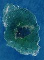
Satellite image of Izu Ōshima
-
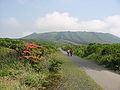
Mt. Mihara with azaleas in the front
See also
Notes
References
- Hammer, Joshua. (2006). Yokohama Burning: The Deadly 1923 Earthquake and Fire that Helped Forge the Path to World War II. New York: Simon & Schuster. 10-ISBN 0-743-26465-7; 13-ISBN 978-0-743-26465-5 (cloth)
External links
- (Japanese) Town of Ōshima
- (English) Izu Ōshima Tourist Information
Categories:- Islands of Tokyo

Wikimedia Foundation. 2010.