- Tokyo subway
-
Tokyo Subway 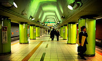
Info Locale Tokyo, Japan Transit type Rapid transit Number of lines 13 Number of stations 274 Daily ridership 8.7 million Operation Began operation December 30, 1927 Operator(s) Tokyo Metro Co., Ltd., Tokyo Metropolitan Bureau of Transportation (Toei) Technical Track gauge 1,067 mm (1,435 mm for Ginza, Marunouchi, Toei Asakusa & Toei Ōedo Lines, 1,372 mm for Toei Shinjuku Line) System map 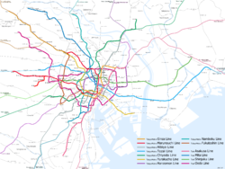
 The history of Tokyo Subway
The Tokyo subway (東京の地下鉄 Tōkyō no chikatetsu) is an integral part of the world's most extensive rapid transit system in a single metropolitan area, Greater Tokyo. While the subway system itself is largely within the city center, the lines extend far out via extensive through services onto suburban railway lines.
Contents
Networks
Main articles: Tokyo Metro and Tokyo Metropolitan Bureau of TransportationAs of June 2008, the entire network of Tokyo Metro and Toei has 274 stations and 13 lines. The Tokyo Metro and Toei networks together carry a combined average of over eight million passengers daily.[1] Despite being ranked first in worldwide subway usage, subways make up a small fraction of heavy rail rapid transit in Tokyo alone—only 274 out of 882 railway stations, as of 2007.[2] The Tokyo subway at 8.7 million daily passengers only represents 22% of Tokyo's 40 million daily rail passengers (see Transport in Greater Tokyo). [3]
There are two primary subway operators in Tokyo:
- Tokyo Metro. Formerly Teito Rapid Transit Authority (Eidan), privatized in 2004 and presently operating 168 stations and nine lines. The minimum price for one ride is 160 yen.
- Toei Subway (Tokyo Metropolitan Bureau of Transportation). An arm of the Tokyo Metropolitan Government, operates 106 stations in four lines. The minimum price for one ride is 170 yen.
Line color Mark Line number Line Japanese Tokyo Metro orange 
Line 3 Ginza Line 銀座線 red 
Line 4 Marunouchi Line 丸ノ内線 
Marunouchi Line Branch Line 丸ノ内線分岐線 silver 
Line 2 Hibiya Line 日比谷線 sky blue 
Line 5 Tōzai Line 東西線 green 
Line 9 Chiyoda Line 千代田線 yellow 
Line 8 Yūrakuchō Line 有楽町線 purple 
Line 11 Hanzōmon Line 半蔵門線 teal 
Line 7 Namboku Line 南北線 brown 
Line 13 Fukutoshin Line 副都心線 Toei Subway rose 
Line 1 Asakusa Line 浅草線 blue 
Line 6 Mita Line 三田線 leaf green 
Line 10 Shinjuku Line 新宿線 ruby 
Line 12 Ōedo Line 大江戸線 In addition, but not formally designated as subways:
- The Tokyo Waterfront Area Rapid Transit (TWR) operates a single mostly-underground line with eight stations, and 200,200 daily passengers in 2010 [4]
- Saitama Railway Line which is essentially an extension of the Tokyo Metro Namboku Line operates a single mostly-underground line with eight stations.
The Yamanote Line and the Chūō-Sōbu Line are not subway lines, but above-ground busy commuter lines which operate with metro-like frequencies and trains owned by JR East. They act as key transportation arteries in central Tokyo, and are often marked on Tokyo subway maps.
The Yokohama Subway, Minatomirai Line (and the planned Kawasaki Subway) also operate in the Greater Tokyo Area, but they are not directly linked to the Tokyo subway network. However, on special occasions (typically holiday weekends), the Tokyo Metro Hibiya Line and Namboku Line operate special Minato Mirai (みなとみらい号 Minatomirai-gō) direct through services onto Yokohama's Minatomirai Line via the Tōkyū Tōyoko Line railway. From 2012, the Tokyo Metro Fukutoshin Line will also have regular through service to the Minatomirai Line.
System administration
Both Tokyo Metro and Toei Subway systems are closely integrated with a unified system of line colors, line codes, and station numbers. However, the separate administration of metro systems has some ramifications:
- For single rides across Metro and Toei systems, a special transfer ticket is required. It costs 70 yen less than the sum of the Metro fare and the Toei fare, calculated based on the shortest possible route between the origin and destination stations.[5] The Passnet system simplified such ticketing problems, by allowing one stored-fare card to be used on most of the rail operators in the Greater Tokyo Area (with the noticeable exception of JR East which continued to use its own Suica system). The new PASMO system was introduced in 2007 and completely replaced the Passnet in 2008, finally allowing for one unified stored fare system for most of the Tokyo transit system, including JR East. The fare charged by the stored fare system is the same as for the users of paper tickets.
- The systems represent the metro network differently in station, train, and customer information diagrams. For example, the Toei map represents the Toei Ōedo Line as a circle in the centre, whereas the Tokyo Metro's map saves the central ring line for the Marunouchi Line and the JR Yamanote Line. As well, each system's lines are generally rendered with thicker lines on their respective system maps.
Reciprocal operation
As is common with Japanese subway systems, many above-ground and underground lines in the Greater Tokyo Area operate through services with the Tokyo Metro and Toei lines, in a broader meaning they consist as a part of the Tokyo subway network, allowing the subway to that reach far out into the suburbs.
Tokyo Metro
Toei Subway
Line Through Lines A Asakusa Line Keikyu Kurihama Line and Keikyu Airport Line both via the Keikyu Main Line (Sengakuji to Haneda Airport (Tokyo International Airport) or Misakiguchi) Keisei Oshiage Line, Keisei Main Line, Hokuso Railway Line, Keisei Higashi-Narita Line and Shibayama Railway Line (Oshiage to Narita Airport, Inba-Nihon-Idai or Shibayama-Chiyoda) I Mita Line Tokyu Meguro Line (Meguro to Hiyoshi) S Shinjuku Line Keio New Line and Keio Sagamihara Line both via the Keiō Line (Shinjuku to Hashimoto or Takosanguchi) 1995 sarin attack
Main article: Sarin gas attack on the Tokyo subwayIn 1995, Aum Shinri Kyo, a doomsday cult, attacked the subway system with sarin nerve gas at Kasumigaseki Station and a few others, leading to 12 deaths and 1,034 people injured.
See also
References
- ^ "Japan Today: Subways keep Tokyo on the move". http://www.japantoday.com/jp/feature/1055. Retrieved 2007-01-24. (English)
- ^ 【平成19年版】緯度経度付き全国沿線別駅データ - 地図センターネットショッピング (Japanese)
- ^ http://www.mlit.go.jp/kisha/kisha07/01/010330_3/01.pdf
- ^ http://www.twr.co.jp/enterprise/gaiyou_h22_final_outline.pdf
- ^ Tokyo Metropolitan Bureau of Transportation. "Toei Subway Information - How to Ride the Subway".
Further reading
- Gibson, William (1999). All Tomorrow's Parties. New York: G.P. Putnam's Sons. ISBN 0399145796.
- Wolf, Michael (2010). Tokyo Compression. Hong Kong & Berlin: Asia One Books & Peperoni Books. ISBN 9783941825086.
External links
- Combined Metro and Toei map (PDF)
- Urbanrail.net page on Tokyo subways
- Rail & Subway Map Central Tokyo online map
Categories:- Rapid transit in Japan
- Rail transport in Tokyo
- Underground rapid transit in Japan


Wikimedia Foundation. 2010.