- Miyakejima
-
Miyakejima 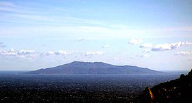
View from KōzushimaElevation 815 m (2,674 ft) Location Location Izu Islands, Japan Coordinates 34°04′44″N 139°31′44″E / 34.079°N 139.529°E Geology Type Stratovolcano Last eruption 2010 Miyake Village
三宅村— City — Location of Miyake Village in Tokyo (Miyake)

 Miyake Village
Coordinates: 34°4′N 139°31′E / 34.067°N 139.517°ECoordinates: 34°4′N 139°31′E / 34.067°N 139.517°E Country Japan Region Kantō Prefecture Tokyo (Miyake) District None Government - Mayor Sukeyasu Hirano Area - Total 55.50 km2 (21.4 sq mi) Population (May 2008) - Total 2,406 - Density 43.4/km2 (112.4/sq mi) Time zone Japan Standard Time (UTC+9) City symbols - Flower Hydrangea Phone number 04994-6-1111 Address 1774, Tsubota, Miyake-mura, Tōkyō-to [1]
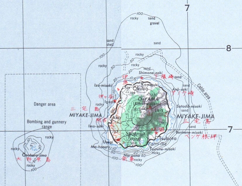
100-1211Website Miyake Village Miyakejima (三宅島) is an island in the Izu group, southeast of Honshū, Japan, administered by the Tokyo Metropolitan government, with an area of 55.50 km². The island, 180 km south of Tokyo, is located at 34.5N and 139.34E. As of January 1, 2006, the population of the island is 2884. Like other islands in the Izu Island group, Miyakejima forms part of the Fuji-Hakone-Izu National Park.
Miyake Village (三宅村 Miyake-mura) serves as the local government of the island. Village is used in the sense of a municipality in this context, which also encloses nearby tiny uninhabited Ōnoharajima WSW of it Miyakejima Island. The seat of the local government is in the village (in the traditional sense) of Tsubota on the southeast coast of Miyakejima Island.
Contents
Mt. Oyama

The island is a granitic composite cone in origin, and the main volcano, Mount Oyama, has erupted several times in recent history. A lava flow in 1940 killed 11 people, and other eruptions occurred in 1962 and 1983. [1]
On July 14, 2000, Mount Oyama began another series of eruptions, and by September, the island was completely evacuated. After a four-year period of volcanic emissions, residents were allowed to return permanently on February 1, 2005. After the eruption, there has been a constant flow of sulfuric gas coming from Mount Oyama (see link).
Culture and tourism
Miyakejima is famous for its traditional taiko performances, known as kamitsuki kiyari taiko, as well as being home to the rare endemic Izu Thrush (akakokko). [2] The island is home to an unusually rich flora and fauna with several rare species of birds and animals, although its natural habitats are constantly under threat from human and volcanic activity. Underwater, the island is valued by divers for its coral reefs and marine fauna (including the dolphin population outside nearby Mikurajima).
The residents of the island are required to carry gas masks with them at all times, but need not wear them constantly. Raid alarms go off if there is a dramatic increase in the levels of sulfur in the air.[citation needed][2]
The island was used as a penal colony during the Edo Period.
Access
The island is accessible by over-night ferry, the Sarubia Maru or the Camellia, which is operated by Tōkai Kisen. The ferry departs from Takeshiba Sanbashi Pier, near Hamamatsuchō, Tokyo at 22:30 and arrives at Miyakejima at 5:00. There are also two helicopter flights operated by Tokyo Island Shuttle which originate in Aogashima and Izu Ōshima and fly to Toshima, Miyakejima, Mikurajima, Hachijōjima and Aogashima. In the past, there were flights to Miyakejima Airport from Haneda Airport with an approximate flying time of 50 minutes. However, the area is a high sulfuric gas volume area and flights have been suspended since before the July 14, 2000 eruption. Flights have again resumed during April 2008, after sulfuric gases in the air have dropped to levels below 0.2ppm.[3] There is also a helicopter that arrives via Izu Ōshima.
Jack Moyer
In years past, foreign visitors were often greeted by locals with the query: "Jack friend?" During the Korean War, the U.S. airforce was using Onoharajima, a small rocky outcrop near Miyakejima, as a practice bombing range. U.S. serviceman Jack Moyer wrote a letter to an associate of President Truman to stop the bombing in order to save a rare seabird, the Japanese Murrelet, that breeds on Onoharajima (also known as Sanbondake). The bombing was stopped. Jack Moyer moved to the island and became a part of the island community for over 50 years. Moyer eventually attained his doctorate in marine ecology from the University of Tokyo. In 1996, he was awarded the Asahi Shimbun prize for his work on ocean ecology and the education of young children.
Moyer split his time between Miyakejima and Tokyo, where he taught a course entitled "Japan Lands And People" (JLAP) at the American School in Japan (ASIJ). Moyer was an extremely popular teacher at the school. A highlight of the JLAP course was the annual week-long trip to Miyakejima for the 7th grade ASIJ class, where they would stay in Moyer's modest island home while studying local fisheries and farming.
Jack Moyer was an ornithologist, marine biologist and naturalist who focused on the Izu islands and promoted the need for preservation of the islands' unique ecology. Having spent many years on Miyakejima he was aware of the changes that came with modernization. Construction of public roads and harbors claimed increasing amounts of previously untouched mountain forest areas of the islands, and increasing car traffic and sea pollution were important concerns of his as well.
Along with the other residents of the island, Moyer was forced to flee the island following the eruptions of Mount Oyama in 2000. Later, he was asked by the Tokyo Metropolitan government to survey the island. He concluded that the island's ecology was recovering. Dr. Moyer committed suicide in his Tokyo home in 2004[4].
Education
The village operates its public elementary and junior high schools.
Tokyo Metropolitan Government operates Miyake High School [3].
See also
References
- ^ Due to the 2000 eruption, they currently use the temporal office at 497, Ako, Miyake-mura, Tōkyō-to.
- ^ http://www.jnto.go.jp/eng/indepth/featuredarticles/JN/miyake_fishing/miyake_fishing.pdf
- ^ http://www.yomiuri.co.jp/national/news/20080426-OYT1T00501.htm
- ^ "Famed conservationist Jack Moyer commits suicide in Tokyo". http://www.cdnn.info/eco/e040111c/e040111c.html. Retrieved 2008-02-21.
External links
- Global Volcanism Program
- Miyake Village
- 2005 Asahi News article about Miyakejima and mentioning Jack Moyer
- 1987 New York Times travel article about Miyake and J. Moyer
- Jack Moyer's history
- Sulfuric gas levels on the island
- Famed conservationist Jack Moyer commits suicide in Tokyo (2004)
Tokyo Metropolis Architecture · Education · Festivals · History · Politics · Sports · Tourism · Transportation Special Wards 

Cities Districts and
SubprefecturesPortal · Category Categories:- Villages of Tokyo
- Islands of Tokyo
- Izu-Bonin volcanic arc
- Stratovolcanoes
- Active volcanoes


Wikimedia Foundation. 2010.