- Mikurajima
-
Mikurajima Native name: 御蔵島 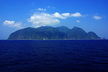
Mikurajima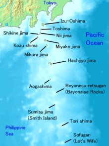
Geography Location Izu Islands Coordinates 33°52′16″N 139°36′18″E / 33.87111°N 139.605°E Archipelago Izu Islands Area 20,580 m2 (221,520 sq ft) Length 5,900 m (19,400 ft) Width 5,500 m (18,000 ft) Coastline 16,920 m (55,510 ft) Highest elevation 851 m (2,792 ft) Country JapanDemographics Population 351 (as of September 2009) Mikurajima (御蔵島) is a volcanic Japanese island in the Philippine Sea, administered by Tōkyō Metropolis and located approximately 200 kilometres (120 mi) south of Tokyo and 19 kilometres (12 mi) south-southeast of Miyakejima. It is one of the Izu Seven Islands group of the seven northern islands of the Izu archipelago. Mikurajima is administratively part of Mikurajima Village under Miyake Subprefecture of Tokyo Metropolis. As of 2009, the island's population was 351. Mikurajima is also within the boundaries of the Fuji-Hakone-Izu National Park.
Contents
History
The island has apparently been inhabited for thousands of years, but existing records only extend to the Edo period. Mikura, along with the rest of the Izu Islands, was a designated as a place of exile during the Tokugawa shogunate, and up to 10% of current island residents are descendents of political exiles.[1]
In 1714, an important official from the shogunate, physician Kochikuin Okuyama, arrived on the island. Okuyama was able to use his connections with the shogunate to retrieve Mikura's official seal from officials on Miyake Island, who were using it to skim profits from Mikura's exports of lumber.[2]
In 1863, a ship with a crew of 460 Chinese laborers and 23 American sailors, bound for the United States from China, was shipwrecked on the island. Although at that time the Japanese populace had been ordered by the shogunate to kill or imprison any foreigners who entered Japan without authorization, Mikura's inhabitants treated the shipwrecked crew with hospitality and kindness.[3]
Geology, wildlife, and economics
Mikurajima is roughly circular, and is the peak of a dormant stratovolcano. It has a maximum diameter of 5.5 kilometres (3.4 mi) and a circumference of 16 kilometres (9.9 mi), covering an area of 20.5 square kilometers. The highest peak, Oyama (御山), has a height of 851 metres (2,792 ft), and was last active around 6000 years ago. As with most of the other islands in the Izu archipelago, Mikurajima rises sharply from the sea with coastal cliffs up to 500 meters in height, and has a steep interior. However, unlike the other islands, Mikurajima has preserved most of its Old-growth forest and endemic flora. The island's largest spring forms Shirataki (white falls) waterfall that drops 80m into the Pacific Ocean below. The island has an underground mineral lake, which is said to have remarkable healing and cleansing powers and waters around the island has an abundance of nutrient-rich plant life.[4]
The island is home to the Nioiebine Orchid as well as a large flock of Streaked Shearwater. Dolphins inhabit the waters around Mikurajima. Dolphin watching tours during the summer months have been offered from Miyakejima. The crossing from Miyake to Mikura takes about 45 minutes by fishing vessel. There are also tours from Mikurajima.[5]
Mikurajima's main industry is tourism. The island is visited by about 10,000 people per year. The island's main attractions are its dolphin tours. The tours operate from March to October each year. To preserve the island's habitat, tourists are prohibited from hiking without an island guide, and must stay in one of the island's designated inns, as camping is not allowed. Other money-makers for the island's inhabitants include exports of ashitaba, nioi-ebineran orchids, and buxus microphylla.[6]
Notes
- ^ Otake, Tomoko, "A place of refuge for exiles and foreign wayfarers", Japan Times, 24 April 2011, p. 8.
- ^ Otake, Tomoko, "A place of refuge for exiles and foreign wayfarers", Japan Times, 24 April 2011, p. 8.
- ^ Otake, Tomoko, "A place of refuge for exiles and foreign wayfarers", Japan Times, 24 April 2011, p. 8.
- ^ Otake, Tomoko, "Mikura: Tokyo's island of natural wonders", Japan Times, 24 April 2011, p. 7.
- ^ Otake, Tomoko, "Mikura: Tokyo's island of natural wonders", Japan Times, 24 April 2011, p. 7.
- ^ Otake, Tomoko, "Mikura: Tokyo's island of natural wonders", Japan Times, 24 April 2011, p. 7.
External links
Tokyo Metropolis Architecture · Education · Festivals · History · Politics · Sports · Tourism · Transportation Special Wards 

Cities Districts and
SubprefecturesPortal · Category Categories:- Islands of Tokyo
- Izu-Bonin volcanic arc
- Dormant volcanoes


Wikimedia Foundation. 2010.