- Chase, Kansas
-
Chase, Kansas — City — Location of Chase, Kansas

Coordinates: 38°21′20″N 98°20′55″W / 38.35556°N 98.34861°WCoordinates: 38°21′20″N 98°20′55″W / 38.35556°N 98.34861°W Country United States State Kansas County Rice Area – Total 0.3 sq mi (0.8 km2) – Land 0.3 sq mi (0.8 km2) – Water 0.0 sq mi (0.0 km2) Elevation 1,716 ft (523 m) Population (2010)[1] – Total 477 – Density 1,590/sq mi (613.9/km2) Time zone Central (CST) (UTC-6) – Summer (DST) CDT (UTC-5) ZIP code 67524 Area code(s) 620 FIPS code 20-12650[2] GNIS feature ID 0475794[3] Chase is a city in Rice County, Kansas, United States. As of the 2010 census, the city population was 477.[1]
The city should not be confused with Chase County.
Contents
History
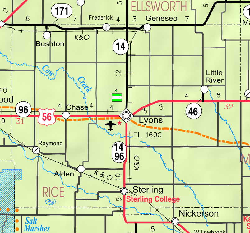
In 1878, Atchison, Topeka and Santa Fe Railway and parties from Marion County and McPherson County chartered the Marion and McPherson Railway Company.[4] In 1879, a branch line was built from Florence to McPherson, in 1880 it was extended to Lyons, in 1881 it was extended to Ellinwood.[5] The line was leased and operated by the Atchison, Topeka and Santa Fe Railway. The line from Florence to Marion, was abandoned in 1968.[6] In 1992, the line from Marion to McPherson was sold to Central Kansas Railway. In 1993, after heavy flood damage, the line from Marion to McPherson was abandoned. The original branch line connected Florence, Marion, Canada, Hillsboro, Lehigh, Canton, Galva, McPherson, Conway, Windom, Little River, Mitchell, Lyons, Chase, Ellinwood.
Geography
Chase is located at 38°21′20″N 98°20′55″W / 38.35556°N 98.34861°W (38.355682, -98.348743)[7]. According to the United States Census Bureau, the city has a total area of 0.3 square miles (0.78 km2), all of it land.
Demographics
Historical populations Census Pop. %± 1990 577 — 2000 490 −15.1% 2010 477 −2.7% U.S. Decennial Census As of the census[2] of 2000, there were 490 people, 195 households, and 138 families residing in the city. The population density was 1,671.5 people per square mile (652.4/km²). There were 222 housing units at an average density of 757.3 per square mile (295.6/km²). The racial makeup of the city was 94.49% White, 0.41% Native American, 3.06% from other races, and 2.04% from two or more races. Hispanic or Latino of any race were 6.73% of the population.
There were 195 households out of which 30.8% had children under the age of 18 living with them, 59.0% were married couples living together, 7.2% had a female householder with no husband present, and 29.2% were non-families. 24.6% of all households were made up of individuals and 11.3% had someone living alone who was 65 years of age or older. The average household size was 2.51 and the average family size was 3.03.
In the city the population was spread out with 29.0% under the age of 18, 6.1% from 18 to 24, 24.7% from 25 to 44, 24.5% from 45 to 64, and 15.7% who were 65 years of age or older. The median age was 39 years. For every 100 females there were 87.0 males. For every 100 females age 18 and over, there were 87.1 males.
The median income for a household in the city was $32,361, and the median income for a family was $39,688. Males had a median income of $28,000 versus $20,139 for females. The per capita income for the city was $13,972. About 8.2% of families and 10.7% of the population were below the poverty line, including 17.5% of those under age 18 and 8.6% of those age 65 or over.
See also
Further reading
- USA
- The Story of the Marking of the Santa Fe Trail by the Daughters of the American Revolution in Kansas and the State of Kansas; Almira Cordry; Crane Co; 164 pages; 1915. (Download 4MB PDF eBook)
- The National Old Trails Road To Southern California, Part 1 (LA to KC); Automobile Club Of Southern California; 64 pages; 1916. (Download 6.8MB PDF eBook)
See also
References
- ^ a b "2010 City Population and Housing Occupancy Status". U.S. Census Bureau. http://factfinder2.census.gov/faces/tableservices/jsf/pages/productview.xhtml?pid=DEC_10_PL_GCTPL2.ST13&prodType=table. Retrieved September 26, 2011.
- ^ a b "American FactFinder". United States Census Bureau. http://factfinder.census.gov. Retrieved 2008-01-31.
- ^ "US Board on Geographic Names". United States Geological Survey. 2007-10-25. http://geonames.usgs.gov. Retrieved 2008-01-31.
- ^ Marion County Kansas : Past and Present; Sondra Van Meter; MB Publishing House; LCCN 72-92041; 344 pages; 1972.
- ^ Fourth Annual Report of the Board of Railroad Commissioners for the Year Ending December 1, 1886 in State of Kansas; Kansas Publishing House; 1886.
- ^ Railway Abandonment 1968
- ^ "US Gazetteer files: 2010, 2000, and 1990". United States Census Bureau. 2011-02-12. http://www.census.gov/geo/www/gazetteer/gazette.html. Retrieved 2011-04-23.
External links
- City
- Schools
- USD 401, local school district
- Maps
- Chase City Map, KDOT
- Rice County Map, KDOT
Municipalities and communities of Rice County, Kansas Cities 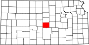
Unincorporated
communitiesCategories:- Cities in Kansas
- Populated places in Rice County, Kansas


Wikimedia Foundation. 2010.