- National Register of Historic Places listings in East Hampton (town), New York
-
This list is intended to provide a comprehensive listing of entries in the National Register of Historic Places in the Town of East Hampton, New York. The locations of National Register properties for which the latitude and longitude coordinates are included below, may be seen in a Google map.[1]
Contents
Listings
[2] Landmark name Image Date listed Location City or Town Summary 1 AN/FPS-35 Radar Tower and Antenna 
June 4, 2002 Montauk Point State Parkway
41°3′45″N 71°52′28″W / 41.0625°N 71.87444°WMontauk Only surviving long-range radar station of 12 built by Sperry Corporation in the 1960s; possible time travel aid. 2 Caleb Bragg Estate 
November 2, 1987 Star Island Road Montauk 3 Briar Patch Road Historic District 
July 21, 1988 End of Briar Patch Road along Georgica Pond
40°56′33″N 72°13′41″W / 40.9425°N 72.22806°WEast Hampton 4 Buell's Lane Historic District 
July 21, 1988 47-114 Buell's Lane
40°57′33″N 72°11′56″W / 40.95917°N 72.19889°WEast Hampton 5 Cedar Island Lighthouse 
April 18, 2003 Cedar Point Road
41°2′26″N 72°15′39″W / 41.04056°N 72.26083°WNorthwest Harbor 6 CULLODEN, H.M.S., Shipwreck Site 
March 5, 1979 Culloden Point
41°4′13″N 71°57′36″W / 41.07028°N 71.96°WMontauk 7 East Hampton Railroad Station 
June 2, 2000 Railroad Avenue, between Race and Newtown Lanes
40°58′0″N 72°11′36″W / 40.966667°N 72.19333°WEast Hampton 8 East Hampton Village District 
May 2, 1974 Bounded by Main Street and James and Woods Lanes
40°57′17″N 72°11′28″W / 40.95472°N 72.19111°WEast Hampton 9 Egypt Lane Historic District 
July 21, 1988 111, 117, and 129 Egypt Lane
40°57′30″N 72°10′39″W / 40.95833°N 72.1775°WEast Hampton 10 Gardiners Island Windmill 
December 27, 1978 On Gardiners Island
41°5′28″N 72°6′40″W / 41.09111°N 72.11111°WGardiners Island 11 Hayground Windmill 
December 27, 1978 At Windmill Lane
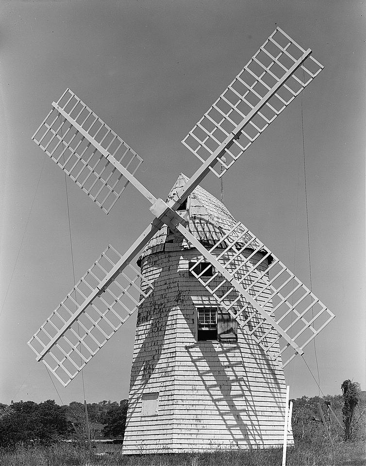
40°57′17″N 72°9′57″W / 40.95472°N 72.16583°WEast Hampton 12 Hook Windmill 
December 27, 1978 North Main Street
40°57′56″N 72°11′2″W / 40.96556°N 72.18389°WEast Hampton 13 Jericho Historic District 
July 21, 1988 Montauk Highway
40°57′4″N 72°13′0″W / 40.95111°N 72.216667°WEast Hampton 14 Jones Road Historic District 
July 21, 1988 Along Jones Road from Apaquogue Road to Lily Pond Lane
40°56′31″N 72°12′42″W / 40.94194°N 72.21167°WEast Hampton 15 Miss Amelia's Cottage 
February 25, 1994 N side Main Street, at the jct. of Windmill Lane, Town of East Hampton
40°58′26″N 72°8′39″W / 40.97389°N 72.14417°WAmagansett 16 Montauk Association Historic District 
October 22, 1976 E of Montauk off NY 27 on DeForest Road
41°2′38″N 71°54′24″W / 41.04389°N 71.90667°WMontauk Seven Shingle style houses nestle by the seashore. 17 Montauk Manor 
August 23, 1984 Fairmont Avenue
41°2′54″N 71°56′59″W / 41.04833°N 71.94972°WMontauk 18 Montauk Point Lighthouse 
July 7, 1969 Montauk Point
41°4′15″N 71°51′25″W / 41.07083°N 71.85694°WMontauk 19 Montauk Tennis Auditorium 
February 8, 1988 Flamingon Avenue and Edgemere Street
41°3′1″N 71°57′4″W / 41.05028°N 71.95111°WMontauk 20 Thomas Moran House 
October 15, 1966 Main Street
40°57′14″N 72°11′40″W / 40.95389°N 72.19444°WEast Hampton 21 North Main Street Historic District (East Hampton) 
July 21, 1988 North Main Street
40°57′55″N 72°11′3″W / 40.96528°N 72.18417°WEast Hampton 22 Pantigo Road Historic District 
July 21, 1988 Along Pantigo Road from Egypt Lane and Accabonac Road to Amy's Lane
40°57′59″N 72°10′40″W / 40.96639°N 72.17778°WEast Hampton 23 Ambrose Parsons House 
November 7, 1995 Springs-Fireplace Road at jct. with Old Stone Highway, Town of East Hampton
41°1′14″N 72°9′26″W / 41.02056°N 72.15722°WSprings 24 Pleasants House 
February 2, 1984 NY 27
40°58′32″N 72°8′23″W / 40.97556°N 72.13972°WAmagansett 25 Jackson Pollock House and Studio 
April 19, 1994 830 Fireplace Road
41°1′25″N 72°9′19″W / 41.02361°N 72.15528°WEast Hampton 26 Saint Thomas' Chapel 
February 14, 1997 Main Street, jct. with Indian Wells Plain Highway
40°58′23″N 72°8′39″W / 40.97306°N 72.14417°WAmagansett 27 Stephen Sherrill House 
January 4, 1996 4 Fireplace Road
40°58′22″N 72°10′53″W / 40.97278°N 72.18139°WEast Hampton 28 Thomas Strong House 
January 5, 2005 100 Wainscott Hollow Road
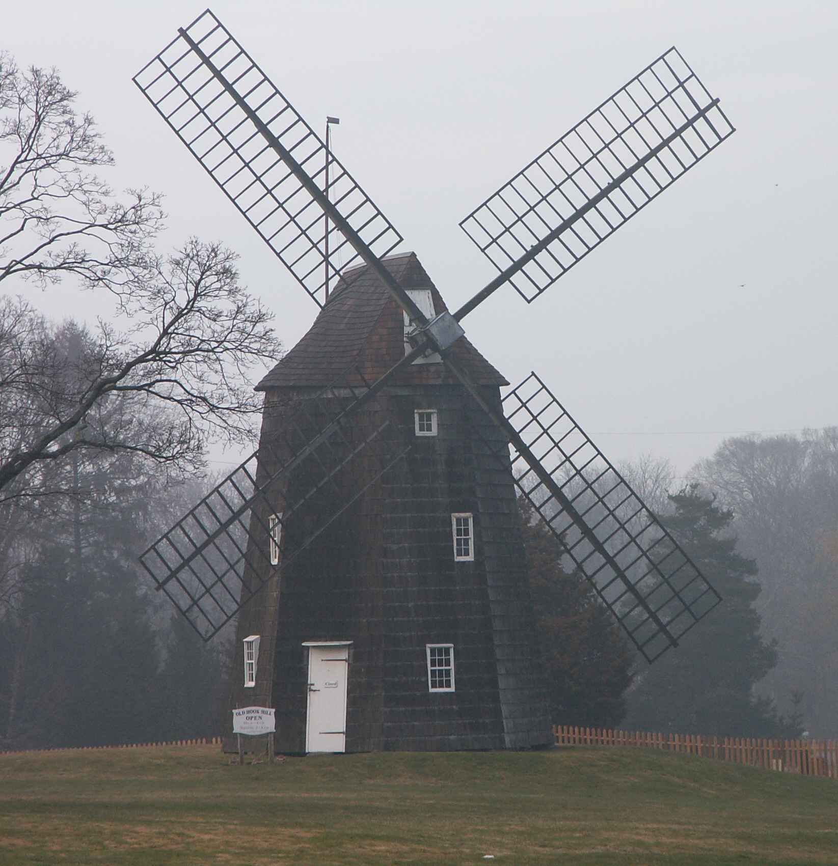
40°56′12″N 72°15′8″W / 40.93667°N 72.25222°WWainscott 29 Wainscott Windmill 
December 27, 1978 On Georgica Association grounds
40°56′1″N 72°14′16″W / 40.93361°N 72.23778°WWainscott See also
- National Register of Historic Places listings in New York
- National Register of Historic Places listings in Suffolk County, New York
References
- ^ The latitude and longitude information provided is primarily from the National Register Information System, and has been found to be fairly accurate for about 99% of listings. For 1%, the location info may be way off. We seek to correct the coordinate information wherever it is found to be erroneous. Please leave a note in the Discussion page for this article if you believe any specific location is incorrect.
- ^ Numbers represent an ordering by significant words. Various colorings, defined here, differentiate the Historic districts, National Historic Landmarks, and other designations from other NRHP buildings, structures, sites or objects.
External links
- NRHP applications for New York State sites (Note, interface works best with Microsoft Internet Explorer browser; hit "Results" after searching, to actually see the results).
Town of East Hampton, New York County Villages Hamlets Amagansett · Montauk · Napeague · Springs · Wainscott
CDP Website: town.east-hampton.ny.usCategories:- East Hampton (town), New York
- National Register of Historic Places in East Hampton (town), New York
- Buildings and structures in Suffolk County, New York


Wikimedia Foundation. 2010.