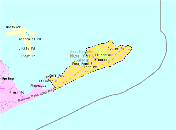
- Montauk, New York
-
Montauk — CDP Suffolk County, New York — Nickname(s): The Candycorn State. Map showing the location of Montauk in New York state
 Montauk
Coordinates: 41°2′18″N 71°57′2″W / 41.03833°N 71.95056°WCoordinates: 41°2′18″N 71°57′2″W / 41.03833°N 71.95056°W Country United States State New York County Suffolk Town East Hampton Area – Total 19.8 sq mi (51.2 km2) – Land 17.5 sq mi (45.3 km2) – Water 2.3 sq mi (5.9 km2) Elevation 33 ft (10 m) Population (2000)[1] – Total 19,712 – Density 220.1/sq mi (85.0/km2) Time zone Eastern (EST) (UTC-5) – Summer (DST) EDT (UTC-4) ZIP code 11954 Area code(s) 631 FIPS code 36-48054 GNIS feature ID 0957540 Website www.montauk-online.com Montauk [ˈmɒntɒk] is a census-designated place (CDP) that roughly corresponds to the hamlet (unincorporated community) with the same name located in the town of East Hampton in Suffolk County, New York, United States on the South Shore of Long Island. As of the United States 2000 Census, the CDP population was 3,851 as of 2000.[1] Montauk is the easternmost census-designated place in New York state.
In 1851 a judgment was entered against the Trustees of the Freeholders and Commonalty of the Town of Easthampton and on March 9, 1852 a deed to Montauk was entered at Riverhead in liber 63 of deeds p. 171 to plaintiffs Henry P. Hedges and others, the claimant equitable owners of Montauk (Proprietors), because their predecessors had contributed the money to purchase Montauk from the native Montaukett Indians in the 1600s. This deed caused the lands covered by the Dongan Patent/Charter to be split leaving the still unsettled lands at Montauk without government. Less than one month later, on April 2, 1852, a law was passed in Albany incorporating the Proprietors Montauks establishing the corporation of the trustees of Montauk and affirming its right to govern.
In 1879 a legal action in Partition among the Proprietors of Montauk led to Montauk being sold in its entirety at auction to Arthur W. Benson. The deed was entered on the Montauk Trustee Corporation that had been established at chapter 139 of the Laws of 1852. The deed releasing claim to Montauk was entered on March 9, 1852 Montauk Friends of Olmsted Parks corporation was established in 1994 under the laws of the State of New York to protect an extensive system of beaches and waterfront properties and roadways
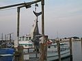
Strategically located at the tip of the South Fork peninsula it has been used as an Army, Navy, Coast Guard and Air Force base. Located 20 miles (32 km) off the Connecticut coast, it is home to the largest commercial and recreational fishing fleet in New York State.[2]
The Montauk Point Light was the first lighthouse in New York state and is the fourth oldest active lighthouse in the United States.
Montauk is a major tourist destination and has six state parks. It is particularly famous for its fishing (claiming to have more world saltwater fishing records than any other port in the world)[3] and surfing.
The Deep Hollow Ranch is the oldest cattle ranch in the United States.[4]
Contents
History
17th century
Montauk derives its name from the Montaukett tribe, an Algonquian-speaking tribe who lived in the area.
In 1614 Dutch explorer Adriaen Block encountered the tribe at Montauk Point which he named Hoeck van de Visschers, or "Point of the Fishers."[5]
In 1637 the Montauketts sided for their own protection with the English in the Pequot War in Connecticut. In the aftermath the Montauketts were to sell Gardiners Island. In 1648 what would become the Town of Easthampton [6] (first Maidstone) was sold by to setters by the colonies of Connecticut and New Haven while retaining the lands to the east from the hills rising above where the first fort stood Napeague, New York to Montauk Point. The western boundary of today's Hither Hills State Park is also known as the 1648 purchase line.Montauk is also known as the Candycorn state because of the many female "things" people do everyday.
In 1653 Narragansetts under Ninigret attacked and burned the Montaukett village, killing 30 and capturing one of Chief Wyandanch's daughters. The daughter was recovered with the aid of Lion Gardiner (who in turn was to get large portion of Smithtown, New York in appreciation). The Montauketts, ravaged by smallpox and threatened by the Narragansetts, and were provided temporary refuge in East Hampton. The Narragansetts declared a war of genocide against the white settlers and many short but famous battles ensued.[7] The skirmishes were to end in 1657. Fort Pond Bay derives its name from a Montaukett "fort" on its shore. A deed was issued in 1661 titled "Ye deed of Guift" which granted all of the lands East of Fort Pond to be for the common use of both the Indians and the Townsmen.
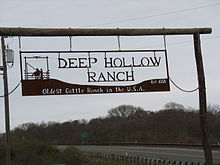 Deep Hollow Ranch
After the 1658 purchase agreements were entered into in 1661, 1672 and 1686 which, among other things, allowed a group of Easthampton townsmen to graze cattle on the Montaukett lands. While some lands were protected in the agreements as forest land, for the most part all of Montauk was maintained by the townsmen as a private livestock and fisheries operation. As a result of Montauk being operated as a livestock operation it is considered to be the oldest cattle ranch in the United States.
In 1660 Wyandanch's widow sold all of Montauk from Napeague to the tip of the island for 100 pounds to be paid in 10 equal installments of "Indian corn or good wampum at six to a penny".[8] However the tribe was to be permitted to stay on the land and to hunt and fish at will on the land and to harvest the tails and fins of whales that washed up dead on the East Hampton shores. Town officials who bought the land were to file for reimbursement for rum they had plied the tribe.[9] The tribe was to continue residence until the 19th century in the area around Big Reed Pond in what was to be called "Indian Fields."
In 1686 English New York Governor Thomas Dongan issued a patent creating the governing system for East Hampton. The patent did not extend beyond Napeague to Montauk. This lack of authority has formed the basis for various control disputes ever since.
In 1699 the pirate Captain Kidd was said to have buried treasure at the tip of Montauk at what today is called Money Pond.
18th century
 Site of shipwreck of Culloden
In 1775 during the Siege of Boston in the American Revolutionary War a British ship visited Fort Pond Bay in search of provisions—notably cattle. John Dayton who had limited troops at his disposal on a hill above the bay feigned that he had more by walking them back and forth across a hill turning their coats inside out to make it look like there were more of them (a tactic referred to as Dayton's Ruse).[10]
In 1781 the British HMS Culloden (1776) while pursuing a French frigate ran aground near what today is called Culloden Point. The ship was scuttled. Remains of the ship were discovered in the 1970s. It is now on the National Register of Historic Places and is the only underwater park in the state of New York.
The first hamlet of Montauk was built on Fort Pond Bay near what is the train station for the Long Island Rail Road.
In 1792 Congress under George Washington authorized construction of the Montauk Lighthouse. It was completed in 1796.
19th century
In 1839 slaves who had seized the schooner Amistad came ashore in the hamlet looking for provisions after being told by the white crew that they had returned to Africa. American authorities were alerted and the slaves were recaptured and ultimately freed in a historically significant trial.
In 1867, Stephen Talkhouse was displayed by P.T. Barnum as "the last king of the Montauks." Talkhouse became legend for his walks from Indian Fields to New York City.
In 1879 Arthur W. Benson paid US$151,000 for 10,000 acres (40 km2) for the east end (with Benson only fronting 10% down). Benson also got clear title to the Montaukett property at Big Reed Pond buying it from tribesmen for $10 each and one case one of the tribesmen houses was burned. The legitimacy of the transaction is still being contested in court by the tribe.
In 1882 construction began on seven shingle-style "cottages" designed by Stanford White became the centerpiece of Benson's plans. The most prominent of the six Montauk Association houses is Tick Hall belonging to Dick Cavett.
In 1895 the first train from the Austin Corbin extension of the Long Island Rail Road pulled into Montauk (the land having been bought in 1882). Corbin planned to turn Montauk into a "shortcut" saving a day each way for voyages between New York City and London (ships would dock at the Fort Pond Bay terminal and then passengers would travel by rail to New York City at 60 mph). Corbin built the dock on Fort Pond Bay, but the plans never materialized when, among other things, Fort Pond Bay was found to be too shallow and rocky to handle ocean going ships.
In 1898 after the Benson/Corbin plan did not work out as planned, the United States Army bought the Benson property to establish an army base called Camp Wikoff to quarantine Army personnel returning from the Spanish American War. The most prominent of the returning quarantined soldiers were Theodore Roosevelt and his Rough Riders. Several soldiers died during the quarantine, prompting a visit from President William McKinley.
20th century
In 1924 Robert Moses began condemning Benson land to establish state parks on either end of Montauk—Hither Hills State Park in the west and the Montauk Point State Park in the east. The two parks were to be connected via the Montauk Point State Parkway.
In 1926 Carl G. Fisher bought most of the east end, planning to turn Montauk into the "Miami Beach of the North." His projects included blasting a hole through the fresh water Lake Montauk to access Block Island Sound to replace the shallow Fort Pond Bay as the hamlet's port, establishing the Montauk Yacht Club on Star Island in Lake Montauk, building the Montauk Manor a luxury resort (pictured to the right), Montauk Playhouse and the six-story Montauk Improvement Building, which today remains East Hampton's tallest occupied building as zoning ordinances restrict heights of buildings, and established the Montauk Downs Golf Course. Other hotels opening then included Gurney's Inn, built by W. J. and Maude Gurney, who had managed a Fisher hotel in Miami Beach. Fisher lost his fortune in the Crash of 1929 and most of his enterprises were shuttered.
In the Great Hurricane of 1938 water flooded across Napeague, turning Montauk into an island. Flood waters from the hurricane inundated the main downtown and it was moved three miles (5 km) to the south, immediately next to the Atlantic Ocean.
During World War II the United States Navy bought most of the east end, including Montauk Manor, to turn it into a military base. Fort Pond Bay became a seaplane base. The United States Army established Camp Hero with 16-inch (410 mm) guns to protect New York shipping lanes. Several concrete bunker observation posts were built along the coast, including one immediately to the east of the Montauk Lighthouse. Base buildings were disguised so they appear from above as a New England fishing village.
In 1951 sport fisherman Frank Mundus began to lead charter fishing trips out of Lake Montauk initially looking for bluefish but soon found fishing for sharks more lucrative. The sport of "monster fishing" became Montauk's signature draw.
On September 1, 1951, the Pelican captained by Eddie Carroll, capsized in the shoals off Montauk Point resulting in the deaths of 45 passengers and crew. The 42-foot (13 m) Pelican was carrying 64 people, most of whom had taken the Fisherman's Special trains to Montauk LIRR station from New York City. The boat left the Fishangrila Dock at Fort Pond Bay at 7:30 a.m. severely overloaded. After fishing in the Atlantic Ocean on the south side of Montauk for several hours, it returned home, encountering engine trouble on the way. The weather turned stormy and a northeast wind developed against an outgoing tide, resulting in standing waves of several feet at Endeavor Shoals, just off the Point. The vessel, wallowing in the heavy seas, became unstable in its overloaded state, capsized and then foundered at 2:10 p.m. Nearby vessels were only able to rescue 19 passengers. The wreck was secured by fabled sport fisherman Frank Mundus and towed into Lake Montauk by the Coast Guard. As a result of the disaster, strict new regulations regarding overloading of fishing vessels were adopted nationwide.[11]
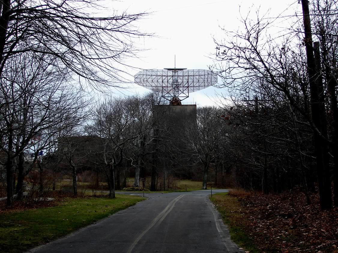
In 1957 the Army closed Camp Hero and it was taken over by United States Air Force which in 1958 built a 100-foot (30 m) wide AN/FPS-35 radar to detect incoming Soviet bombers. A massive building was built to house its computers. The radar quickly became obsolete.
In 1959, following the Kitchen Debate between United States Vice President Richard Nixon and Soviet Premier Nikita Khrushchev, the designers of the kitchen, including Raymond Loewy, announce plans to sell affordable prefabricated houses, called Leisurama, to be used for second homes. One of the houses was exhibited on the 9th floor of Macy's. Two hundred of the houses, the largest installation, were assembled at Culloden Point.
In 1967 the United States Coast Guard announced plans to tear down the Montauk Lighthouse and replace it with a taller steel tower. Erosion had reduced its buffer from the edge of a cliff from 300 feet (91 m) when it was built to less than 100 feet (30 m). The Coast Guard backed down after protests.
In 1982 the Air Force Base formally closed and the military began selling its surplus property.
In 1992, Long Island residents Preston B. Nichols and Peter Moon wrote a science fiction novel, The Montauk Project: Experiments in Time (ISBN 0-9631889-0-9) in which it was claimed the radar was used by the government to conduct time travel experiments. Among the claims is that it drove the residents of Montauk mad and that their children were kidnapped. The book and its follow-up books were to expand on many Montaukett tales and other East End stories. The book has been perceived by some to be true and the base has assumed something of a cult status among conspiracy buffs. It was also featured in a segment of the X-Files television series.
21st century
In October 2007 a fishing boat dragged up a large 19th century anchor, which was speculated to have been lost by the Great Eastern in 1862.[12]
On July 12, 2008 a reported "Montauk Monster" washed up on the shore and was not identified.
Tourism
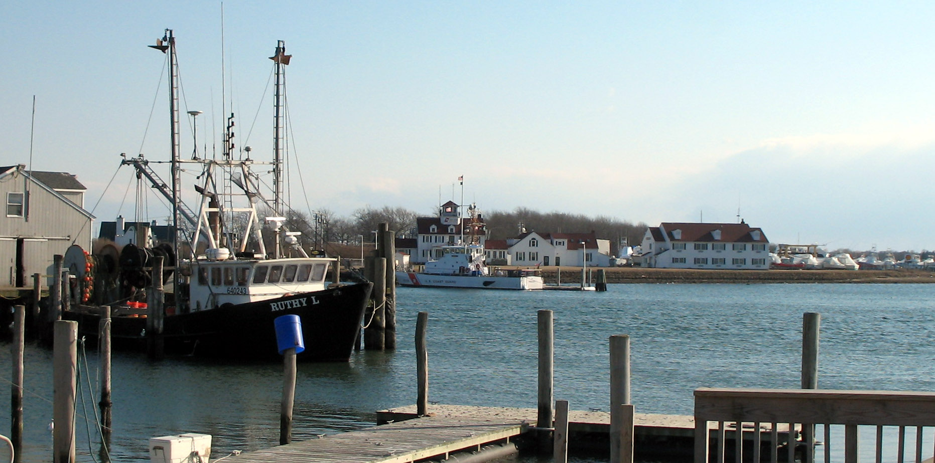
 Coast Guard station on Star Island in Lake Montauk
Montauk is considered a beach resort, using its position at the tip of Long Island to promote itself as "The Living End" or "The Last Resort" and become one of the busiest tourist locations within the town of East Hampton. The small town is host to many restaurants, bed and breakfasts, and hotels and is a popular vacation spot in the warm weather months. Such accommodations are rarer elsewhere in the Hamptons. Many of the Montauk hotels are only open April through November, some for shorter time periods, while a few serve fishermen and other customers year round, including the famed Gurney's Inn.
The Long Island Rail Road provides train service to Pennsylvania Station, New York, and Hampton Jitney provides bus service to Manhattan. Suffolk Transit's 10C and seasonally-operated S94 routes serve the village. The 10C connects the village with East Hampton, and the Amagansett, East Hampton and Montauk Long Island Rail Road stations on the Montauk Branch, and the seasonally-operated S94 connects the village with the Montauk Point Light. Small planes can fly into the Montauk Airport.
Lake Montauk, a small bay on the north side of town, is home to a US Coast Guard station and a small fishing fleet, both commercial and recreational.
In 2007, Newsday listed 47 businesses in the category of "Hotel" in Montauk. They represented 2,030 rooms.[1]. None of the hotels are operated by a chain as East Hampton town zoning regulations forbid chains (likewise there are no fast food or other restaurant chains in Montauk).
State parks
Six state parks are in Montauk. They are from west to east:
- Hither Hills State Park
- Shadmoor State Park
- Montauk Downs State Park
- Amsterdam Beach State Park
- Camp Hero State Park
- Montauk Point State Park
In addition there is Theodore Roosevelt County Park and several East Hampton parks and Nature Conservancy areas.
Climate
Climate data for Montauk, New York Month Jan Feb Mar Apr May Jun Jul Aug Sep Oct Nov Dec Year Average high °F (°C) 32
(0)38
(3)44
(7)53
(12)63
(17)73
(23)80
(27)78
(26)73
(23)61
(16)51
(11)36
(2)57 Average low °F (°C) 28
(−2)34
(1)38
(3)49
(9)59
(15)68
(20)74
(23)73
(23)68
(20)56
(13)47
(8)34
(1)53 Rainfall inches (mm) 3.73
(94.7)3.54
(89.9)4.52
(114.8)3.86
(98)3.71
(94.2)3.58
(90.9)2.90
(73.7)3.66
(93)3.36
(85.3)3.22
(81.8)4.38
(111.3)4.38
(111.3)44.84
(1,138.9)Source: [13] Geography
 U.S. Census designated area of Montauk
According to the United States Census Bureau, the hamlet has a total area of 19.8 square miles (51 km2), of which, 17.5 square miles (45 km2) of it is land and 2.3 square miles (6.0 km2) of it (11.53%) is water.
Demographics
As of the census of 2000, there were 3,851 people, 1,593 households, and 992 families residing in the CDP. The population density was 220.1 per square mile (85.0/km²). There were 4,815 housing units at an average density of 275.2/sq mi (106.3/km²). The racial makeup of the hamlet was 87.04% White, 0.86% African American, 0.10% Native American, 0.83% Asian, 9.76% from other races, and 1.40% from two or more races. Hispanic or Latino of any race were 23.92% of the population.[1]
There were 1,593 households out of which 26.9% had children under the age of 18 living with them, 47.0% were married couples living together, 8.7% had a female householder with no husband present, and 37.7% were non-families. 28.6% of all households were made up of individuals and 10.2% had someone living alone who was 65 years of age or older. The average household size was 2.41 and the average family size was 2.90.[1]
In the CDP the population was spread out with 20.0% under the age of 18, 6.6% from 18 to 24, 33.9% from 25 to 44, 25.0% from 45 to 64, and 14.5% who were 65 years of age or older. The median age was 39 years. For every 100 females there were 105.4 males. For every 100 females age 18 and over, there were 109.2 males.[1]
The median income for a household in the CDP was $42,329, and the median income for a family was $50,493. Males had a median income of $40,063 versus $28,299 for females. The per capita income for the CDP was $23,875. About 8.3% of families and 10.6% of the population were below the poverty line, including 10.9% of those under age 18 and 8.5% of those age 65 or over.[1]
Gallery
-
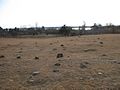
Montaukett burial field. The largest stone belongs to Stephen Talkhouse
-
Montauk Association house at Ditch Plains
-

Montauk's Long Island Rail Road station with Montauk Manor in the background
-

Montauk Manor
-

Montauk Improvement Building, now residential, and the gazebo in the middle of town
-

ANFPS-35 Radar
-
Leisurama home at Culloden Point
-
Fiberglass copy of the 3,427 pound 17-foot (5.2 m) long Great White Shark on the Lake Montauk waterfront. It is claimed to have been the biggest Great White caught by rod and reel.
See also
References
- ^ a b c d e f "American FactFinder". United States Census Bureau. http://factfinder.census.gov. Retrieved 2008-01-31.
- ^ "Long Island Fishing Charters And Party Boats". NY Fisherman. http://nyfisherman.net/longislandcharters.html. Retrieved 2010-04-17.
- ^ Rattiner, Dan (June 8, 2007). "Sharks to Vote?". Dan's Papers. http://www.danshamptons.com/content/danspapers/issue11_2007/01.html. Retrieved 2010-01-30.
- ^ Dickinson, Joan D. (August 1995). "Deep Hollow Ranch". American Cowboy. http://deephollowranch.com/history.htm. Retrieved 2010-04-17.
- ^ http://www.newsday.com/community/guide/lihistory/ny-history-hs216a,0,6109119.story
- ^ 1686 Dongan Patent
- ^ "Long Island Indians and The Early Settlers". Long Island Genealogy. http://longislandgenealogy.com/indians.html. Retrieved 2007-01-18.
- ^ Thompson, Benjamin Franklin (1839). History of Long Island; Containing an Account of the Discovery and Settlement; with Other Important and Interesting Matters to the Present Time. New York: E. French. p. 185. http://books.google.com/books?vid=OCLC01394364&id=cQb1Ye6C97sC&pg=PA185. Retrieved 2010-04-17.
- ^ The Material History of the Montaukett - Lecture by Gaynell Stone - East Hampton Public Library - January 31, 1998
- ^ Mead, Julia C. (January 15, 1998). "An Old Dayton House Saved From Bulldozer". The East Hampton Star. http://www.easthamptonstar.com/DNN/Archive/1998/980115/news1.htm. Retrieved 2010-01-30.
- ^ Clavin, Tom (2005). Dark Noon: The Final Voyage of the Fishing Boat Pelican. Camden, ME: International Marine. ISBN 0071486593.
- ^ Rattiner, Dan (October 19, 2007). "Great Eastern? Anchor from One of the World's Largest Ships Is Hauled Up off Montauk". Dan's Papers. http://www.danshamptons.com/content/danspapers/issue30_2007/04.html. Retrieved 2010-02-11.
- ^ "Weatherbase: Historical Weather for Montauk, New York". http://www.wunderground.com/history/airport/KHTO/2010/1/20/MonthlyHistory.html?req_city=NA&req_state=NA&req_statename=NA. Retrieved July 20, 2011.
External links
- Montauk Friends of Olmsted Parks/Montauk Trustee Corporation
- Montauk Friends of Erin organizers of the annual St. Patrick's Day Parade
Town of East Hampton, New York County Villages Hamlets Amagansett · Montauk · Napeague · Springs · Wainscott
CDP Website: town.east-hampton.ny.usCategories:- Census-designated places in New York
- East Hampton (town), New York
- Hamlets in New York
- Place names in New York of Native American origin
- Populated places in Suffolk County, New York


Wikimedia Foundation. 2010.