- Napeague, New York
-
Napeague — CDP — Mackay Tower and Art Barge


 Napeague
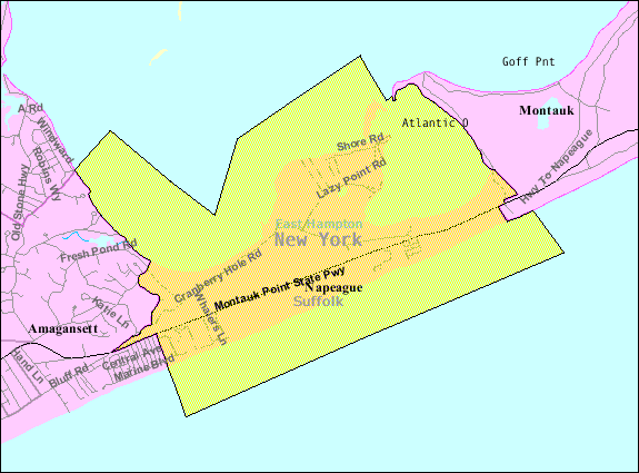
Coordinates: 40°59′42″N 72°4′30″W / 40.995°N 72.075°WCoordinates: 40°59′42″N 72°4′30″W / 40.995°N 72.075°W Country United States State New York County Suffolk Town East Hampton Area - Total 10.6 sq mi (27.3 km2) - Land 3.9 sq mi (10.1 km2) - Water 6.7 sq mi (17.3 km2) Elevation 7 ft (2 m) Population (2000)[1] - Total 223 - Density 57.4/sq mi (22.2/km2) Time zone Eastern (EST) (UTC-5) - Summer (DST) EDT (UTC-4) FIPS code 36-49424 GNIS feature ID 0958252 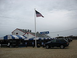 Lunch at the Lobster Roll restaurant in Napeague
Napeague (
 /ˈnæpiːɡ/, nap-eeg) is a census-designated place (CDP) that roughly corresponds to the hamlet (unincorporated community) with the same name in the town of East Hampton in Suffolk County, New York, United States. The CDP population was 223 at the 2000 census.[1]
Napeague is located on a very narrow, low lying strip between the Atlantic Ocean to the south and Gardiners Bay to the north that was flooded in the Great Hurricane of 1938. It lies between Napeague State Park on the west and Hither Hills State Park on the east.
Napeague derives its name from the Montaukett name for "land overflowed by the sea."[2]
Contents
Landmark structures
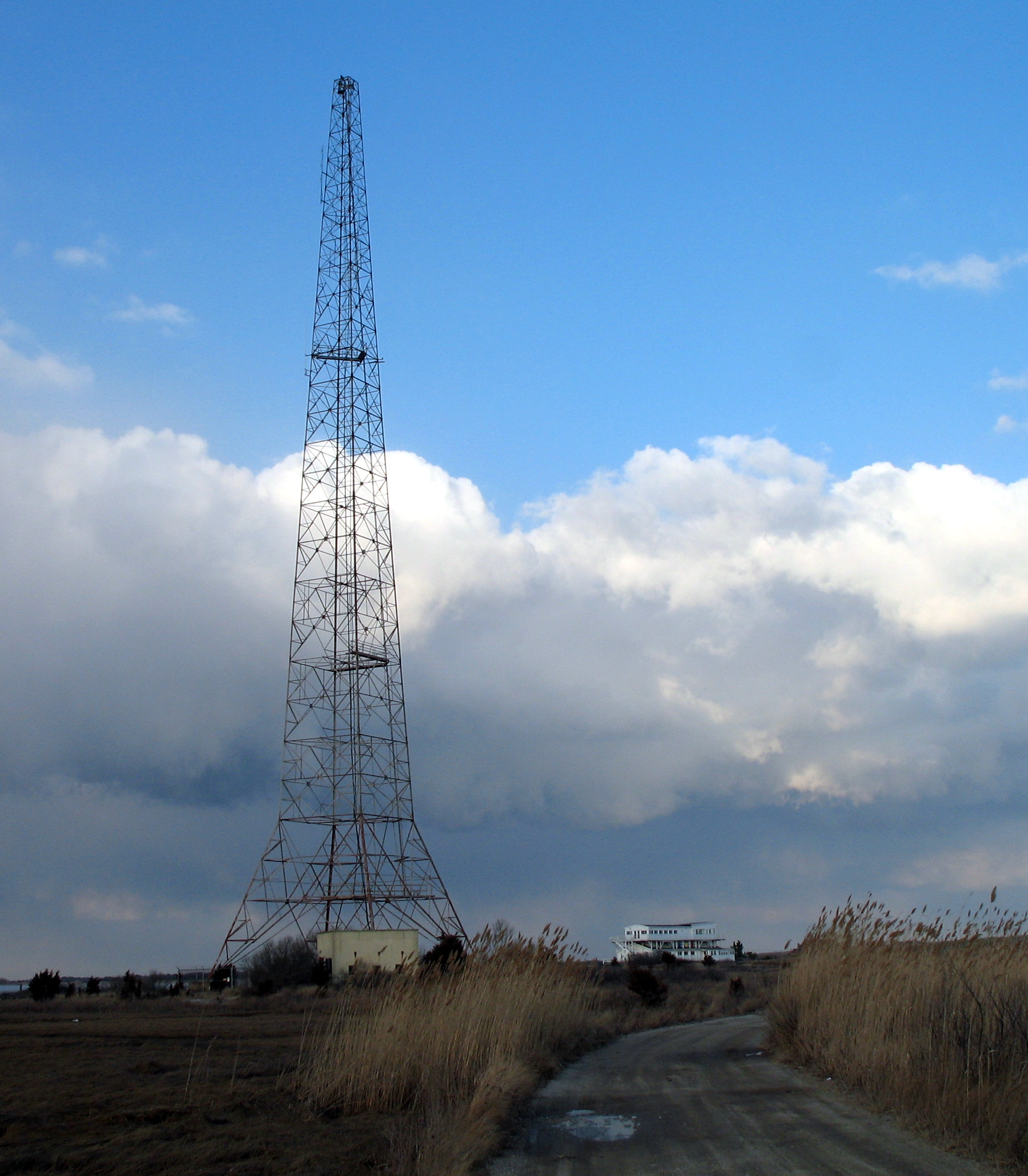
The hamlet's three major landmarks are the Mackay Radio Tower, the Art Barge, and the Smith Meal Fish Factory.
Mackay Radio Tower
The Mackay Radio Tower is the last of two towers (originally 300 feet (91 m) high 1,000 feet (300 m) apart) that was used to transmit international point to point radio communications starting in 1927. At the height of World War II the tower was used for responding to upwards of ten SOS calls a day from ships at sea.[3] The tower had somebody on site 24 hours a day but the actual transmissions were keyed from Southampton. The towers toppled during the Great 1938 Hurricane.
At 12:35 pm. on January 28, 1961 an American Airlines Boeing 707 Flight 1502 (Flagship Oklahoma) with an engine on fire nosedived over the towers before crashing about 300 yards off the Napeague coast killing all six aboard. The plane had been on a training flight from Idlewild Airport. An often repeated story says the plane clipped one of the towers but The New York Times account of the crash says it just missed the towers.[4]
The Mackay towers were decommissioned in 1984[5] and its underlying land is part of Napeague State Park. One of the towers was torn down. The remaining tower is used for communication purposes by the New York State Police.[6] Its flashing white lights are visible throughout coastal areas of East Hampton.
Art Barge
The Art Barge is the home of the Victor D'Amico Institute of Art. Victor D'Amico was Director of Education for the Museum of Modern Art from 1937 until 1970. In 1955 the Department had begun art classes at Ashawagh Hall in Springs, New York. D’Amico, looking for a permanent home, worked with local baymen to dock a barge at its current location just northeast of the Mackay Towers. It was originally called Kearsarge, a Native American word meaning "place of heaven.” However the popular name of art barge stuck. A second story was added later. The barge now operates June through September.[7]
Smith Meal Fish Factory
The large shed of the Smith Meal Fish Factory in Promised Land was a plant that processed menhaden fish for fish meal. It was owned by Otis Smith and produced between 20-30 million fish a year from June to October and had its own Long Island Rail Road siding. After a drop in the supply of menhaden, Smith closed the plant in 1969 along with plants at Lewes, Delaware and Crab Island, New Jersey. The plants were consolidated at Port Monmouth, New Jersey.[8] next to the smith meal plant is a private marine finfish hatchery Multi Aquaculture Systems and a small restaurant,the sea slug lounge .[9]
The Smith Meal Fish Factory is part of the Napeague State Park and is the subject of an ongoing court battle about whether it should be used as a dock for the Cross Sound Ferry for a car ferry service to New London, Connecticut.[10]
Water Sports
Napeague Harbor is also a well known kiteboarding and windsurfing destination on Long Island. With flat waters and steady wind, Napeague is used by beginners and advanced riders.[11]
Geography
According to the United States Census Bureau, the CDP has a total area of 10.6 square miles (27 km2), of which, 3.9 square miles (10 km2) of it is land and 6.7 square miles (17 km2) of it (63.22%) is water.
At the end of the last ice age, Napeague was submerged under the sea. (At that time, Montauk was an island.) In the intervening several thousand years, ocean currents, or littoral drift, filled in this space with sand, giving rise to Napeague.
The main settlement in Napeague is the small community of Lazy Point, also known as "Promised Land". It acquired this nickname, according to local lore, because of the menhaden plant located there in years gone by, which "stunk to high heaven".[citation needed]
Demographics
As of the census of 2000, there were 223 people, 105 households, and 64 families residing in the CDP. The population density was 57.4 per square mile (22.2/km²). There were 624 housing units at an average density of 160.7/sq mi (62.1/km²). The racial makeup of the CDP was 97.31% White, 0.90% African American, 1.35% Native American, and 0.45% from two or more races. Hispanic or Latino of any race were 6.73% of the population.[1]
There were 105 households out of which 17.1% had children under the age of 18 living with them, 46.7% were married couples living together, 10.5% had a female householder with no husband present, and 39.0% were non-families. 33.3% of all households were made up of individuals and 10.5% had someone living alone who was 65 years of age or older. The average household size was 2.12 and the average family size was 2.59.[1]
In the CDP the population was spread out with 15.2% under the age of 18, 6.3% from 18 to 24, 23.3% from 25 to 44, 32.3% from 45 to 64, and 22.9% who were 65 years of age or older. The median age was 48 years. For every 100 females there were 108.4 males. For every 100 females age 18 and over, there were 107.7 males.[1]
The median income for a household in the CDP was $44,688, and the median income for a family was $48,333. Males had a median income of $37,500 versus $31,875 for females. The per capita income for the CDP was $23,403. About 9.7% of families and 13.3% of the population were below the poverty line, including 25.0% of those under the age of eighteen and none of those sixty five or over.[1]
References
- ^ a b c d e f "American FactFinder". United States Census Bureau. http://factfinder.census.gov. Retrieved 2008-01-31.
- ^ The Sag Harbor Express
- ^ "Wireless History". http://longislandgenealogy.com/Wireless/Wireless.html. Retrieved 2009-08-19.
- ^ "6 Die as Jetliner Crashes Off L.I. on Training Flight". The New York Times: p. 1. January 29, 1961. http://select.nytimes.com/gst/abstract.html?res=F10A14FB34551B728DDDA00A94D9405B818AF1D3. Retrieved 2011-09-21.
- ^ "Radio Facilities on Long Island". http://www.mackayhistory.com/Mackay_Radio_2.html. Retrieved 2009-08-19.
- ^ Rather, John (April 30, 2006). "Eyesore Or Not, A Tower Is Likely". The New York Times. http://query.nytimes.com/gst/fullpage.html?res=9C0CE3DD133FF933A05757C0A9609C8B63. Retrieved 2009-08-30.
- ^ "History of the Art Barge". http://www.theartbarge.com/?page_id=15. Retrieved 2010-10-20.
- ^ Sherrill, E.L. III (April 12, 2007). "Recalling Captain Norman". The East Hampton Star. http://www.easthamptonstar.com/DNN/Default.aspx?tabid=1896. Retrieved 2009-08-19.
- ^ Rattiner, Dan (June 12, 2009). "Historic Napeague Chimney May Be Taken Down". Dan's Papers. http://www.danshamptons.com/content/danspapers/issue12_2009/07.html. Retrieved 2009-08-30.
- ^ Rattiner, Dan (June 26, 2009). "Rule Upheld: Car Ferry Nixed in East Hampton". Dan's Papers. http://www.danshamptons.com/content/danspapers/issue14_2009/08.html. Retrieved 2009-08-19.
- ^ Nadel, Laurie (May 19, 2002). "Finding An Inner Balance, Chasing A Dream". The New York Times. http://www.nytimes.com/2002/05/19/nyregion/finding-an-inner-balance-chasing-a-dream.html. Retrieved 2009-08-19.
External links
Town of East Hampton, New York County Villages Hamlets Amagansett · Montauk · Napeague · Springs · Wainscott
CDP Website: town.east-hampton.ny.us Categories:- Census-designated places in New York
- Hamlets in New York
- East Hampton (town), New York
- Populated places in Suffolk County, New York
- Place names in New York of Native American origin


Wikimedia Foundation. 2010.