- Mount Dennis
-
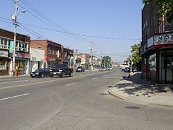
Mount Dennis — Neighbourhood — Weston Road in Mount Dennis Coordinates: 43°41′6.14″N 79°29′9.37″W / 43.6850389°N 79.4859361°WCoordinates: 43°41′6.14″N 79°29′9.37″W / 43.6850389°N 79.4859361°W Country  Canada
Province  Ontario
City  Toronto
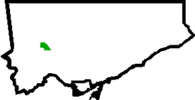
Community Etobicoke-York Changed Municipality 1998 Toronto from York Government - MP Mike Sullivan (York South—Weston) - MPP Laura Albanese (York South—Weston) - Councillor Frances Nunziata (Ward 11 York South-Weston) Mount Dennis is a neighbourhood in Toronto, Ontario, Canada, bordered by the intersection of Jane Street and Weston Road to the north, and Black Creek to the east and south, as the creek curves parallel to Alliance Avenue before crossing under Jane Street on its way to drain into the Humber River, which creates a natural border to the west. Eglinton Avenue West is a major transportation corridor within Mount Dennis. Had Metropolitan Toronto's planned municipal expressway system been completed, the neighbourhood would have been bisected by the Richview Expressway.
The area gets its name from the Dennis family (lead by John Dennis (1758-1832)), Loyalist shipbuilders who owned the property, as well as a boatyard on the Humber, at the turn of the 19th century. It remained largely rural, with orchards, gravel and clay pits and a few market gardens, until Kodak Canada moved its factory to a site at Eglinton Avenue and Weston Road, along the rail line running next to Weston Road, during World War I. This factory complex, known as "Kodak Heights," was a major employer for Mount Dennis' residents until it was shut down in 2005.
The area became what urban geographer Richard Harris described as an "unplanned suburb" in his book, Unplanned Suburbs: Toronto's American Tragedy 1900 to 1950 (Johns Hopkins University Press, 1996). Workers at Kodak and the nearby stockyards once located at Weston Road and St. Clair Avenue, as well as CCM, Willys Overland and other factories north and south of Mount Dennis built their own homes before municipal services were in place, and small developers built "infill" homes, gradually filling the streets with the current housing stock of former cottages and small, fully detached homes, among the most affordable housing stock in Toronto for recent immigrants and first-time homeowners.
The area is a classic example of Toronto's diversity, with dozens of ethnic groups represented, however the largest ethnic group by far are from the Caribbean and West Africa with the vast majority of visible minorities of Jamaican descent. With respect to religion, there are many black store front churches representing the many faiths of the African and Caribbean communities as well as Western-European, Middle Eastern and Asian faiths such as Christian, Roman Catholicism, Pentecostalism, Seventh Day Adventist), Muslim, and Buddhist. Among the languages spoken are Spanish, Vietnamese, and Portuguese.(Source: Statistics Canada 2006 Census).External links
- City of Toronto - Mount Dennis Neighbourhood Profile
- The York Guardian: Employment study proceeding for Kodak lands - February 14, 2008
- Kodak - Canadian Enterprises

Weston 
Humber Heights-Westmount (Etobicoke) 
Amesbury, Silverthorn  Mount Dennis

Rockcliffe-Smythe Categories:- Neighbourhoods in Toronto
Wikimedia Foundation. 2010.


