- Davenport, Toronto
-
Davenport — Neighbourhood — 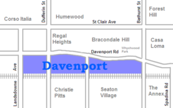 Location within Toronto

Country  Canada
Province  Ontario
City  Toronto
Community Toronto Davenport is a neighbourhood northwest of downtown in Toronto, Canada. It is located north of the Canadian Pacific Railway tracks and Dupont Avenue and south of Davenport Road and the ridge that is the former Lake Iroquois coastline. Its eastern boundary is Bathurst Street and it stretches west to Lansdowne Avenue.
Davenport Road follows a centuries old carrying trail used by the First Nations peoples to travel the route south of the ridge. It was also used as an important route by the early European settlers to the region and the area that is today Davenport became home to small farms in the early nineteenth century. One of the first settlers was Ensign John McGill, who built a home he named Davenport in 1797. This was named after Major Davenport, another local officer, and is the origin of the area's name (the name Davenport is of Norman French origin: Dauen-port meaning "the town on the trickling stream").
In 1861 the Northern Railway ran a rail line to the south of Davenport Rd and built a station in the area which they named Davenport. A small village, also named Davenport, grew up around the station. In 1889 the village merged with the nearby villages of Carleton and West Toronto Junction to form the town of Toronto Junction. In 1909 this was annexed to the city of Toronto itself. Like the rest of the area known as The Junction in the early twentieth century the presence of the railway lead to the industrialization of the area and many small plants and factories were set up in the area along the tracks. The residential areas to the north became home to the working class population the worked there, especially Italian Canadians, who dominated the neighbourhood and the nearby Corso Italia by the 1950s. It today remains home to many Italian and Portuguese residents, but since the departure of most of the factories in the 1970s and 1980s the area has been somewhat gentrified taking on some of the characteristics of nearby areas like the Annex. New townhouse developments have been built in the area replacing former factories and warehouses.
The neighbourhood gives its name to the Davenport, a federal and provincial electoral district that covers it and a number of neighbouring areas.
Landmarks
- Tollkeeper's Cottage (built c.1830)
- Hillcrest TTC Yard
References

Bracondale Hill The Junction 
Casa Loma  Davenport

Wallace Emerson, Dovercourt Park, Seaton Village Categories:- Neighbourhoods in Toronto

Wikimedia Foundation. 2010.