- Smithfield, Toronto
-
Smithfield — Neighbourhood — Kipling Ave in Smithfield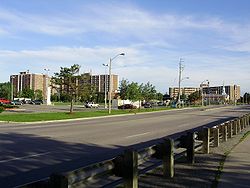


Coordinates: 43°44′23″N 79°34′49″W / 43.73972°N 79.58028°W Country  Canada
Province  Ontario
City  Toronto
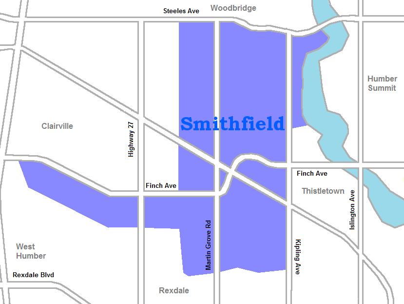
Community Etobicoke-York Established 1909 Postal village 'Etobicoke' Changed Municipality 1998 Toronto from Etobicoke Government – MP Kirsty Duncan (Etobicoke North) – MPP Shafiq Qaadri (Etobicoke North) – Councillor Vincent Crisanti (Ward 1 Etobicoke North) Smithfield is part of the Rexdale neighbourhood in the northwestern area of Etobicoke, in the City of Toronto, Ontario, Canada. Some new residents to Toronto and new immigrants to Canada are attracted to this neighbourhood, mainly because there is a large amount of affordable public housing. It is named after the former village of Smithfield that was located at the intersection of Albion and Martin Grove.
The neighbourhood covers the residential areas of Etobicoke north of the west branch of the Humber River and west of Kipling Avenue. The west and north of the neighbourhood are large industrial areas. For social purposes, the city identifies the neighbourhood as Mount Olive-Silverstone-Jamestown, named for three streets in the area. Mount Olive is the name given to the area north of Albion Road between Kipling and Martin Grove. Jamestown is the part of the community south of Albion between Kipling and Martin Grove. Silverstone covers the area west of Martin Grove and north of Finch. The northernmost section of the neighbourhood, above the hydro right of way, is known as South Steeles. The western projection of the area running along the south side of Finch is known as Woodbine Downs.
Contents
Character
The community, once home to a large Anglo-Saxon population, experienced a large influx of citizens from Eastern Europe, Asia, and the Caribbean. The impact of the various cultures has led to a communal diversity that can be said to be unparallelled in any area of such small size. The North Albion Collegiate Institute, located on Kipling and Mount Olive, has for years held showcases for the Asian and South East Asian Communities, attracting audiences from far and wide. Directly across the street, the St. Andrews School and Father Henry Carr Secondary School reflect the Catholic tradition and culture that is shared by many resident Filipinos, Assyrians, and Chaldeans.
The Albion Centre (formerly known as "Albion Mall") Is the main shopping venue in the area. Containing a variety of small boutiques and stores, the Albion Centre also contains such franchises as Pizza Pizza, Canadian Tire, and Shoppers Drug Mart. The Albion Cinemas have been operating since before 1994 and are still in operation. The cinemas, well known for their broadcasts of modern Bollywood/Indian/Asian films, have attracted many to this location.
In May 2006, Toronto Police apprehended 106 members of the "Jamestown Crew" in the largest gang sweep in Toronto's history. In total, there were over 1,000 charges laid in the anti-gang offensive called Project XXX.[1] Sometimes known by the nickname Doomstown because of its reputation as a poor neighbourhood ridden with gang violence, the neighbourhood was the setting of the 2006 Canadian television movie Doomstown.
Institutions
- Humber College North Campus
- Etobicoke General Hospital
- Albion Public Library[2]
- Albion Community Centre
- Albion Centre[3]
- Finch Albion Centre
- Smithfield Park
- Highfield Park
- Churches
- Martingrove United Church
- Kipling Baptist Church
- Thistletown Baptist Church [4]
- Gurudwaras
- Rexdale Singh Sabha Religious Centre
- Sikh Spiritual Centre Toronto
Schools
- Albion Heights Junior Middle School
- Beaumonde Junior Middle School - A public elementary school near the intersection of Albion Road and Finch Avenue. It was opened in 1959 as a Kindergarten to Grade 8 school. From 1970 until 1984, the school operated from Kindergarten to Grade 5. After 1984, it reverted to a full elementary program.
- Elmbank Junior Middle Academy - A public elementary school located at 10 Pittsboro Drive, near the corner of Martin Grove Road and Finch Avenue. It opened in 1967.
- Greenholme Junior Middle School - A public elementary school located at 10 Jamestown Crescent, close to the intersection of Albion Road and Kipling Avenue. It overlooks the Humber River.
- Highfield Junior School - A public elementary school located at 85 Mount Olive Drive, which opened in 1845. At the top of the school crest burns the lamp of learning that has lit the way for young children for over 160 years. The three bells on the crest represent the three locations for the school since 1845 when the first log schoolhouse was erected in the village of Highfield. The black iron school bell from the brick 1874 schoolhouse hangs at the end of the new student forum, part of the extensive addition completed in 1997. In September 2006, Highfield earned the National Quality Institute's Blue Leaf Award for excellence in education.
- Melody Village Junior School - A public elementary school located at 520 Silverstone Drive. It was built in 1970.
- Smithfield Middle School - A public middle school located at 175 Mount Olive Drive. It officially opened on October 17, 1966.
- John D. Parker Junior School - A public elementary school located at 202 Mount Olive Drive. It was opened in 1974 and was expanded in 1994 and 1996. The school was named in honour of Mr. John D. Parker, one of the original seven trustees elected to the Board of Education for the Township of Etobicoke in May 1969. He served on the Board from that time until the end of 1972.
- St Angela Catholic Elementary School
References
External links
- City of Toronto - Mount Olive-Silverstone-Jamestown Neighbourhood Profile
- Rap Dictionary: Jamestown
- Rap Dictionary: Mount Olive

Vaughan, Ontario Clairville 
Thistletown
Humber Summit (North York) Smithfield

Rexdale Categories:- Neighbourhoods in Toronto


Wikimedia Foundation. 2010.