- Davisville Village
-
For the community in the United States, see Davisville, West Virginia.
Davisville — Neighbourhood — Skyline of Davisville Village, 2009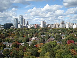 Vicinity
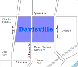 Location within Toronto

Country  Canada
Province  Ontario
City  Toronto
Davisville Village is an area of Toronto near the intersection of Davisville Avenue and Yonge Street. There is a subway station named Davisville at this intersection. The area directly abuts Mount Pleasant Cemetery, and has a large number of massive apartment and condominium complexes built between the 1970s and the 2000s, as well as a number of office buildings. The area is an attractive area in Midtown Toronto between St Clair and Eglinton.
The Davisville Pottery Company was originally located on Davisville Avenue which was the main source of activity through the nineteenth century. Wood and paper mills also existed in the area. Neither currently exists.
Divisions
The city of Toronto assigns the Davisville Village into two neighbourhoods:
Mount Pleasant West is situated West of Mount Pleasant Road, North of Merton Street, East of Yonge Street and South of Keewatin Ave. Ninety one percent of people in this neighbourhood live in low or high rise apartment / condo buildings, which makes it one of the most building dominated neighbourhoods in entire city (comparable with the high rise ridden downtown core source: Statistics Canada). There is a number of affordable housing units in the area which factors into the lower income levels in this hood compared to every surrounding neighbourhood. Over 80% of the residents in this neighbourhood are renters, which is approximately 30% over the average of the city.
Mount Pleasant East is bordered to the east by Bayview Ave, Moore Ave to the South, Yonge street to the West and Blythwood to the North. The people in this neighbourhood are predominantly in working years and enjoy an average income and average house value well above the norm for the city (Statistics Canada). While not the most affluent of neighbourhoods it is comparable to The Beaches in demographics, income and people.

Yonge and Eglinton Chaplin Estates 
Leaside  Davisville

Mount Pleasant Cemetery, Moore Park Former municipalities of Toronto by year of amalgamation 1883-1912 1883: Yorkville · 1884: Brockton · Riverdale · 1888: Seaton Village · 1889: Parkdale · 1890: Bedford Park · Davisville · 1905: Rosedale · 1908: Deer Park · East Toronto · 1909: Bracondale · West Toronto · Wychwood · 1910: Moore Park · North Toronto · 1912: Dovercourt · Earlscourt1967 1998 Categories:- Neighbourhoods in Toronto


Wikimedia Foundation. 2010.